• Skip to main content
  • Skip to header right navigation
  • Skip to after header navigation
  • Skip to site footer
Florida Hikes logo

Florida Hikes

Hike Bike Paddle Camp Florida with authors Sandra Friend and John Keatley as your guides

  • Trails
  • Maps
  • Guidebooks
  • Hike
    • Scenic Hikes
    • Loop Trails
    • Dog-friendly Hikes
    • Hikes for Kids
    • National Parks in Florida
    • Florida State Parks
  • Bike
    • Major Bike Trails
    • Paved Bike Trails
    • Off Road Biking
    • Biking Articles
  • Paddle
    • Canoe & Kayak Rentals
    • Paddling Destinations
    • Paddling Articles
  • Camp
    • Cabin Rentals
    • Car Camping
    • Primitive Camping
  • Florida Trail
    • Plan your Hike
    • Best Scenic Hikes
    • Best Backpacking
    • Section Hiking
    • Thru-Hiking
    • Trail Updates
  • Travel
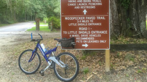
Bike in front of state park sign

Big Shoals Woodpecker Trail

Spanning 3.5 miles between the entrances to Big Shoals State Park, the paved Woodpecker Trail makes for an easy 7 mile round-trip when it’s not wet.

White Springs (30.34459, -82.73609)   3.5 miles   Big Shoals State Park
CLOSED as of Mar 2025 due to a damaged bridge

The single paved trail inside Big Shoals State Park, the Woodpecker Trail is definitely in the woods.

It’s linear, but winds around curves to make the short ride more interesting, including the likelihood of happening across wildlife on the trail.

Paved path in pine woods Curve along trail in pine woods


We should have suspected the ride to be challenging when we couldn’t access the end at the Big Shoals Entrance due to road conditions. It was almost impassable.

Not wanting the ruts and dips in the road–deep enough to swallow the tire of our little Honda–to strand us, we backtracked to Little Shoals trailhead.

Bike in front of state park sign Big Shoals Entrance sign


The sign at that end said “Coming soon! Turkeys, gopher tortoises, and quail!”

It said nothing about the flooded places that we’d encounter just ahead after the recent afternoon rains.

Blurry bike path with puddle reflecting pines Whizzing past a large puddle


Resources

Resources for exploring the area
Florida Trail Hikes book cover The Florida Trail Guide book cover North Florida Panhandle Explorers Guide book cover 50 Hikes in North Florida book cover Hikers Guide to the Sunshine State book cover Paddlers Guide Florida The Hiking Trails of Floridas National Forests Parks Preserves book cover
 
Disclosure: As authors and affiliates, we receive earnings when you buy through our links. This helps us provide public information on this website.

Overview

Location: White Springs
Length: 3.5 miles linear
Trailhead: 30.34459, -82.73609
Fees: $4 per vehicle
Restrooms: Privy at Little Shoals, flush toilet at Big Shoals
Land manager: Florida State Parks
Phone: 386-397-4331

Open 8 AM to sunset. Leashed dogs welcome. Trail can be accessed from either end.


Directions


From Interstate 75, head east on SR 136 E for 3 miles into the town of White Springs. Turn right onto US 41. In a half mile, turn left onto SE CR 135. Drive 1.4 miles to the trailhead on the right.

Ride

The trailhead was just inside the gate and no trouble at all to drive to. It had a paved parking area, picnic shelter, and a privy.

After pumping air in the tires of our bikes, we began our 3.5 mile ride on the paved trail.

Paved path with sign under pines Start of the trail at the Little Shoals Trailhead


Our plan was to reach the parking area above the Suwannee River at Big Shoals State Park, where there are restrooms and a quick walk down to the river at the canoe launch.

The golden orb spiders must know people ride this trail. Their webs were just above our heads. We rode past the big sign and a covered bench.

Covered bench One of the covered benches for hikers


Continuing over a boardwalk through a scenic piece of woods, we splashed through two small sections of trail.

Here, the water was flowing about an inch deep and ten feet wide. Not a problem.

Puddles on paved trail in woods A big puddle on the trail


But then we arrived at the first water hazard. The trail was entirely flooded under dark tannic water in the pine flatwoods.

With no way to know the depth of the water, Sandy waited at the water’s edge while I continued my way along the flooded bike path.

Expanse of water filling paved trail There’s deep, and there’s DEEP. This was crazy deep across the Woodpecker Trail


As the water reached my boots, I kept pedaling. When the tops of my boots slipped under water, I called back to Sandy not follow me.

I was afraid that water’s depth might force me off the bike to push the bike through the water and I did not want her to even try.

My forward motion was nearly at a stall before the water became shallower. Every pedal stroke became easier and I was able to made it across without dismounting.

Shadow of cyclist on pavement It was a relief to be on dry pavement again


Safely across the flooded path, I called back to Sandy telling her that I would quickly ride to the end so we could document this trail.

I had not given any thought to there being more flooded trail sections. Around a bend I startled four deer along and on the path.

They quickly disappeared into the woods before I could even think of taking a picture.

Mileage marker in weeds along paved path Riding past the Mile 2 marker


I crossed two boardwalks, a bridge, and two more flooded trail sections before I reached the three mile mark and the end of my camera battery.

The trailhead was empty when I reached the end of the paved trail. At least I had a phone to snap a photo with.

Bike in front of state park sign Big Shoals end of the Woodpecker Trail


Just looking at the road, from here it would have been a very wet and muddy ride for a view of Big Shoals and the Suwannee River.

So with Sandy waiting at the other end, I began my return. At least I knew what the trail conditions would be on the way back, and that my feet would stay wet.

View of tannic creek from bridge Bridge over Four Mile Branch


Along the way, my four white deer friends walked out on the trail. They must have known that the camera battery was dead.

This time they slowly ambled back into the woods. Seeing them again, I forgot that my wet feet and just enjoyed the rest of the ride.

Boardwalk on paved path Boardwalk along the trail


I met Sandy on the “dry” side of the trail. When I got back through the flooding, Sandy said I looked exhausted. I was!

She had her own story to tell. She rode out to the trailhead and back again, then decided to wait for me at the flooded section.

Bike path with water and reflections Water flowing across the bike path


While standing straddling her bike, she saw something move in the water and thought about cottonmouths being in there.

She looked down and there was a large black racer at her feet, intent on watching a frog at the water’s edge. She was almost stepping on it without knowing it was there.

Butterfly on bike tire The butterflies were more obvious


On the way back to our hotel, we heard a loud pop and pssst sound from the rear of the car. I quickly pulled off the road.

Looking in the trunk I found the front tire on the bike I had just ridden had gone, flat. At least it happened after my ride and not while I was in knee-deep water!

John and his bike Riding through deep water was exhausting


This is one you’ll want to ride round-trip because it’s short and the Little Shoals Trailhead is much easier to get to.

It was a 7-mile round trip, but would be 7.6 if you visited the Big Shoals entrance trailhead and turned around there. Watch out for those wet spots!

Cyclist along paved trailEnjoy the ride!


Trail Map

Big Shoals Trail Map
Blue: Woodpecker Trail. Purple: Long Branch Trail. Red: Big Shoals Trail. Orange: Florida Trail.

Explore More!

Learn more about Big Shoals State Park
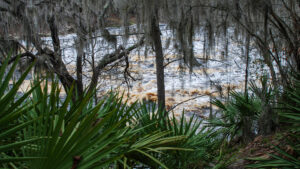
View of rapids framed by Spanish moss and palmetto Big Shoals State Park Florida's largest series of rapids churn the Suwannee River into Class III whitewater along the stretch of river bounded by Big Shoals State Park.


Slideshow

See our photos from this ride


Nearby Adventures

Path in forest adjoined by large log Big Shoals Long Branch Trail Traversing seasonally flooded forests on contoured landscapes, the Long Branch Trail provides hikers and cyclists unique sights along the Suwannee River.
Big Shoals within river Big Shoals Trail Traverse tall bluffs above the Suwannee River for spectacular views of Florida's only Class III whitewater rapids from the Big Shoals Trail.
White Springs Tract Florida Trail, White Springs 3.6 miles. Spanning from one end of White Springs to the other along a bend in the Suwannee River, this Florida Trail segment is an easy day hike through a historic community.
Panoramic view of shoals across river Florida Trail, Big Shoals 4.6 miles. Showcasing Florida's only Class III whitewater, the hike from Bell Springs to Big Shoals is one of the most scenic segments of the Florida Trail along the Suwannee River.

Trail Map (PDF) Singletrack Map (PDF) Official Website

  • Author
  • Recent Posts
John Keatley
John Keatley
A native Floridian from the Space Coast, John Keatley grew up on the water and in the woods. Co-author of a dozen guidebooks, he's an avid cyclist and paddler, sometimes covering those topics jointly with his wife Sandra Friend.
John Keatley
Latest posts by John Keatley (see all)
  • Riding the East Coast Greenway to Stuart - July 14, 2022
  • Pioneer Paddling Trail - May 11, 2022
  • Launching Into Paddleboarding - October 17, 2021
Category: Articles, Biking, Cycling, Day Hikes, Hikes, North Florida, Paved Bike Trails, TrailsTag: Best Bike Rides, Big Shoals State Park, Bike Path, Dog-friendly, Florida State Parks, Lake City, White Springs

Sidebar

FarOut Guides

Our comprehensive trail logistics presented on offline maps:

Florida National Scenic Trail (1,500 miles)
Florida Keys Overseas Heritage Trail (108 miles)
Eastern Continental Trail in Florida (92 miles)


We earn a small commission on sales through these links. Thanks for your support!


Our Guidebooks

We’ve written Florida guidebooks for over 25 years. These include North Florida destinations.

Book cover with woman hiking through palms with baby carrier
Book cover of Florida Trail Hikes
The Florida Trail Guide fifth edition
Explorer's Guide North Florida & The Panhandle guidebook

Explore More

Newest Articles for North Florida

Deep water-filled crevices Little Awesome Preserve
Longleaf pine forest LEAFS Preserve South
Paved bike path surrounded by pines and grassy slope Lehigh Trail
Aqua blaze on pine trunk next to footpath in flatwoods Dahoma Historic Trail

  • Facebook
  • Flickr
  • Instagram
  • Pinterest
  • Substack
  • Vimeo

FIND A TRAIL OR PARK

METROS: Bradenton. Clearwater. Crestview. Daytona Beach. Destin. Fort Lauderdale. Fort Myers. Fort Walton Beach. Gainesville. Jacksonville. Kissimmee. Lakeland. Melbourne. Miami. Naples. Ocala. Orlando. Panama City Beach. Pensacola. Port St. Lucie. Punta Gorda. St. Petersburg. Sanford. Sarasota. Sebring. Stuart. Tallahassee. Tampa. Vero Beach. West Palm Beach.

MULTI-REGION: Atlantic Coastal Ridge. Atlantic Coast. Bartram Trail. Big Bend. East Coast Greenway. Everglades National Park. Florida National Scenic Trail. Gulf Coast. Lake Wales Ridge. WATERWAYS: Indian River Lagoon. Intracoastal Waterway. Kissimmee River. St. Johns River. Withlacoochee River.

NORTHWEST FLORIDA: Altha. Apalachicola. Apalachicola National Forest. Big Bend Scenic Byway. Blackwater River State Forest. Blountstown. Bonifay. Bristol. Bruce. Cantonment. Cape San Blas. Carrabelle. Chattahoochee. Chipley. Crawfordville. DeFuniak Springs. Eastpoint. Ebro. Eglin Air Force Base. Freeport. Fountain. Gulf Breeze. Gulf Islands National Seashore. Holt. Madison. Marianna. Milton. Monticello. Mossy Head. Munson. Navarre. Navarre Beach. Newport. Niceville. Panacea. Panama City . Perdido Key. Ponce De Leon. Port St. Joe. Quincy. Santa Rosa Beach. Sopchoppy. South Walton. St. George Island. St. Marks. St. Marks NWR. Sumatra. Vernon. Wakulla. Wewahitchka. Woodville. WATERWAYS: Apalachicola River. Blackwater Bay. Blackwater River. Chipola River. Choctawhatchee Bay. Choctawhatchee River. Coastal Dune Lakes. Ochlockonee Bay. Perdido River. St. Marks River. Wacissa River. Wakulla River. Yellow River.

NORTH FLORIDA: Alachua. Amelia Island. Archer. Baldwin. Branford. Bronson. Bunnell. Callahan. Cedar Key. Chiefland. Crescent City. Cross City. Cross Creek. Dowling Park. Ellaville. Fanning Springs. Fernandina Beach. Flagler Beach. Fort White. Glen St. Mary. Green Cove Springs. Hawthorne. High Springs. Inglis. Jacksonville Beaches. Jacksonville Northshore. Jasper. Jennings. Keystone Heights. Lake Butler. Lake City. Live Oak.Macclenny. Mandarin. Mayo. Mayport. Micanopy. Middleburg. Old Town. Olustee. Orange Park. Osceola National Forest. Palatka. Palatka-Lake Butler Trail. Palm Coast. Palm Valley. Perry. Ponte Vedra. Rodman. Salt Springs. St. Augustine. Starke. Steinhatchee. Suwannee. Suwannee River Wilderness Trail. Suwannee Springs. Talbot Islands. Timucuan Preserve. Trenton. Waldo. Welaka. White Springs. Williston. Worthington Springs. Yankeetown. WATERWAYS: Santa Fe River. St. Marys River. Suwannee River. Tolomato River. Upper Withlacoochee River.

CENTRAL FLORIDA: Altamonte Springs. Apollo Beach. Apopka. Astatula. Astor. Auburndale. Bartow. Babson Park. Bayport. Belleview. Bithlo. Brandon. Brooksville. Bushnell. Canaveral National Seashore. Cassadaga. Christmas. Chuluota. Citrus Springs. Clearwater Beach. Clermont. Coast to Coast Trail. Cocoa. Cocoa Beach. Cross Florida Greenway. Crystal River. Dade City. De Leon Springs. DeBary. Deland. Deltona. Dunedin. Dunnellon. Edgewater. Enterprise. Eustis. Ferndale. Fort Meade. Frostproof. Geneva. Gibsonton. Haines City. Hernando. Hernando Beach. Holopaw. Homosassa. Inverness. Kenansville. Kissimmee. Lake Mary. Lake Wales. Largo. Leesburg. Lithia. Longwood. Lutz. Maitland. Malabar. McIntosh. Melbourne Beach. Merritt Island. Merritt Island NWR. Mims. Mount Dora. Narcoossee/Lake Nona. New Port Richey. New Smyrna Beach. Nobleton. Oak Hill. Oakland. Ocala National Forest. Ocklawaha. Ocoee. Oldsmar. Orange City. Ormond Beach. Osteen. Oviedo. Paisley. Palm Bay. Plant City. Poinciana. Polk City. Ponce Inlet. Port Orange. Ridge Manor. Riverview. Ruskin. Safety Harbor. Silver Springs. Sorrento. Spring Hill. St. Cloud. Tarpon Springs. Thonotosassa. Titusville . Umatilla. Viera. Walt Disney World. Weeki Wachee. Weirsdale. Wimauma. Windermere. Winter Garden. Winter Haven. Winter Park. Winter Springs. Withlacoochee State Forest. Withlacoochee State Trail. Yeehaw Junction. Zephyrhills. WATERWAYS: Alafia River. Halifax River. Hillsborough River. Lake Apopka. Little Manatee River. Ochlawaha River. Rainbow River. Tampa Bay. Wekiva River. Wekiva River Basin.

SOUTHWEST FLORIDA: Alva. Boca Grande. Cape Coral. Charlotte Harbor. Ding Darling NWR. Ellenton. Englewood. Estero. Immokalee. Marco Island. North Port. Osprey. Palma Sola. Palmetto. Pine Island. Port Charlotte. Sanibel Island. Venice. WATERWAYS: Caloosahatchee River. Manatee River. Myakka River. Pine Island Sound.

SOUTH FLORIDA: Arcadia. Basinger. Big Cypress National Preserve. Big Cypress Seminole Reservation. Big Cypress Swamp. Bowling Green. Clewiston. Everglades City. Indiantown. LaBelle. Lake Okeechobee Scenic Trail. Lake Placid. Lakeport. Moore Haven. Okeechobee. Ortona. Pahokee. Palmdale. Port Mayaca. South Bay. Wauchula. Zolfo Springs. WATERWAYS: Fisheating Creek. Lake Okeechobee. Peace River.

SOUTHEAST FLORIDA: Biscayne Bay. Biscayne National Park. Boca Raton. Boynton Beach. Coconut Creek. Coral Gables. Coral Springs. Davie. Delray Beach. Fellsmere. Flamingo. Fort Pierce. Hobe Sound. Hollywood. Homestead. Indrio. Jensen Beach. Juno Beach. Jupiter. Jupiter Farms. Key Biscayne. North Hutchison Island. Ocean to Lake Greenway. Palm Beach. Palm Beach Gardens. Pompano Beach. Redland. Sebastian. South Hutchinson Island. WATERWAYS: Florida Bay. St. Lucie River.

FLORIDA KEYS: Big Pine Key. Islamorada. Key Largo. Key West. Marathon. Overseas Heritage Trail.


©2006-2026, Sandra Friend & John Keatley | Disclosure | Site Index | Work with Us | Advertise with Us | Terms of Service and Privacy Policy

Florida Hikes PO Box 93 Mims FL 32754 | Contact
