
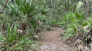
Tunnel deeply into a parade of coastal habitats on this deeply shaded and well-interpreted loop edged by salt marshes along the St. Johns River basin.
Acquired and managed by the North Florida Land Trust, this 96 acre preserve is an important sliver of conservation land amid a growing press of subdivisions along Cedar Point Rd.
 Palm-lined passage
The former homestead of author Sue Spencer, she called it Bugtussle for a good reason. Depending on the season, the mosquitoes descend in squadrons.
Part of the 7 Creeks Recreation Area, it has a landing along Bogey Creek with nearby picnic tables set in the shade.
 Bogey Creek flows into Clapboard Creek
Resources





Disclosure: As authors and affiliates, we receive earnings when you buy through our links. This helps us provide public information on this website.
Overview
Location: Jacksonville Northshore
Length: 1.2 miles
Trailhead: 30.45599, -81.51977
Address: 5500 Cedar Point Rd, Jacksonville
Fees: Free
Restroom: Portable toilet at trailhead
Land Manager: North Florida Land Trust
Phone: 904-479-1967
Open sunrise to sunset. Leashed pets welcome. Expect copious mosquitoes and plan for them before you emerge from your vehicle.
Directions
From Interstate 295 northbound, cross the Dames Point Bridge and take exit 41. Turn right on Heckscher Dr and get in the left lane immediately to make a left at the light onto New Berlin Rd. Drive 3.8 miles to a road junction and bear right onto Cedar Point Rd. Continue 2.6 miles to the preserve entrance on the right, a narrow one lane drive to the trailhead.
Hike
A clearing with an informational kiosk and picnic table adjoins the parking area, the trail starting at the corner with the “All Trails” sign.
Follow the footpath to a sharp turn at a cable gate. It narrows at the approach to the first of a series of large interpretive signs, this one an overview of the preserve’s history.
 Trailhead
The well-shaded footpath becomes a slender causeway across a cypress strand. Inky waters lap at both sides. Cypress knees jut from the footpath.
Reach the loop junction at the interpretive sign for cypress swamps after a tenth of a mile.
 Cypress swamp causeway
It’s called the Bugtussle Loop. Much of the year, both freshwater and saltwater mosquitoes will descend in swarms, hurrying you along this hike.
Turn right to start counterclockwise around the loop. Leaf litter carpets a level footpath under a canopy of oaks and pines.
 A deeply shaded trail
Along with the expected saw palmetto, bluestem palm, with larger and more relaxed fronds (and no sawteeth on its stems) largely define the trail corridor.
A few older saw palmetto have trunks rising from the forest floor. The forest canopy heightens, both oaks and pines towering above.
 Cushy pine duff footpath
At another cable gate, the trail turns, becoming a broad carpet of pine duff in mesic flatwoods, as the interpretive sign points out.
This straight, shaded corridor meets the Landing Trail at 0.3 mile. At the signpost, continue straight ahead.
 Trail junction
Follow the Landing Trail beneath the moss-draped oaks of the maritime hammock to a split in the path. Either side leads to its showy conclusion, the salt marsh at Bogey Creek.
A tiny sand beach is adjoined by a picnic table in the clearing under the oaks, with interpretive information on the habitat in front of you.
 Interpretive sign at the landing
Returning to the Bugtussle Loop, make a right. Pignut hickories drop their bounty on the leaf-strewn footpath, which narrows into a tight squeeze between palm fronds.
Pines and cypress rise beyond the sea of palmettos. Deeper shade envelopes the path under a tight-knit canopy of oaks and magnolia.
 Back on the bugtussle Loop
Light filtering in from the right marks how close the salt marsh is, but the trail doesn’t touch it again. Curve sharply away from the 7 Creeks basin at 0.8 mile.
A former side trail to the marsh is blocked off with an arrow marker pointing right and left.
 Old side trail
Palmettos crowd in on the approach to the next cable gate, the Bugtussle Loop making a 90-degree turn in front of it.
Follow the edge of a fence a mile into the hike, where a soft carpet of pine needs makes the walk easy.
 Fenceline walk
On the approach to the cypress swamp, the trail is again in the flatwoods, lined by palmetto. Complete the loop at the signpost for the trailhead.
Make a right to cross the causeway through the cypress swamp, watching out for cypress knees in the footpath. Return to the trailhead, finishing the hike after 1.2 miles.
 Cypress swamp
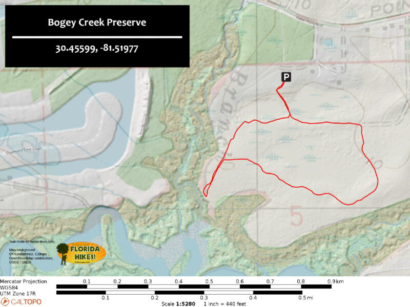
Trail Map
Explore More!
Video
A walk through Bogey Creek Preserve
Slideshow
See our photos from Bogey Creek Preserve
Nearby Adventures
 Pumpkin Hill Creek Preserve State Park Within city limits yet truly wild, Pumpkin Hill Creek Preserve State Park protects more than 4,000 acres along the edges of enormous estuaries draining into the St. Johns River.
 Betz-Tiger Point Preserve On a peninsula where the Timucua used the surrounding estuary for sustenance, Betz-Tiger Point Preserve provides more than six miles of breezy trails.
 Yellow Bluff Fort Historic State Park Site of a Civil War encampment, this strategic defensive position along the St. Johns River has been reclaimed by a canopy of ancient oaks.
 Fairway Loop Trail Showcasing a slow restoration to maritime forest, this uplands loop on Fort George Island traverses what remains of a 1920s-era Scottish-style golf course near Jacksonville.

- Michael Crotty Bicentennial Park - November 3, 2026
- A.J. Henry Park - November 1, 2026
- Okeeheelee Nature Center Trails - October 22, 2026