

With more than 23 miles of oceanfront, this massive national park stretches across two counties, encompassing a large expanse of the Indian River Lagoon and its islands between Titusville and New Smyrna Beach.
Edging Merritt Island National Wildlife Refuge, it includes lands managed by NASA as a buffer zone for the Kennedy Space Center as well as popular Playalinda Beach, which shares a boundary with the edge of space.
The unique location of Canaveral National Seashore makes it the northernmost point for many tropical plants to thrive. It is also a major stopover point for migratory birds in fall and spring.
 View north from Turtle Mound
Resources





Disclosure: As authors and affiliates, we receive earnings when you buy through our links. This helps us provide public information on this website.
Overview
Location: New Smyrna Beach, Oak Hill, and Titusville
Land Manager: National Park Service
Phone: 386-428-3384
Access to the Apollo Beach (New Smyrna Beach) and Playalinda Beach (Titusville) units of Canaveral National Seashore costs $25 per vehicle. There is no charge to visit Seminole Rest.
If you have a National Parks/Interagency Pass, it covers all fees. All three units are open sunrise to sunset.
Dogs are not permitted on any of the beaches, on beach crossover boardwalks, at Seminole Rest, or on the boardwalk at Turtle Mound. They are welcome on the lagoon-side trails and beaches.
Directions
Use this map to determine which of the units of Canaveral National Seashore you plan to visit. Clicking on an icon will take you to information for that specific location.
Directions to Apollo Beach
The northernmost unit is Apollo Beach. From Interstate 95 in New Smyrna Beach, follow SR 44 east, crossing US 1 and the Indian River Lagoon. Past S. Peninsula Avenue, continue 8 miles along A1A to the park entrance gate. The Visitor Center, trailheads, and beach parking are along this 6.4-mile dead-end piece of A1A inside the park.
Directions to Seminole Rest
From Interstate 95 south of New Smyrna Beach, take the Scottsmoor exit, located between Edgewater and Mims. Drive briefly east to meet US 1. Turn north and drive to Oak Hill. Signs will point you east to River Road. The parking area is on the right at a large National Park sign immediately after a sharp left turn in front of a campground.
Directions to Playalinda Beach
From Interstate 95 in Titusville, take SR 406 (Garden Street) east through town. After you cross US 1 and the Max Brewer Memorial Bridge over the Indian River Lagoon, keep right at the fork as you enter Merritt Island National Wildlife Refuge. Signs guide you straight ahead towards Playalinda Beach.
Visiting Canaveral National Seashore
Since Canaveral National Seashore is so vast, much of it is wild. This includes nearly 12 miles of oceanfront known as Klondike Beach, the most remote shoreline in Florida on the Atlantic Coast.
Nearly 20 miles of wide-open shallow flats, spoil islands – piled up in the flats when the Intracoastal Waterway was dredged – and natural mangrove islands are a part of the North Indian River Lagoon, also known as Mosquito Lagoon.
It’s here that paddlers and boaters can get away from it all on island campsites under starry skies.
Three markedly different units define this National Seashore. From north to south, they are the Apollo Beach Unit in New Smyrna Beach, Seminole Rest in Oak Hill, and Playalinda Beach in Titusville. Each has its own set of recreation activities and landscapes with stories to tell.
Apollo Beach
While the beaches of the Apollo Beach Unit have attracted visitors for decades, it’s here you’ll find the most places to explore the seashore on a trail.
You can paddle a marked trail through Shipyard Island, a large island in the lagoon within sight of Turtle Mound, or follow the shoreline of this barrier island from any of four launches on the lagoon.
 Several piers front the lagoon
Just inside the park gates, a parking area on the right provides access for boaters and paddlers to the Indian River Lagoon. Boat trailer parking adjoins vault toilets near the boat ramp.
A small picnic area tops a rise next to the parking area for other vehicles. Across the road is Beach Access 1, the first of five small parking areas along the dunes fronting the Atlantic Ocean.
 Boat ramp across from Shipyard Island
Immediately south of this point is Turtle Mound, the most popular short trail in the park. Defined by an entrance boardwalk, it’s easy to spot next to the parallel parking spaces.
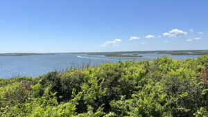 Turtle Mound At Canaveral National Seashore, savor an outstanding Atlantic Coast panorama from atop 1.5 million bushels of oyster shells piled up more than a thousand years ago.
Apollo Beach Visitor Center
From the display panel outside the front door, it’s obvious the “Apollo” in this beach refers to the trips to the moon launched south of here at Cape Canaveral a half-century ago.
While it feels improbable from this perspective, this narrow strip of barrier island is physically connected to where astronauts still launch today, just south of Playalinda Beach.
Displays inside the Visitor Center delve into the natural and cultural history of this national park. A theater provides an overview film, and the gift shop is stocked with keepsakes and books about the region.
Sharing the same parking lot, a hand launch for paddlers adjoins a picnic pavilion and pier on the lagoon, along with rental kayaks.
 Inside the Visitor Center
Eldora Loop Road
Eldora Loop Road swings off Apollo Beach Road as a one-way drive south. A stop at the first parking area leads to a hand launch for paddlers at its north end.
At the other end of the same parking area, a well-worn footpath winds through the hammock to a clearing with a picnic table and quiet fishing pier on the lagoon.
 Launch at the north end of the Eldora Loop Road
The next two parking areas offer access to short interpretive walks. Don’t miss the Eldora State House.
Visit this historic coastal home and museum to learn all about the community that once thrived along these shores.
 Eldora Village Settled in the late 1800s south of New Smyrna, Eldora thrived as a rural agricultural community for more than a decade. Today, the Eldora State House tells its story.
 Eldora Hammock Trail Near the ghost town of Eldora, the Eldora Hammock Trail loops through the beauty of a lush coastal hammock, highlighting a semi-tropical understory in deep shade.
South of Eldora
Three beach access points and two trails await at the remote south end of Apollo Beach Road. Parking Area 3 provides access to the showy Castle Windy Trail not far south of Eldora.
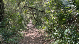 Castle Windy At Canaveral National Seashore, Castle Windy is the only trail that takes you from the Atlantic Ocean to the Indian River Lagoon, a shady walk through a coastal hammock to a windswept shoreline.
The road culminates in a turnaround. Before Kennedy Space Center existed, the road went through to Merritt Island.
 Southernmost launch point into the lagoon
Signs warn of nude bathers at Parking Area 5, the southernmost access to the beach and the north end of Klondike Beach.
This 12.8 mile walk along Florida’s most remote stretch of Atlantic shoreline connects to a similarly popular beach at Playalinda Beach, the southernmost unit of this seashore in Titusville.
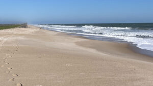 Klondike Beach Along a thin slice of dunes bordered by the Atlantic Ocean and the Indian River Lagoon, Klondike Beach is one of Florida's longest stretches of undeveloped coastline.
A shorter option at Klondike Beach is a round-trip of up to 9 miles along the Indian River Lagoon side of the dunes on the old highway perched above the scenery.
 Narrow strip of oceanfront at Apollo Beach
Seminole Rest
Lesser known than its sister units, Seminole Rest is a small site with a deep history. A shell mound several millennia old rises from the edge of the Indian River Lagoon, with a historic home from the late 1800s atop it.
You can paddle in and out of the beach at Seminole Rest to explore both the community of Oak Hill and the wild shorelines that stretch south towards Merritt Island.
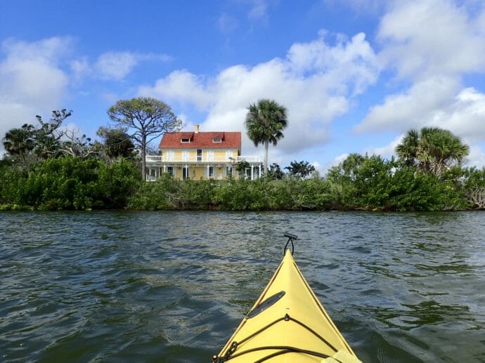 Seminole Rest The accessible Seminole Rest Trail interprets a historic and archaeological site at Canaveral National Seashore along the shores of the Indian River Lagoon.
Playalinda Beach
If you want to see a rocket launch up close and personal, Playalinda Beach is the place to go. Beach Access 1 is literally separated from Kennedy Space Center by a fence.
Visitors crowd the beach to see launches at Pad 39A, which is the go-to launch site for all SpaceX rockets including the Falcon Heavy.
In addition to miles of renowned beaches, Playalinda offers anglers and paddlers a place to play at Eddy Creek. Birders will appreciate the extensive salt pond flats where roseate spoonbills are frequent visitors.
 Playalinda Beach At the south end of Canaveral National Seashore, Playalinda Beach is a popular destination for beachgoers along the Space Coast thanks to its natural beaches and views of Kennedy Space Center.
Explore More!
Articles about Canaveral National Seashore
 Celebrate National Park Week (1/9/2024) Enjoy a week-long nationwide celebration of America's National Parks in 2024, starting with fee-free admission on Saturday April 20. Get outdoors and explore Florida's National Parks.
 Hiking Safely With Your Dog (5/11/2019) While hiking with your dog can be very satisfying, Florida hiking has its own special perils for your best buddy. Here's a heads-up on what to look for and where it's best to take a hike.
 A Paddle I Will Never Forget (3/1/2019) Taking on a remote stretch of the Indian River Lagoon paralleling the wildest part of Canaveral National Seashore, our group of paddlers turns back until only two kayakers are left, fighting the wind to reach our goal.
 Every Kid Outdoors (2/21/2019) Got kids? If any of them are in fourth grade, they can get a free pass to ALL Federal public lands good for the whole family through the end of August. Here's how.
 Reflections on the National Park Centennial (8/29/2016) Reflections on our National Parks during the Centennial celebration this week, with a wander through Canaveral National Seashore in both New Smyrna Beach and Titusville

- Hal Scott Red Trail - November 13, 2026
- Baseline Trails - November 7, 2026
- Hal Scott Yellow Trail - November 3, 2026