• Skip to main content
  • Skip to header right navigation
  • Skip to after header navigation
  • Skip to site footer
Florida Hikes logo

Florida Hikes

Hike Bike Paddle Camp Florida with authors Sandra Friend and John Keatley as your guides

  • Trails
  • Maps
  • Guidebooks
  • Hike
    • Scenic Hikes
    • Loop Trails
    • Dog-friendly Hikes
    • Hikes for Kids
    • National Parks in Florida
    • Florida State Parks
  • Bike
    • Major Bike Trails
    • Paved Bike Trails
    • Off Road Biking
    • Biking Articles
  • Paddle
    • Canoe & Kayak Rentals
    • Paddling Destinations
    • Paddling Articles
  • Camp
    • Cabin Rentals
    • Car Camping
    • Primitive Camping
  • Florida Trail
    • Plan your Hike
    • Best Scenic Hikes
    • Best Backpacking
    • Section Hiking
    • Thru-Hiking
    • Trail Updates
  • Travel
Cady Way Trail sign

Cady Way Trail

An urban bike path, the Cady Way Trail follows an old railroad line to connect Orlando and Winter Park neighborhoods to neighboring Seminole County.

Orlando (28.6101, -81.2840)   7.5 miles  

Following the former Southern Coast Line (SCL) route into urban Orlando, the Cady Way Trail is a utilitarian bike path, mostly in its own greenway.

It connects neighborhoods and parks together in Audubon Park, Baldwin Park, Winter Park, and Goldenrod.

And it connects all of these residents with the Orlando Fashion Square Mall. No need to ride along roads in this busy area.

Much of the route is either behind industrial parks or behind subdivisions in an urban greenway corridor.

It is nicely shaded in the residential areas, and less so in the industrial areas.

Cady Way Trail Riding through a Winter Park neighborhood


There are many road crossings, making this more of a transportation corridor and less of a recreation corridor.

For recreation users, the Cady Way Trail opens a portal to a vast amount of mileage on Seminole County’s trails. Follow it east to connect to the Cross Seminole Trail.

Cady Way Trail Greenway through an industrial park


Resources

Resources for exploring the area
50 Hikes in Central Florida Central Florida Orlando Explorers Guide book cover Hikers Guide to the Sunshine State book cover Paddlers Guide Florida
 
Disclosure: As authors and affiliates, we receive earnings when you buy through our links. This helps us provide public information on this website.

Overview

Location: Winter Park and Orlando
Length: 7.5 miles linear
Land manager: Orange County
Address: 821 Herndon Ave, Orlando
Phone: 407-254-9025

Open sunrise to sunset. Leashed dogs welcome. Water fountains and benches are along the trail. Shade is limited in some places.

This is an urban bike path. Be alert to your surroundings for your personal safety. Do not leave your gear unattended or your bike unlocked when out of sight of it.

There are many places along the trail with benches, as well as some water fountains and trash cans. Restrooms are only at the trailheads.

While portions of the route are in a protected greenway, there are numerous road crossings with heavy traffic. Most, but not all, have traffic lights to assist in crossing.

Cady Way Trail Trail amenities include benches, water fountains, and trash cans


Emergency Response Markers are set in the asphalt every 1/10 mile. Use these to reference your position if you call 911 or law enforcement.

Cady Way Trail Taking a break on the Semoran Blvd bridge


Trail Details

We rode the Cady Way Trail after finishing the southern portion of the Cross Seminole Trail, as they connect together seamlessly just west of Hall Rd.

Cady Way Trail Riding along Aloma Blvd


A quarter mile from the eastern terminus of the trail at the county line, Goldenrod Park is the nearest place you can park along the trail.

Goldenrod Park John consulting the trail map at Goldenrod Park


It has a kiosk with trail map as well as some benches and restrooms. After the park, there is a road crossing at Goldenrod Rd.

The next stretch up to Palmetto Avenue is edged by retail businesses along Aloma Ave. The green space at Perch Lake makes up for it, with a gazebo for a rest stop.

Cady Way Trail Perch Lake Perch Lake Overlook


Palmetto Ave (SR 551) can be very busy and there is no light for cyclists. Be cautious crossing this four-lane road. There is a median to pause in.

Cady Way Trail Palmetto Avenue crossing


Enter a greenway corridor beyond Palmetto Ave. At first it is shaded and then it is flanked by industrial parks and businesses.

Cady Way Trail Riding through an industrial park


A bridge crosses a channelized waterway draining from Lake Howell to the Econlockhatchee River.

Flanked by chain link fences, the surroundings are very urban, moreso than any of the other trails we’ve ridden in this region.

Cady Way Trail Riding through an urban setting


Forsyth Rd is the next road crossing and it can be even tougher than Palmetto Ave to cross because of all the industrial truck traffic. It also has a bike-width median.

Riding along industrial parks isn’t that exciting. But the scenery changes as you climb up and over SR 436 (Semoran Blvd) on a large bridge into residential Winter Park.

Cady Way Trail BridgeComing up to the bridge over Semoran Blvd


After you cross Ranger Rd, the character of the ride changes. An urban forest shades the route.

Cady Way Trail Starting through Winter Park


Making a curve south, the the trail heads down a corridor that feels more green. The second trailhead, Cady Way Trail, is soon after the curve.

Cady Way Trail Shaded corridor with lots of space


Road crossings are less frequent and involve neighborhood streets. Adjoining Winter Pines Golf Club for a stretch, the trail comes up to Baldwin Park Street.

Baldwin Park Crossing Baldwin Park Street


There is a side path here leading west after the road crossing. It goes to the Lake Baldwin Trail, where there is a 2.5 mile loop around Lake Baldwin with no road crossings.

The Cady Way Trail continues south, paralleling Truman Rd past Baldwin Park. After several residential road crossings, the trail curves west through a forested area.

Cady Way Trail Curve through a forest


By 5.8 miles, it meets Lake Baldwin Lane. The north-south side path along this road is also part of the Lake Baldwin Trail, connecting to the lake loop to the north.

Baldwin Park Junction with Lake Baldwin Trail/>

Turn south (left) and cross Lake Baldwin Lane just before you get to Roush Ave. The Cady Way Trail continues west, paralleling Roush.

Cady Way Trail The Cady Way Trail crosses Lake Baldwin Lane here


The trail slips around a pretty view at Lake Gear before reaching Bennett Rd, another busy street to cross.

Slipping between the FedEx warehouse and the big Post Office on Herndon Ave, it makes a sharp turn up along McCullough Ave to reach Maguire Blvd at 6.6 miles.

Here, the trail is a broad side path leading west. Turn left and follow it around Fashion Square Mall.

Cross Maguire at the traffic light at Woodcock Rd. The side path now stays north of Maguire until it turns to parallel Warehouse Rd north.

Turn left for one last road crossing as the trail continues west up a utility easement to reach the entrance to Lake Druid Park. It ends after 7.5 miles.

ALT Riding through residential Orlando


Trailheads


Goldenrod Park, 4863 N Goldenrod Rd, Winter Park
Cady Way Park, 2525 Cady Way, Winter Park
Lake Druid Park, 899 Coy Dr, Orlando

Cady Way Park Trailhead at Cady Way Park


Mileage

0.3, Goldenrod Park
2.6, Cady Way Trailhead
4.1, Baldwin Park Trail Connector
6.4, Herndon Ave
7.5, Lake Druid Park


Connections

Cross Seminole Trail

The eastern terminus of the Cady Way Trail segues right into the Cross Seminole Trail at Hall Rd. Cross Hall and Aloma at the traffic light.

Cross Seminole Trail under SR 417 Cross Seminole Trail West Connecting to the Cady Way Trail, the western leg of the Cross Seminole Trail enables cyclists to ride from Oviedo into Orlando.

Follow the Cross Seminole Trail bike path east for 6.6 miles to reach Oviedo to connect to the greater network of trails in Seminole County.

Cross Seminole Trail Cross Seminole Trail passing under SR 417


Lake Baldwin Trail

From the Cady Way Trail, there are two connections to the Lake Baldwin Trail. The first is a side path at Baldwin Park Street. The second is at Lake Baldwin Lane.

The Lake Baldwin Trail includes a 1.7 mile loop around Lake Baldwin and a 0.9-mile linear side path paralleling Baldwin Park Blvd.

Lake Baldwin Orlando Lower loop junction around Lake Baldwin


Trail Map
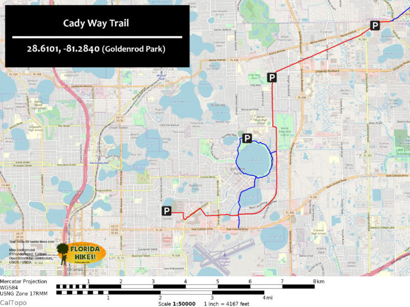
Cady Way Trail map
Cady Way Trail in red, Lake Baldwin Trail in blue

Explore More!

Nearby Adventures

Pond surrounded by spring green on trees Mead Botanical Garden Established as a camellia showcase, this public garden has a nature trail first built in 1956 to explore natural habitats within a 47-acre urban forest.
Path through tropical gardens Harry P. Leu Gardens Fifty acres of formal gardens hug Lake Rowena in this historic display of botanical diversity in Orlando.

Trail Guide (PDF) Official Website

  • Author
  • Recent Posts
Sandra Friend & John Keatley
Articles jointly researched, written, and photographed by Sandra Friend & John Keatley, authors and publishers of FloridaHikes.com.
Sandra Friend & John Keatley
Latest posts by Sandra Friend & John Keatley (see all)
  • Hal Scott Red Trail - November 13, 2026
  • Baseline Trails - November 7, 2026
  • Hal Scott Yellow Trail - November 3, 2026
Category: Biking, Central Florida, County Parks, Day Hikes, Hikes, Paved Bike Trails, TrailsTag: Dog-friendly, Orlando, Winter Park

Sidebar

FarOut Guides

Our comprehensive trail logistics presented on offline maps:

Florida National Scenic Trail (1,500 miles)
Florida Keys Overseas Heritage Trail (108 miles)
Eastern Continental Trail in Florida (92 miles)


We earn a small commission on sales through these links. Thanks for your support!


Our Florida Guidebooks

We’ve written Florida guidebooks for over 25 years. These include Central Florida destinations.

Book cover with woman hiking through palms with baby carrier
Book cover of Florida Trail Hikes
The Florida Trail Guide fifth edition
50 Hikes in Central Florida 3rd edition

Explore More

Newest Articles for Central Florida

Path through pine flatwoods Hal Scott Red Trail
Grassy slope edged with trees Sandhill Preserve
Two-track through pine savanna Hal Scott Yellow Trail
Footpath through coastal hammock Michael Crotty Bicentennial Park

  • Facebook
  • Flickr
  • Instagram
  • Pinterest
  • Substack
  • Vimeo

FIND A TRAIL OR PARK

METROS: Bradenton. Clearwater. Crestview. Daytona Beach. Destin. Fort Lauderdale. Fort Myers. Fort Walton Beach. Gainesville. Jacksonville. Kissimmee. Lakeland. Melbourne. Miami. Naples. Ocala. Orlando. Panama City Beach. Pensacola. Port St. Lucie. Punta Gorda. St. Petersburg. Sanford. Sarasota. Sebring. Stuart. Tallahassee. Tampa. Vero Beach. West Palm Beach.

MULTI-REGION: Atlantic Coastal Ridge. Atlantic Coast. Bartram Trail. Big Bend. East Coast Greenway. Everglades National Park. Florida National Scenic Trail. Gulf Coast. Lake Wales Ridge. WATERWAYS: Indian River Lagoon. Intracoastal Waterway. Kissimmee River. St. Johns River. Withlacoochee River.

NORTHWEST FLORIDA: Altha. Apalachicola. Apalachicola National Forest. Big Bend Scenic Byway. Blackwater River State Forest. Blountstown. Bonifay. Bristol. Bruce. Cantonment. Cape San Blas. Carrabelle. Chattahoochee. Chipley. Crawfordville. DeFuniak Springs. Eastpoint. Ebro. Eglin Air Force Base. Freeport. Fountain. Gulf Breeze. Gulf Islands National Seashore. Holt. Madison. Marianna. Milton. Monticello. Mossy Head. Munson. Navarre. Navarre Beach. Newport. Niceville. Panacea. Panama City . Perdido Key. Ponce De Leon. Port St. Joe. Quincy. Santa Rosa Beach. Sopchoppy. South Walton. St. George Island. St. Marks. St. Marks NWR. Sumatra. Vernon. Wakulla. Wewahitchka. Woodville. WATERWAYS: Apalachicola River. Blackwater Bay. Blackwater River. Chipola River. Choctawhatchee Bay. Choctawhatchee River. Coastal Dune Lakes. Ochlockonee Bay. Perdido River. St. Marks River. Wacissa River. Wakulla River. Yellow River.

NORTH FLORIDA: Alachua. Amelia Island. Archer. Baldwin. Branford. Bronson. Bunnell. Callahan. Cedar Key. Chiefland. Crescent City. Cross City. Cross Creek. Dowling Park. Ellaville. Fanning Springs. Fernandina Beach. Flagler Beach. Fort White. Glen St. Mary. Green Cove Springs. Hawthorne. High Springs. Inglis. Jacksonville Beaches. Jacksonville Northshore. Jasper. Jennings. Keystone Heights. Lake Butler. Lake City. Live Oak.Macclenny. Mandarin. Mayo. Mayport. Micanopy. Middleburg. Old Town. Olustee. Orange Park. Osceola National Forest. Palatka. Palatka-Lake Butler Trail. Palm Coast. Palm Valley. Perry. Ponte Vedra. Rodman. Salt Springs. St. Augustine. Starke. Steinhatchee. Suwannee. Suwannee River Wilderness Trail. Suwannee Springs. Talbot Islands. Timucuan Preserve. Trenton. Waldo. Welaka. White Springs. Williston. Worthington Springs. Yankeetown. WATERWAYS: Santa Fe River. St. Marys River. Suwannee River. Tolomato River. Upper Withlacoochee River.

CENTRAL FLORIDA: Altamonte Springs. Apollo Beach. Apopka. Astatula. Astor. Auburndale. Bartow. Babson Park. Bayport. Belleview. Bithlo. Brandon. Brooksville. Bushnell. Canaveral National Seashore. Cassadaga. Christmas. Chuluota. Citrus Springs. Clearwater Beach. Clermont. Coast to Coast Trail. Cocoa. Cocoa Beach. Cross Florida Greenway. Crystal River. Dade City. De Leon Springs. DeBary. Deland. Deltona. Dunedin. Dunnellon. Edgewater. Enterprise. Eustis. Ferndale. Fort Meade. Frostproof. Geneva. Gibsonton. Haines City. Hernando. Hernando Beach. Holopaw. Homosassa. Inverness. Kenansville. Kissimmee. Lake Mary. Lake Wales. Largo. Leesburg. Lithia. Longwood. Lutz. Maitland. Malabar. McIntosh. Melbourne Beach. Merritt Island. Merritt Island NWR. Mims. Mount Dora. Narcoossee/Lake Nona. New Port Richey. New Smyrna Beach. Nobleton. Oak Hill. Oakland. Ocala National Forest. Ocklawaha. Ocoee. Oldsmar. Orange City. Ormond Beach. Osteen. Oviedo. Paisley. Palm Bay. Plant City. Poinciana. Polk City. Ponce Inlet. Port Orange. Ridge Manor. Riverview. Ruskin. Safety Harbor. Silver Springs. Sorrento. Spring Hill. St. Cloud. Tarpon Springs. Thonotosassa. Titusville . Umatilla. Viera. Walt Disney World. Weeki Wachee. Weirsdale. Wimauma. Windermere. Winter Garden. Winter Haven. Winter Park. Winter Springs. Withlacoochee State Forest. Withlacoochee State Trail. Yeehaw Junction. Zephyrhills. WATERWAYS: Alafia River. Halifax River. Hillsborough River. Lake Apopka. Little Manatee River. Ochlawaha River. Rainbow River. Tampa Bay. Wekiva River. Wekiva River Basin.

SOUTHWEST FLORIDA: Alva. Boca Grande. Cape Coral. Charlotte Harbor. Ding Darling NWR. Ellenton. Englewood. Estero. Immokalee. Marco Island. North Port. Osprey. Palma Sola. Palmetto. Pine Island. Port Charlotte. Sanibel Island. Venice. WATERWAYS: Caloosahatchee River. Manatee River. Myakka River. Pine Island Sound.

SOUTH FLORIDA: Arcadia. Basinger. Big Cypress National Preserve. Big Cypress Seminole Reservation. Big Cypress Swamp. Bowling Green. Clewiston. Everglades City. Indiantown. LaBelle. Lake Okeechobee Scenic Trail. Lake Placid. Lakeport. Moore Haven. Okeechobee. Ortona. Pahokee. Palmdale. Port Mayaca. South Bay. Wauchula. Zolfo Springs. WATERWAYS: Fisheating Creek. Lake Okeechobee. Peace River.

SOUTHEAST FLORIDA: Biscayne Bay. Biscayne National Park. Boca Raton. Boynton Beach. Coconut Creek. Coral Gables. Coral Springs. Davie. Delray Beach. Fellsmere. Flamingo. Fort Pierce. Hobe Sound. Hollywood. Homestead. Indrio. Jensen Beach. Juno Beach. Jupiter. Jupiter Farms. Key Biscayne. North Hutchison Island. Ocean to Lake Greenway. Palm Beach. Palm Beach Gardens. Pompano Beach. Redland. Sebastian. South Hutchinson Island. WATERWAYS: Florida Bay. St. Lucie River.

FLORIDA KEYS: Big Pine Key. Islamorada. Key Largo. Key West. Marathon. Overseas Heritage Trail.


©2006-2026, Sandra Friend & John Keatley | Disclosure | Site Index | Work with Us | Advertise with Us | Terms of Service and Privacy Policy

Florida Hikes PO Box 93 Mims FL 32754 | Contact
