
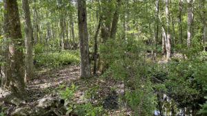
Protecting over 5,300 acres of land within the St Johns River watershed, Deep Creek Preserve is divided into two distinct tracts along its namesake waterway.
Though a large portion of the Yarborough Tract was once agricultural land, the North Tract encompasses a wild swath of wetlands.
A small corner of the North Tract parcel is composed of upland communities, where a well-marked trail showcases boggy baygalls and verdant pine prairies.
 Among the oaks
Resources



Disclosure: As authors and affiliates, we receive earnings when you buy through our links. This helps us provide public information on this website.
Overview
Location: Elkton
Length: 2.8 miles
Trailhead: 29.782583, -81.491917
Address: 3725 CR 13 S, Elkton
Fees: Free
Restrooms: None
Land manager: St Johns River Water Management District
Phone: 386-329‑4500
Open 24 hours, leashed dogs welcome.
Directions
From Interstate 95 south of St. Augustine, head southwest on SR 207 for 6.3 miles before turning right onto Don Manuel Rd. In 1.3 miles, make a right onto SR 13. Continue south for 1.2 miles. The trailhead is on the left side of the road.
Hike
Starting at the trailhead parking area, walk down the forest road for a tenth of a mile to an information kiosk with trail maps.
Red diamonds mark the route as a wide pathway curves westward to cross over a baygall habitat.
 Trailhead gate
Culverts allow water to pass under the road where a dense canopy of bay and sweetgum stands above dark soil covered in a multitude of ferns.
On the other side, a slight rise in elevation brings a transition to oaks and sporadic pines.
 Wetland crossing
The trail bends southward, bordered by a dense assortment of saw palmetto, gallberry, and wax myrtle.
Spindly ladies-tresses orchids bloom at the edges of the grassy access road, alongside orange milkworts and pink mimosa blossoms.
 Orchids in bloom
Reaching the loop portion of the trail at 0.9 mile, continue straight, following red blazed pines deeper into the forest.
In another quarter mile, take a sharp right turn to leave the road, venturing into an increasingly wet environment on a narrower pathway.
 Blazed pine tree
Bay trees rise overhead as the corridor dips into a swampy stretch likely to hold water after heavy rain.
As the trail heads northward, it traces alongside primordial wetlands before emerging into a mesic flatwoods habitat.
 Flooded trail
A sea of native shrubs thrives in this sun-drenched savanna maintained with periodic fire, evidenced by charred pines with healthy, leaf covered crowns.
At 1.9 miles, the loop portion ends at the approach trail, leaving a pleasant 0.9 mile walk back to the trailhead.
 Pine flatwoods
Trail Map

Explore More!
Video
Hiking Deep Creek Conservation Area North
Nearby Adventures
 Palatka to St. Augustine Trail Connecting two of North Florida's most historic cities, the Palatka to St. Augustine Trail follows the route of Henry Flagler's East Coast Railway through rural farming communities.
 Welaka State Forest Protecting over four miles of forested waterfront on the St. Johns, Welaka State Forest offers a glimpse of what botanists John and William Bartram saw in the 1700s.
 Shell Bluff Park Walk beneath an unbroken hardwood canopy evocative of Old Florida on the well-maintained pathways of rural Shell Bluff Park near Crescent Lake.
 Moses Creek Conservation Area Follow a system of wide trails across pine forests, hammocks, scrub, and sandhill habitats to a scenic overlook and campsite along tidally-influenced Moses Creek.

- Oscar Scherer Green Trail - November 11, 2026
- Sandhill Preserve - November 9, 2026
- Calusa Heritage Trail - November 5, 2026