

A pleasant ramble along the Withlacoochee River, the Croom River Trail segment of the Florida Trail stretches 6.3 linear miles.
The southern section starts near river level, eventually climbing onto bluffs. Tunnel through oak hammocks and slip past cypress swamps while marveling at massive trees.

Our Florida Trail Books & Guides


Disclosure: As authors and affiliates, we receive earnings when you buy through our links. This helps us provide public information on this website.
Overview
Location: Ridge Manor
Length: 6.3 miles linear
Trailhead: 28.526758, -82.218781
Fees: Free
Restroom: At the Ridge Manor and Crooked River trailheads
Land manager: Florida Forest Service
Phone: 352-797-4140
Leashed dogs welcome. Day use only. Camping at designated campgrounds (Crooked River, Cypress Glen, Silver Lake) must be reserved in advance.
Check river levels before attempting this section as the south end of this trail will be swamped by high water on the Withlacoochee River.
Check on hunting seasons before hiking. Wear bright orange during hunts.
Directions
28.565763, -82.207488
28.526758, -82.218781
28.563416, -82.22015
Take Interstate 75 exit 301 for SR 50 east towards Ridge Manor. Drive a mile to the light at Croom-Rital Road and turn left. The southern trailhead is on the right after a quarter mile. The northern trailhead is roughly 2.5 miles north at the Croom Trail sign and trail crossing.
Hike
From the sign-in at the Ridge Manor trailhead — and the number of people we encountered — this is a popular piece of the Florida Trail for good reason.
Access is near Interstate 75, the views are fabulous, and you can camp right along it at beautiful Crooked River Campground.
It’s a favorite of Scout troops for a merit badge hike. It’s also one of the hikes that qualify for the Florida State Forests Trailwalker Program.
To find the southern terminus of this hike, walk past the picnic area on the opposite side of the Withlacoochee State Trail from the parking area and restrooms at Ridge Manor trailhead. Look for the fence and a trail kiosk under the big oak tree.

The hike starts off in a mature stand of planted pines before the landscape opens up.
After you pass the side trail for the Croom River Trail Loop (Blue Loop Trail sign), continue along the main footpath.
It joins up with the Florida Trail coming in from the south through a gate in a subdivision off SR 50. You may not notice the merger of trails, but you will notice the long tunnel under the oaks.

The straightaway ends at the river bluffs, where the trail turns upriver. Walking along the bluffs, you catch glimpses of the river through the trees.
A bench provides a perch at a nice river bend before you reach the second junction with the Blue Loop after 2.2 miles.

Continue along the orange blazes, which zigzag through a swampy area before heading back out to the river again.
The trail leaves the river briefly and goes around a pine plantation, resuming its place on the bluffs around 3 miles.

Views are interrupted occasionally by oxbow ponds with cypresses. At 4 miles, the trail goes around a swamp with some enormous cypresses.
It leads you under a beautiful canopy of live oaks in order to cross a bridge over a stream.
Returning to the river bluffs, remain there for the next mile, enjoying occasional spots with benches and views.

When the trail turns away from the river, it heads up a straightaway to Crooked River Campground, where there is free trailhead parking.
You can end your hike here after 5.2 miles, or continue past the Cypress Glen turnoff to follow the orange blazes to a trailhead along Croom-Rital Road for a full 6.3 mile hike.
Make a loop back to the Ridge Manor trailhead with a 2.6 mile walk on the paved Withlacoochee State Trail to turn this into a 8.9 mile loop hike.
Southbound / Northbound
 Florida Trail, Cypress Lakes Preserve At Cypress Lakes Preserve, a 1.7-mile segment of the Florida Trail follows the edge of a series of cypress-lined lakes where ancient trees have survived the ages.
 Florida Trail, Croom Hiking Trail 9.8 miles. Traversing rolling landscapes of the Brooksville Ridge, the Croom section of the Florida Trail provides miles of panoramic views within a large area of sandhill habitat.
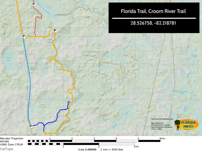
Trail Map
Explore More!
Learn more about the Western Corridor section of the Florida Trail
 Florida Trail, Western Corridor Linking Withlacoochee State Forest and the Cross Florida Greenway, the 241 mile Western Corridor of the Florida Trail accesses wild spaces between Tampa and Ocala.
Learn more about Withlacoochee State Forest
 Withlacoochee State Forest With more than 155,000 acres spread over several counties, Withlacoochee State Forest is Florida’s second largest state forest, and arguably the most popular for outdoor recreation
Slideshow
See our photos from this hike
Nearby Adventures
 Croom Loop C Showcasing elements of a sandhill ecosystem, Loop C in the Croom Tract of Withlacoochee State Forest offers broad views of varied foliage and wildflowers under a sparse canopy.
 Good Neighbor Trail An important link in the Florida Coast to Coast Trail, the Good Neighbor Trail stretches 10.1 miles from downtown Brooksville to the Withlacoochee State Trail.
 Chinsegut Conservation Center Tract Discover the beauty of May's Prairie at the heart of the Chinsegut WEA Conservation Center Tract, a vast wetland where sandhill cranes gather.
 Perry Oldenburg WEA With a surprising diversity of oak species for Central Florida, Perry Oldenburg WEA protects a prime piece of sandhill habitat where gopher tortoises thrive.

- Michael Crotty Bicentennial Park - November 3, 2026
- A.J. Henry Park - November 1, 2026
- Okeeheelee Nature Center Trails - October 22, 2026