• Skip to main content
  • Skip to header right navigation
  • Skip to after header navigation
  • Skip to site footer
Florida Hikes logo

Florida Hikes

Hike Bike Paddle Camp Florida with authors Sandra Friend and John Keatley as your guides

  • Trails
  • Maps
  • Guidebooks
  • Hike
    • Scenic Hikes
    • Loop Trails
    • Dog-friendly Hikes
    • Hikes for Kids
    • National Parks in Florida
    • Florida State Parks
  • Bike
    • Major Bike Trails
    • Paved Bike Trails
    • Off Road Biking
    • Biking Articles
  • Paddle
    • Canoe & Kayak Rentals
    • Paddling Destinations
    • Paddling Articles
  • Camp
    • Cabin Rentals
    • Car Camping
    • Primitive Camping
  • Florida Trail
    • Plan your Hike
    • Best Scenic Hikes
    • Best Backpacking
    • Section Hiking
    • Thru-Hiking
    • Trail Updates
  • Travel
Dense understory along hiking trail in pine flatwoods

Florida Trail, Ocean Pond to Turkey Run

An easy linear hike or round trip with a stop at the Florida Trail’s oldest shelter, this short segment of the Florida Trail in Osceola National Forest is part of the Great Florida Birding Trail.

Osceola National Forest (30.2436, -82.4401)   4.3 miles   Florida Trail, Northeast Florida

This section of the Florida Trail features an immersion in the longleaf pine ecosystem, an increasingly rare habitat with a diversity of endangered plants and animals found nowhere else in the world.

The hike begins with a short boardwalk through a pristine cypress swamp, followed by vast stretches of slash and longleaf pine towering over saw palmetto, ferns, and mosses.

The flat and easy-to-follow path makes for an enjoyable stroll through one of Florida’s most beautiful and ecologically important National Forests.

The Florida Trail’s oldest shelter sits at the northern end of this hike and is a welcome spot for lunch or camping. Non-potable water is accessible from a nearby creek if you bring a water filter.

Saw palmetto in pine flatwoods
Florida Trail in pine flatwoods north of Ocean Pond

Our Florida Trail Books & Guides

Florida Trail Hikes book cover The Florida Trail Guide book cover Florida Trail history book Florida Trail small coffee table book
 
Disclosure: As authors and affiliates, we receive earnings when you buy through our links. This helps us provide public information on this website.


Overview

Location: Sanderson
Length: 4.3 miles linear
Trailhead: 30.2436, -82.4401
Fees: Free
Restroom: Vault toilet at Osceola Shelter
Land manager: U.S. Forest Service, Osceola Ranger District
Phone: 386-752-2577

Open daily sunrise to sunset. Leashed dogs welcome. Foot travel only.

Wear blaze orange during hunting season. Bring bug spray, sunscreen, and water.

Primitive camping is allowed in Osceola National Forest, but random camping is not permitted during the fall deer hunting season.

Easy hiking through sun-dappled pine flatwoods

The Osceola Shelter features 2 picnic tables, fire pit, vault toilet, and room for 3 to 4 tents, as well as a water source (you must filter). Please practice Leave No Trace ethics.

Overnight parking at trailheads is not recommended. When Ocean Pond Campground is open, it has a camp host on duty and it’s best to leave your car there while backpacking this National Forest.


Directions


Heading west on Interstate 10, take exit 324 toward US 90 W. Keep left and follow signs to Olustee/Lake City and turn left onto US 90 W. After 7 miles, turn right onto CR 250A. Continue for 4-miles and you will come to the sign for Ocean Pond Campground. Turn left at the entrance. You will pass the trailhead/Florida Trail in 0.1 miles. Continue another quarter mile to the small parking area on your right.

Hike

From the parking area, walk a quarter mile back along the Ocean Pond Campsite entrance road until you reach the Florida Trail crossing.

Take the trailhead entrance on your left, which heads northwest by compass. The trail is marked with Florida Trail and Great Florida Birding Trail signs.

Hiker walking into woods past trail signs Entering the trail


In 500 feet you will reach a boardwalk crossing over a shadowy cypress swamp replete with its distinctive and mysterious “knees.”

The swamp’s water below is stained by dark tannins while epiphytes above add to an otherworldly environment.

Boardwalk between dense collection of cypress trunks Boardwalk crosses a cypress swamp


Continue on your path following the Florida Trail’s orange blazes until you come out onto FR 241. Take a right and walk to the end of the road.

Sign at FR 241 Double blaze indicates a turn in the trail


Continue your hike through the pine forest with a dense understory of palmetto and scrub. The trail comes back out onto CR 250A again.

Cross the road and you’re back on the trail, where you will come back onto CR 250A for a third time. Take a left, walk 100 feet, and take a right, following the orange blazes back into the woods.

Straight path through pines Long straight path through the forest


In addition to unique flora like the hooded pitcher plant, you may encounter wildlife along your hike, including white-tailed deer, pileated woodpecker, eastern indigo snake, and maybe even a wild turkey.

After crossing CR 250A for the last time, the trail follows a creek to a footbridge. Cross the footbridge, take a right, and you will have reached the Osceola Shelter, the oldest shelter on the Florida Trail.

Turkey tracks in mud Fresh prints of wild turkey


The shelter features two picnic tables, a fire ring, a vault toilet, and a water source, the creek you just crossed. There’s room at the site for 3 to 4 tents.

Continue a half mile north of the shelter and you’ll reach the Turkey Run trailhead, which has ample room for parking.

Open sided shelter with roof and picnic table The Osceola Shelter


For a linear hike, drop a car at the Turkey Run trailhead for a linear hike between parking spots or have someone pick you up here.

Or you can turn around and hike back to Ocean Pond to double your fun for an 8.6 mile day hike.

Trailhead sign in front of pine forest Turkey Run Trailhead


Northbound

Pine flatwoods orange blaze and footpath Florida Trail, Turkey Run to Deep Creek In the northwest corner of Osceola National Forest, this 11.4 mile segment of the Florida Trail offers strong contrasts between pine flatwoods and bogs.

Suggested Articles

Planning tools for the Florida Trail Plan your Florida Trail Hike Thinking of section hiking, thru-hiking, or simply backpacking the Florida Trail? Plan ahead with this step-by-step guide of what to do in advance of hiking the Florida Trail.
Hiking trail with backpack in foreground Florida Trail Backpacking Backpackers will appreciate the many places the Florida Trail provides a pleasant overnight, three-day-weekend, or multi-day hiking experience to escape to the outdoors.
Woman with daypack walking along ocean Section Hiking the Florida Trail Section hiking the Florida National Scenic Trail provides some logistical challenges, but a sense of satisfaction in being able to complete an 1,100-mile walk across Florida at your own pace.
Tents pitched in a clearing in a tropical forest Thru Hike the Florida Trail A thru-hike in Florida takes sixty to ninety days across a surprising diversity of landscapes not found on other long distance trails in the United States.

Trail Map
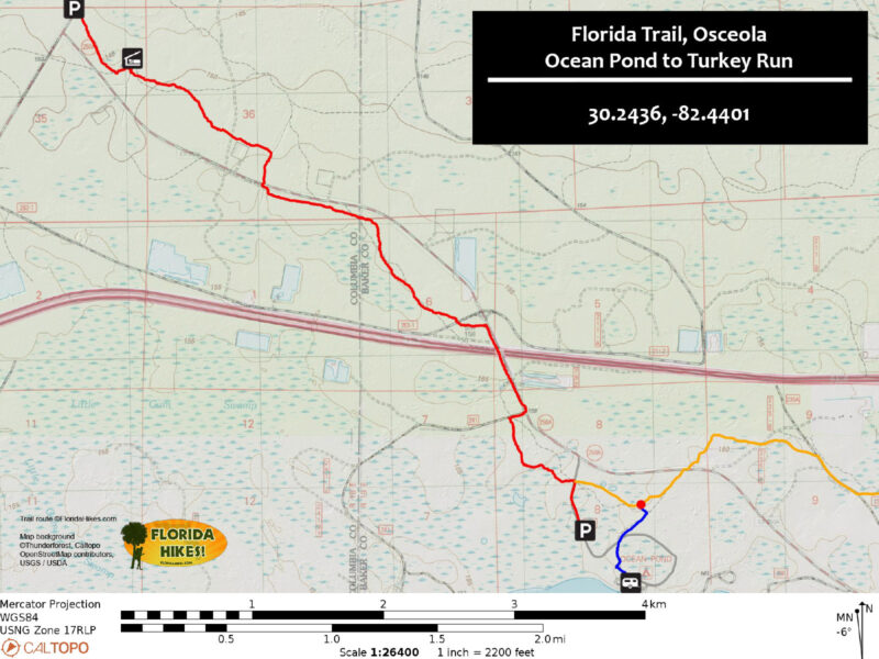
FT Ocean Pond to Turkey Run Trail Map
Red: route described. Orange: Florida Trail southbound. Blue: side trail.

Explore More!

Learn more about Osceola National Forest and the Northeast Florida section of the Florida Trail

Longleaf pine forest Osceola National Forest The smallest of Florida's national forests, the Osceola National Forest carries the weight of history hidden in its dense stands of longleaf pine.
Text Florida Trail Northeast Florida overlaid on a rainbow swamp, where water under cypress trees glistens in pastel rainbow hues. Florida Trail, Northeast Florida Connecting public lands on this 123 mile stretch, the Florida Trail walks into the past through farms and timberlands between Palatka and Osceola National Forest.


Nearby Adventures

White and orange blazes on longleaf pine in forest Florida Trail, Nice Wander Loop In the Osceola National Forest, this short loop along the Florida Trail adjacent to Olustee Battlefield is one of the easiest places in the state to see red-cockaded woodpeckers.
Tall longleaf pines Mount Carrie Wayside The short, easily accessed Mount Carrie Wayside in Osceola National Forest showcases an old growth longleaf pine forest with a population of red-cockaded woodpeckers.
Olustee Battlefield Trail Olustee Battlefield Trail The hike through Olustee Battlefield is short, but its historical significance is great. More than 2,000 men died in this forest on February 20, 1864, when Confederate and Union forces met and fought Florida's bloodiest battle
Trampled Track Trail Trampled Track Trail An interpretive walk with extensive details on timbering history, the Trampled Track Trail leads to a waterfront view on Ocean Pond.

Trail Map (PDF) Hunt Dates Official Website

  • Author
  • Recent Posts
Ren Miller
Ren Miller
Ren Miller is a freelance writer and photographer, living in a Ford Transit van with her husband, Troy, hiking and exploring the US and beyond.
Ren Miller
Latest posts by Ren Miller (see all)
  • DuPuis Loop Trail - December 21, 2022
  • Fort Clinch Beach Walk - July 6, 2022
  • Fairway Loop Trail - April 30, 2022
Category: Backpacking, Day Hikes, Florida Trail, Hikes, North Florida, TrailsTag: Birding, Florida Trail, FT NE Florida, Lake City, Macclenny, National Forests, Olustee, Osceola National Forest

Sidebar

FarOut Guides

Our comprehensive trail logistics presented on offline maps:

Florida National Scenic Trail (1,500 miles)
Florida Keys Overseas Heritage Trail (108 miles)
Eastern Continental Trail in Florida (92 miles)


We earn a small commission on sales through these links. Thanks for your support!


Our Florida Guidebooks

We’ve written guidebooks to Florida’s outdoors for over twenty years. These help you plan a hike on the Florida Trail.


The Florida Trail Guide

Book cover of forest with diminutive hiker among tall trees

FIND A TRAIL OR PARK

METROS: Bradenton. Clearwater. Crestview. Daytona Beach. Destin. Fort Lauderdale. Fort Myers. Fort Walton Beach. Gainesville. Jacksonville. Kissimmee. Lakeland. Melbourne. Miami. Naples. Ocala. Orlando. Panama City Beach. Pensacola. Port St. Lucie. Punta Gorda. St. Petersburg. Sanford. Sarasota. Sebring. Stuart. Tallahassee. Tampa. Vero Beach. West Palm Beach.

MULTI-REGION: Atlantic Coastal Ridge. Atlantic Coast. Bartram Trail. Big Bend. East Coast Greenway. Everglades National Park. Florida National Scenic Trail. Gulf Coast. Lake Wales Ridge. WATERWAYS: Indian River Lagoon. Intracoastal Waterway. Kissimmee River. St. Johns River. Withlacoochee River.

NORTHWEST FLORIDA: Altha. Apalachicola. Apalachicola National Forest. Big Bend Scenic Byway. Blackwater River State Forest. Blountstown. Bonifay. Bristol. Bruce. Cantonment. Cape San Blas. Carrabelle. Chattahoochee. Chipley. Crawfordville. DeFuniak Springs. Eastpoint. Ebro. Eglin Air Force Base. Freeport. Fountain. Gulf Breeze. Gulf Islands National Seashore. Holt. Madison. Marianna. Milton. Monticello. Mossy Head. Munson. Navarre. Navarre Beach. Newport. Niceville. Panacea. Panama City . Perdido Key. Ponce De Leon. Port St. Joe. Quincy. Santa Rosa Beach. Sopchoppy. South Walton. St. George Island. St. Marks. St. Marks NWR. Sumatra. Vernon. Wakulla. Wewahitchka. Woodville. WATERWAYS: Apalachicola River. Blackwater Bay. Blackwater River. Chipola River. Choctawhatchee Bay. Choctawhatchee River. Coastal Dune Lakes. Ochlockonee Bay. Perdido River. St. Marks River. Wacissa River. Wakulla River. Yellow River.

NORTH FLORIDA: Alachua. Amelia Island. Archer. Baldwin. Branford. Bronson. Bunnell. Callahan. Cedar Key. Chiefland. Crescent City. Cross City. Cross Creek. Dowling Park. Ellaville. Fanning Springs. Fernandina Beach. Flagler Beach. Fort White. Glen St. Mary. Green Cove Springs. Hawthorne. High Springs. Inglis. Jacksonville Beaches. Jacksonville Northshore. Jasper. Jennings. Keystone Heights. Lake Butler. Lake City. Live Oak.Macclenny. Mandarin. Mayo. Mayport. Micanopy. Middleburg. Old Town. Olustee. Orange Park. Osceola National Forest. Palatka. Palatka-Lake Butler Trail. Palm Coast. Palm Valley. Perry. Ponte Vedra. Rodman. Salt Springs. St. Augustine. Starke. Steinhatchee. Suwannee. Suwannee River Wilderness Trail. Suwannee Springs. Talbot Islands. Timucuan Preserve. Trenton. Waldo. Welaka. White Springs. Williston. Worthington Springs. Yankeetown. WATERWAYS: Santa Fe River. St. Marys River. Suwannee River. Tolomato River. Upper Withlacoochee River.

CENTRAL FLORIDA: Altamonte Springs. Apollo Beach. Apopka. Astatula. Astor. Auburndale. Bartow. Babson Park. Bayport. Belleview. Bithlo. Brandon. Brooksville. Bushnell. Canaveral National Seashore. Cassadaga. Christmas. Chuluota. Citrus Springs. Clearwater Beach. Clermont. Coast to Coast Trail. Cocoa. Cocoa Beach. Cross Florida Greenway. Crystal River. Dade City. De Leon Springs. DeBary. Deland. Deltona. Dunedin. Dunnellon. Edgewater. Enterprise. Eustis. Ferndale. Fort Meade. Frostproof. Geneva. Gibsonton. Haines City. Hernando. Hernando Beach. Holopaw. Homosassa. Inverness. Kenansville. Kissimmee. Lake Mary. Lake Wales. Largo. Leesburg. Lithia. Longwood. Lutz. Maitland. Malabar. McIntosh. Melbourne Beach. Merritt Island. Merritt Island NWR. Mims. Mount Dora. Narcoossee/Lake Nona. New Port Richey. New Smyrna Beach. Nobleton. Oak Hill. Oakland. Ocala National Forest. Ocklawaha. Ocoee. Oldsmar. Orange City. Ormond Beach. Osteen. Oviedo. Paisley. Palm Bay. Plant City. Poinciana. Polk City. Ponce Inlet. Port Orange. Ridge Manor. Riverview. Ruskin. Safety Harbor. Silver Springs. Sorrento. Spring Hill. St. Cloud. Tarpon Springs. Thonotosassa. Titusville . Umatilla. Viera. Walt Disney World. Weeki Wachee. Weirsdale. Wimauma. Windermere. Winter Garden. Winter Haven. Winter Park. Winter Springs. Withlacoochee State Forest. Withlacoochee State Trail. Yeehaw Junction. Zephyrhills. WATERWAYS: Alafia River. Halifax River. Hillsborough River. Lake Apopka. Little Manatee River. Ochlawaha River. Rainbow River. Tampa Bay. Wekiva River. Wekiva River Basin.

SOUTHWEST FLORIDA: Alva. Boca Grande. Cape Coral. Charlotte Harbor. Ding Darling NWR. Ellenton. Englewood. Estero. Immokalee. Marco Island. North Port. Osprey. Palma Sola. Palmetto. Pine Island. Port Charlotte. Sanibel Island. Venice. WATERWAYS: Caloosahatchee River. Manatee River. Myakka River. Pine Island Sound.

SOUTH FLORIDA: Arcadia. Basinger. Big Cypress National Preserve. Big Cypress Seminole Reservation. Big Cypress Swamp. Bowling Green. Clewiston. Everglades City. Indiantown. LaBelle. Lake Okeechobee Scenic Trail. Lake Placid. Lakeport. Moore Haven. Okeechobee. Ortona. Pahokee. Palmdale. Port Mayaca. South Bay. Wauchula. Zolfo Springs. WATERWAYS: Fisheating Creek. Lake Okeechobee. Peace River.

SOUTHEAST FLORIDA: Biscayne Bay. Biscayne National Park. Boca Raton. Boynton Beach. Coconut Creek. Coral Gables. Coral Springs. Davie. Delray Beach. Fellsmere. Flamingo. Fort Pierce. Hobe Sound. Hollywood. Homestead. Indrio. Jensen Beach. Juno Beach. Jupiter. Jupiter Farms. Key Biscayne. North Hutchison Island. Ocean to Lake Greenway. Palm Beach. Palm Beach Gardens. Pompano Beach. Redland. Sebastian. South Hutchinson Island. WATERWAYS: Florida Bay. St. Lucie River.

FLORIDA KEYS: Big Pine Key. Islamorada. Key Largo. Key West. Marathon. Overseas Heritage Trail.


©2006-2026, Sandra Friend & John Keatley | Disclosure | Site Index | Work with Us | Advertise with Us | Terms of Service and Privacy Policy

Florida Hikes PO Box 93 Mims FL 32754 | Contact