• Skip to main content
  • Skip to header right navigation
  • Skip to after header navigation
  • Skip to site footer
Florida Hikes logo

Florida Hikes

Hike Bike Paddle Camp Florida with authors Sandra Friend and John Keatley as your guides

  • Trails
  • Maps
  • Guidebooks
  • Hike
    • Scenic Hikes
    • Loop Trails
    • Dog-friendly Hikes
    • Hikes for Kids
    • National Parks in Florida
    • Florida State Parks
  • Bike
    • Major Bike Trails
    • Paved Bike Trails
    • Off Road Biking
    • Biking Articles
  • Paddle
    • Canoe & Kayak Rentals
    • Paddling Destinations
    • Paddling Articles
  • Camp
    • Cabin Rentals
    • Car Camping
    • Primitive Camping
  • Florida Trail
    • Plan your Hike
    • Best Scenic Hikes
    • Best Backpacking
    • Section Hiking
    • Thru-Hiking
    • Trail Updates
  • Travel
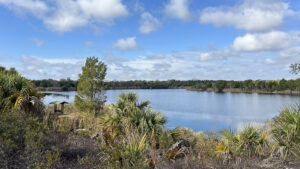
Expanse of blue water beyond trees

Phils Lake Trail

Part of the Great Florida Birding Trail, this 1.8 mile loop around a rewilded dolomite mine offers surprising panoramas across the surrounding coastal landscape.

Crystal River (29.012813, -82.656880)   1.8 miles   Felburn Park

Once the site of much heavy digging, first for an open pit dolomite mine and then the Cross Florida Barge Canal, Felburn Park is part of the Cross Florida Greenway.

Long mounds of fill characterize these disturbed landscapes, creating unusually hilly terrain that’s been undisturbed long enough to host native species.

Lake edged by trees Phil’s Lake is an open pit mine full of water


Home to the easternmost access point to the paved Withlacoochee Bay Trail, Felburn Park also has a lesser-known hiking trail.

From all appearances, the Phil’s Lake Trail appears to have been established a couple of decades ago. Trail markers are faded or missing.

However, it has two established overlook shelters and a high point panorama well worth the sometimes tricky to follow circuit.

Lake below ridge One of the views from the ridge


Resources

Resources for exploring the area
50 Hikes in Central Florida Central Florida Orlando Explorers Guide book cover Hikers Guide to the Sunshine State book cover Paddlers Guide Florida Hiking the Gulf Coast book cover
 
Disclosure: As authors and affiliates, we receive earnings when you buy through our links. This helps us provide public information on this website.

Overview

Location: Crystal River
Length: 1.8 mile loop
Trailhead: 29.01237, -82.65688
Address: 10201 N Suncoast Blvd, Crystal River
Fees: Free
Restroom: Flush toilets
Land manager: Florida State Parks
Phone: 352-758-1000

Open 8 AM to sunset. Leashed dogs welcome. Picnic pavilion adjoins restrooms.


Directions


From the intersection of SR 44 with US 19 in Crystal River, follow US 19 north for 6.4 miles to the traffic light for Dunnellon Rd. Continue another 2.9 miles on US 19 to the signposted turnoff on the right just before the bridge. It looks like you’re pulling into an RV park but the road slips past it into Felburn Park. Take a right at the park sign to follow the road to the parking area.

Hike

From the parking area, head towards the trail opening beyond the right side of the restrooms, marked only by a Great Florida Birding Trail sign.

The broad grassy corridor opens into a trail junction with the paved bike path beyond. Bear right.

Birding trail sign next to pathway Start of the hike


At the next junction, bear right where a lone cabbage palm dominates a triangular island of vegetation, starting a counterclockwise circuit around Phil’s Lake.

Low grasses and tufts of cordgrass blanket a hillside of old mine tailings, now repopulated by cedars and wax myrtle.

Grasses and cedars on hill Rewilded hillside


Along with cabbage palms, those species have made the strongest foothold on the long lines of rock piles blocking Phil’s Lake from view.

At the next junction, bear left. Although there are occasional posts and faded or torn trail markers, none of the junctions are clearly marked.

Walk a straightaway between cedar trees, meeting a broad path at a T junction with an old post. Bear left. Continue along a straightaway that climbs slowly.

Straightaway path Long straightaway before Y junction


At a quarter mile, bear left at a Y to head downhill towards the lake. Increasingly hemmed in, the grassy pathway narrows. Duck under palm fronds.

The grasses grow over a layer of limestone pebbles and rocks and boulders left behind when the mine was abandoned.

Lake beyond cedars Phil’s Lake


Framed by cedars, the first of a series of views of Phil’s Lake open up from this rocky terrace high above its waters.

Continue along the grassy terrace, coming to a spot where there’s an obvious beaten path to the right up and over a small sand ridge opposite of the lake.

Lightly beaten path with pines beyond Path over the sand ridge


From the ridge, a paralleling sand road is obvious below. Descend to it past a large gopher tortoise burrow and make a right to follow the road.

Narrowing through a line of oaks, the road curves to a view of marsh along the upper end of Phil’s Lake at a half mile.

Marsh along lake Marsh view


Keep with the sand road as it curves around the end of the lake and into a mesic flatwoods dominated by slash pines and sand live oaks.

A break in the forest reveals a fabulous panorama of the lake spreading off to the far horizon.

Panorama of lake Lake view


Ramble through the flatwoods, the hill on the left more mine tailings now covered in forest. One steep sand hill has gopher tortoise burrows in it.

Follow gentle curves in the two-track road between the pines and oaks, circling around a sizable live oak to pass a stand of young longleaf pines.

Young longleaf pines Young longleaf pines


At 0.8 mile, meet a T intersection in front of a sand mound with an enormous gopher tortoise burrow. Turn left.

Walk through a more mature forest, seemingly untouched by past mining. Saw palmetto covers the forest floor.

Mound with hole next to pathway Gopher tortoise burrow at T junction


Returning to the rewilded disturbed mining landscape, follow the grassy two-track between clusters of cabbage palms.

An alligator warning sign calls attention to a side path. Descend towards a sheltered bench at an observation point near lake level.

Bench along waterway Lakefront bench


As the mine was dug, it broke into the Floridan Aquifer. The same freshwater source of springs around Crystal River filled the mine.

Stepping to the right of the bench, you can peer into the depths of this basin of cool, clear water, seeing boulders below.

Boulders in mine pit water Boulders shimmer under the surface


Climb back to the junction and bear left. The steepness of the uphill is a surprise. Waterbars help prevent erosion of the footpath.

Follow an ever-narrowing ridge with fabulous views of the lake. A boundary fence is below to the right. Keep climbing.

Green fences along footpath on ridge Start of safety fences outlining path


By a mile, the ridge narrows enough that fencing defines the sides of the trail. Keep climbing. The height this ridge reaches is downright startling.

On the right it drops off into the yard of a neighboring homestead. On the left, the views across the lake to the far horizon beyond it are phenomenal.

Lake view over palm forest View across the landscape


The towers in the distance belong to the former Crystal River nuclear power plant, now a coal-fired power plant. It sits on the estuary edging the Gulf of Mexico.

Reach a sheltered observation bench at the high point of the ridge at 1.2 miles and savor the expansive view.

View of waterway below and palms beyond Looking northwest from the bench


Past the bench, start a steep descent, the ridge rocky and peppered with a thicket of cedars on this drop to sea level.

At the T intersection past a pile of boulders, make a left. Walk the grassy track under the spreading branches of live oaks.

Boulders near a trail junction post Descent off ridge


Emerge from the forest into an open area with pines and cedars. At the Y intersection, take the left fork to stay near the lake.

At the next junction, the right fork goes directly to the bike path. Take the left fork, walking amid cabbage palms and cedars.

Lake view with bench on ridge Distant bench on ridge


Views of Phil’s Lake open up once more. The observation bench at the high point is across the water.

Walk an alley defined by older cedar trees along the lakeshore, where a rocky protrusion invites one final view towards the lakefront bench at 1.4 miles.

Lake beyond rocky edge Final glimpse of Phil’s Lake


The grassy path descends through a cattail marsh, sweeping into a slight ascent to meet the paved bike path by 1.6 miles.

Visible uphill to the right is a post marking where the “official” route emerged at the bike path, cutting off the scenic quarter mile you just walked.

Paved path sweeping past oak Exiting to the bike path


Turn left to walk the paved path through the isthmus between freshwater Phil’s Lake and the brackish Cross Florida Barge Canal.

A developer wanted to break this open to create a marina, which would’ve caused serious saltwater intrusion into the aquifer.

Boat in a rocky cove Cove along the Cross Florida Barge Canal


Instead, the mine property was purchased with the help of the Felburn Foundation and became part of the Cross Florida Greenway.

Climb uphill away from the basin off the canal through two curves, the second one revealing a grassy opening on the left.

Leave the pavement and bear right past the post to seal your loop, exiting towards the trailhead restrooms to finish this 1.8 mile hike at the parking area.

Grassy expanse off paved trail Trail junction to seal the loop


Trail Map

Felburn Park Trail Map
Red: Phil’s Lake Trail. Blue: Paved path. Light blue: Withlacoochee Bay Trail.

Explore More!

Learn more about Felburn Park and the Withlacoochee Bay Trail

Cove with a boat floating in it between rocky walls and palm trees Felburn Park The eastern terminus of the Withlacoochee Bay Trail is home to a surprisingly hilly trail above a freshwater marsh along the saltwater Cross Florida Barge Canal.
Expanse of water with boat headed into distance Withlacoochee Bay Trail Paralleling a completed segment of the ill-conceived Cross Florida Barge Canal, this 5.1 mile paved bike path surprises with hills, overlooks, and a panorama stretching to the Gulf of Mexico.

Video

Hiking Phil’s Lake Trail


Slideshow

See our photos from Phil’s Lake Trail


Nearby Adventures

View of salt marshes from 30 foot tower Withlacoochee Gulf Preserve Immerse in the beauty of an expansive coastal estuary at Withlacoochee Gulf Preserve in Yankeetown to take in the panoramic views.
Edge of island along blue waters of lake Inglis Dam & Island Recreation Area The former deeply wooded north shore of the Withlacoochee River became an island in the 1960s with construction of the Cross Florida Barge Canal.
Shaded bridge over a wetland Crystal River Eco-Walk Traversing floodplain forests and mesic flatwoods, the ecological diversity of the Eco-Walk Trail is stunning, though at times it may require wet shoes to complete the loop.
Lush hammock Churchhouse Hammock Trail Explore a showy coastal hammock within Crystal River Preserve State Park from an easily-accessed pair of loops just north of downtown Crystal River.

Trail Map (PDF) Official Website

  • Author
  • Recent Posts
Sandra Friend
Sandra Friend
Author of 45 books, Sandra Friend established FloridaHikes.com in 2006 to expand on the field research she'd completed for her first six hiking guides. She has been honored with lifetime achievement awards from the Florida Trail Association and the Florida Outdoor Writers Association.
Sandra Friend
Latest posts by Sandra Friend (see all)
  • Michael Crotty Bicentennial Park - November 3, 2026
  • A.J. Henry Park - November 1, 2026
  • Okeeheelee Nature Center Trails - October 22, 2026
Category: Central Florida, Day Hikes, Hikes, Land Trusts, Loop Hikes, TrailsTag: Birding, Cross Florida Greenway, Crystal River, Florida State Parks, Hilly Trails, Inglis, Scenic Hikes

Sidebar

FarOut Guides

Our comprehensive trail logistics presented on offline maps:

Florida National Scenic Trail (1,500 miles)
Florida Keys Overseas Heritage Trail (108 miles)
Eastern Continental Trail in Florida (92 miles)


We earn a small commission on sales through these links. Thanks for your support!


Our Florida Guidebooks

We’ve written Florida guidebooks for over 25 years. These include Central Florida destinations.

Book cover with woman hiking through palms with baby carrier
Book cover of Florida Trail Hikes
The Florida Trail Guide fifth edition
50 Hikes in Central Florida 3rd edition

Explore More

Newest Articles for Central Florida

Two-track through pine savanna Hal Scott Yellow Trail
Footpath through coastal hammock Michael Crotty Bicentennial Park
Young longleaf pines at Hal Scott Hal Scott Preserve
FT sign under blue blaze next to trail corridor Land Bridge Loop

  • Facebook
  • Flickr
  • Instagram
  • Pinterest
  • Substack
  • Vimeo

FIND A TRAIL OR PARK

METROS: Bradenton. Clearwater. Crestview. Daytona Beach. Destin. Fort Lauderdale. Fort Myers. Fort Walton Beach. Gainesville. Jacksonville. Kissimmee. Lakeland. Melbourne. Miami. Naples. Ocala. Orlando. Panama City Beach. Pensacola. Port St. Lucie. Punta Gorda. St. Petersburg. Sanford. Sarasota. Sebring. Stuart. Tallahassee. Tampa. Vero Beach. West Palm Beach.

MULTI-REGION: Atlantic Coastal Ridge. Atlantic Coast. Bartram Trail. Big Bend. East Coast Greenway. Everglades National Park. Florida National Scenic Trail. Gulf Coast. Lake Wales Ridge. WATERWAYS: Indian River Lagoon. Intracoastal Waterway. Kissimmee River. St. Johns River. Withlacoochee River.

NORTHWEST FLORIDA: Altha. Apalachicola. Apalachicola National Forest. Big Bend Scenic Byway. Blackwater River State Forest. Blountstown. Bonifay. Bristol. Bruce. Cantonment. Cape San Blas. Carrabelle. Chattahoochee. Chipley. Crawfordville. DeFuniak Springs. Eastpoint. Ebro. Eglin Air Force Base. Freeport. Fountain. Gulf Breeze. Gulf Islands National Seashore. Holt. Madison. Marianna. Milton. Monticello. Mossy Head. Munson. Navarre. Navarre Beach. Newport. Niceville. Panacea. Panama City . Perdido Key. Ponce De Leon. Port St. Joe. Quincy. Santa Rosa Beach. Sopchoppy. South Walton. St. George Island. St. Marks. St. Marks NWR. Sumatra. Vernon. Wakulla. Wewahitchka. Woodville. WATERWAYS: Apalachicola River. Blackwater Bay. Blackwater River. Chipola River. Choctawhatchee Bay. Choctawhatchee River. Coastal Dune Lakes. Ochlockonee Bay. Perdido River. St. Marks River. Wacissa River. Wakulla River. Yellow River.

NORTH FLORIDA: Alachua. Amelia Island. Archer. Baldwin. Branford. Bronson. Bunnell. Callahan. Cedar Key. Chiefland. Crescent City. Cross City. Cross Creek. Dowling Park. Ellaville. Fanning Springs. Fernandina Beach. Flagler Beach. Fort White. Glen St. Mary. Green Cove Springs. Hawthorne. High Springs. Inglis. Jacksonville Beaches. Jacksonville Northshore. Jasper. Jennings. Keystone Heights. Lake Butler. Lake City. Live Oak.Macclenny. Mandarin. Mayo. Mayport. Micanopy. Middleburg. Old Town. Olustee. Orange Park. Osceola National Forest. Palatka. Palatka-Lake Butler Trail. Palm Coast. Palm Valley. Perry. Ponte Vedra. Rodman. Salt Springs. St. Augustine. Starke. Steinhatchee. Suwannee. Suwannee River Wilderness Trail. Suwannee Springs. Talbot Islands. Timucuan Preserve. Trenton. Waldo. Welaka. White Springs. Williston. Worthington Springs. Yankeetown. WATERWAYS: Santa Fe River. St. Marys River. Suwannee River. Tolomato River. Upper Withlacoochee River.

CENTRAL FLORIDA: Altamonte Springs. Apollo Beach. Apopka. Astatula. Astor. Auburndale. Bartow. Babson Park. Bayport. Belleview. Bithlo. Brandon. Brooksville. Bushnell. Canaveral National Seashore. Cassadaga. Christmas. Chuluota. Citrus Springs. Clearwater Beach. Clermont. Coast to Coast Trail. Cocoa. Cocoa Beach. Cross Florida Greenway. Crystal River. Dade City. De Leon Springs. DeBary. Deland. Deltona. Dunedin. Dunnellon. Edgewater. Enterprise. Eustis. Ferndale. Fort Meade. Frostproof. Geneva. Gibsonton. Haines City. Hernando. Hernando Beach. Holopaw. Homosassa. Inverness. Kenansville. Kissimmee. Lake Mary. Lake Wales. Largo. Leesburg. Lithia. Longwood. Lutz. Maitland. Malabar. McIntosh. Melbourne Beach. Merritt Island. Merritt Island NWR. Mims. Mount Dora. Narcoossee/Lake Nona. New Port Richey. New Smyrna Beach. Nobleton. Oak Hill. Oakland. Ocala National Forest. Ocklawaha. Ocoee. Oldsmar. Orange City. Ormond Beach. Osteen. Oviedo. Paisley. Palm Bay. Plant City. Poinciana. Polk City. Ponce Inlet. Port Orange. Ridge Manor. Riverview. Ruskin. Safety Harbor. Silver Springs. Sorrento. Spring Hill. St. Cloud. Tarpon Springs. Thonotosassa. Titusville . Umatilla. Viera. Walt Disney World. Weeki Wachee. Weirsdale. Wimauma. Windermere. Winter Garden. Winter Haven. Winter Park. Winter Springs. Withlacoochee State Forest. Withlacoochee State Trail. Yeehaw Junction. Zephyrhills. WATERWAYS: Alafia River. Halifax River. Hillsborough River. Lake Apopka. Little Manatee River. Ochlawaha River. Rainbow River. Tampa Bay. Wekiva River. Wekiva River Basin.

SOUTHWEST FLORIDA: Alva. Boca Grande. Cape Coral. Charlotte Harbor. Ding Darling NWR. Ellenton. Englewood. Estero. Immokalee. Marco Island. North Port. Osprey. Palma Sola. Palmetto. Pine Island. Port Charlotte. Sanibel Island. Venice. WATERWAYS: Caloosahatchee River. Manatee River. Myakka River. Pine Island Sound.

SOUTH FLORIDA: Arcadia. Basinger. Big Cypress National Preserve. Big Cypress Seminole Reservation. Big Cypress Swamp. Bowling Green. Clewiston. Everglades City. Indiantown. LaBelle. Lake Okeechobee Scenic Trail. Lake Placid. Lakeport. Moore Haven. Okeechobee. Ortona. Pahokee. Palmdale. Port Mayaca. South Bay. Wauchula. Zolfo Springs. WATERWAYS: Fisheating Creek. Lake Okeechobee. Peace River.

SOUTHEAST FLORIDA: Biscayne Bay. Biscayne National Park. Boca Raton. Boynton Beach. Coconut Creek. Coral Gables. Coral Springs. Davie. Delray Beach. Fellsmere. Flamingo. Fort Pierce. Hobe Sound. Hollywood. Homestead. Indrio. Jensen Beach. Juno Beach. Jupiter. Jupiter Farms. Key Biscayne. North Hutchison Island. Ocean to Lake Greenway. Palm Beach. Palm Beach Gardens. Pompano Beach. Redland. Sebastian. South Hutchinson Island. WATERWAYS: Florida Bay. St. Lucie River.

FLORIDA KEYS: Big Pine Key. Islamorada. Key Largo. Key West. Marathon. Overseas Heritage Trail.


©2006-2026, Sandra Friend & John Keatley | Disclosure | Site Index | Work with Us | Advertise with Us | Terms of Service and Privacy Policy

Florida Hikes PO Box 93 Mims FL 32754 | Contact
