
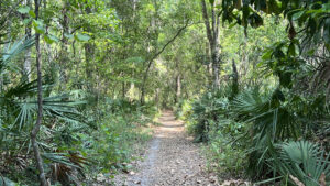
Encompassing uplands with outstanding examples of massive longleaf pines and southern magnolias, Mandarin Park was renamed for a hometown mayor in 2023.
It’s been a popular destination since 1990 for both its frontage on Julington Creek and a nature trail system showcasing the big trees.
 Park launch along Julington Creek
As the decades have passed, not so much care has been paid to the trails. They remain as immersive as always, just trickier to follow.
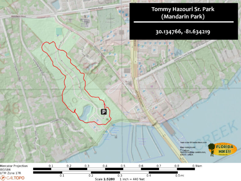
While the original signage has vanished, the major trails within the park were known as the Lake Loop and the Mandarin Loop. Our mile loop roughly follows the perimeter of both.
 Inside the lush hardwood hammock
Resources





Disclosure: As authors and affiliates, we receive earnings when you buy through our links. This helps us provide public information on this website.
Overview
Location: Mandarin
Length: 1 mile
Trailhead: 30.134766, -81.634219
Address: 14780 Mandarin Rd, Jacksonville
Fees: Free
Restroom: At the trailhead
Land Manager: City of Jacksonville
Phone: 904-255-7919
Open daylight hours, leashed dogs welcome. This is an urban park; be aware of your surroundings. The restrooms were in pretty sorry shape on our visit.
Directions
South of the Interstate 295 beltway, exit onto Old St. Augustine Rd from Interstate 95 and drive west for 3.7 miles. Make a left on Loretto Rd and continue 2 miles. Turn left on San Jose Blvd (SR 13) and drive 1.4 miles south, making a right just after the Wendy’s. Make a left on Mandarin Rd and turn right into the park entrance. Follow the park road to the picnic area parking adjoining the playground and restrooms.
Hike
Start your hike at the interpretive shelter adjoining the restrooms. Under its roof are panels describing the history of Mandarin, which acquired its first post office in 1830.
The postmaster was Walter Jones, and his property is now Walter Jones Historical Park at the north end of this old and deeply wooded community.
 Interpretive shelter
Panels also describe the plants and wildlife found in Mandarin Park. Step down the stairs to the sidewalk sweeping around a curve into the decidious forest.
The lush understory is dense with bluestem palm, the canopy of oaks and hickory aglow when brushed by sunlight.
 Start of the accessible walkway
A tenth of a mile from the trailhead, a post denotes the start of the footpath network around the park. It was freshened up as a 2016 Eagle Scout project.
Brush by palm fronds along a narrow corridor. An abandoned bridge into a bayhead is a remnant of the original trail system.
 Turnoff onto the footpath
Gaining a little elevation, rise through dappled shade. Among the towering trees around you is a sizable loblolly bay.
At a T intersection, bear right and note the massive oak dominating the canopy. Past an old wooden bench, a straightaway leads towards the park entrance road.
 Massive oak tree
Curve past the posts to avoid crossing it at this point. Streamers of Spanish moss dangle over in this tunnel of trees. Sunshine illuminates the many magnolia leaves throughout the forest.
The path nudges to the property boundary. A slight visual intrusion of the neighborhood beyond is worth it to to see the incredible size of the trees in this corner of the park.
 Red blazes mark the start of the route
The footpath empties onto the park entrance road a third of the way through the loop. Cross it, aiming for the narrow passageway into the woods on the opposite side.
Meet a four-way junction at 0.3 mile. The right turn goes to the tennis courts near the park entrance, and straight ahead leads towards a neighborhood. Turn left.
 Park road crossing
Reach a T intersection and turn right. This leafy path meets another intersection. Make a left. This starts you on the return loop within a second-growth forested corridor.
Beneath tall laurel oaks, mounds of grapevine spill to the footpath. An old bench is almost enveloped by them. At a T junction, bear right, walking beneath the oaks.
 Bench amid grapevines
The trail narrows through a thicket of younger trees. Broadening around a half mile, it immerses in a mature hardwood hammock.
Reaching a trail junction, you can see the park road through the gap on the left. Turn right for a deeper immersion in this healthy forest.
 Long straightaway
Past the next bench, start down a long, straight corridor. A pine forest with towering loblolly pines and loblolly bay follows.
A fern-dotted woodland cove just off the main path is framed by pines of incredible height.
 Woodland cove
Continue down a straight corridor edged by bluestem palm to emerge on the shoreline of a retention pond. Curving around it to the right at 0.8 mile, reach a T intersection.
Bear left to cross the parking area near the boat ramp. On its far side is a picnic pavilion under the tree canopy.
 Retention pond
A walkway past the pavilion leads to the pier extending over Julington Creek adjacent to the boat ramp. Walk out along the pier for outstanding views.
Across this broad tributary of the St. Johns River is a large marina, and the expanse of open river is visible to the west. A lily-dotted cove has a launch for paddlers
 Waterfront deck and pier
Leaving the pier, make a right and walk past the access point for the launch, where paddleboards are set up in a self-serve rental kiosk.
Join the sidewalk headed towards the playground to complete your circuit of the park, returning to the parking area by the interpretive pavilion after a mile.
 Self-service paddleboard kiosk
Trail Map
Explore More!
Video
Hiking Tommy Hazouri Sr. (Mandarin) Park
Slideshow
See our photos from this hike
Nearby Adventures
 Julington-Durbin Preserve Named for a pair of blackwater creeks that merge before entering the nearby St. Johns River, Julington-Durbin Preserve is a highly popular destination for exploring nature.
 Walter Jones Historical Park Centered on a farmstead set under a canopy of old-growth riverfront forest at historic Mandarin Point south of Jacksonville, Walter Jones Historical Park is a step into the past.
 Nocatee Preserve A linear buffer between a massive planned community and the Tolomato River in Palm Valley, Nocatee Preserve protects 2,400 acres of riverfront habitats north of St. Augustine.
 Tillie K Fowler Island Trail On a hike of nearly 2 miles, the Island Trail at Tillie K. Fowler Regional Park shows off upland and floodplain forest habitats along the Ortega River in Jacksonville.

- Michael Crotty Bicentennial Park - November 3, 2026
- A.J. Henry Park - November 1, 2026
- Okeeheelee Nature Center Trails - October 22, 2026