
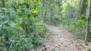
Partly in deep shade in a mature hardwood hammock and partly along the river and tidal marsh, the trail system connects to the paved paths of Blue Cypress Park.
A mile loop under old-growth trees connects the Nature Trail with the boardwalk, passing a picnic area beneath the pines.
 In the hammock
A showy boardwalk with accessible approaches at both ends spans between the parks along the riverfront, with a couple of stairs to the water for anglers.
Easy access to a boat ramp and fishing pier is at the riverside end of the large parking area, with picnic tables by the waterfront.
 Waterfront at boat ramp
Resources





Disclosure: As authors and affiliates, we receive earnings when you buy through our links. This helps us provide public information on this website.
Overview
Location: Arlington
Length: 1.8 miles
Trailhead: 30.377258, -81.618348
Address: 4322 Richard Denby Gatlin Rd, Jacksonville
Fees: Free
Restroom: At the trailhead
Land manager: City of Jacksonville
Phone: 904-255-7919
Open 7 AM to 9 PM. Leashed dogs welcome. Alternative access to the trails is available through Blue Cypress Park.
Directions
From Interstate 275 south of the Dames Point Bridge over the St. Johns River, exit on Merrill Rd. Drive west 3 miles to University Blvd. Turn right. Drive 2 miles north, past the entrance to Blue Cypress Park, to Richard Denby Gatlin Rd. Turn left. The park entrance is at the end of the road. Use the first parking area on the left; the far parking area stays busy with boater traffic.
Hike
From the trailhead, walk into the woods on the asphalt footpath. Reach a T intersection with a directional sign. Make a left to start the nature trail.
A narrow natural footpath, it quickly enters a mature hardwood hammock with towering trees.
 T intersection
Massive southern magnolia and live oaks dominate this lush woodland. Clumps of saw palmetto add texture to an understory busy with young trees.
A tenth of a mile in, a bench is almost swallowed up by the forest. Strewn with oak and magnolia leaves, the footpath crunches underfoot.
 Among the magnolias
Coming within sight of the park entrance road, the trail curves to parallel it. Grapevines and palmetto line the edges of the path.
A large opening in the forest reveals massive trees behind it. Keep right at a fork; the left branch empties onto the park road.
 The hardwood forest
Circling behind the backyard of the park caretaker’s home, the trail folds back towards the river basin at a quarter mile.
Grapevines dangle from the canopy; netted chain fern clusters in a damp spot. Walk beneath more towering trees, relaxed clumps of bluestem palm below.
 Approaching the caretaker’s yard
The understory of young trees is thin enough to reveal light off a salt marsh on the forest’s edge.
A short ways past the next bench, Southern magnolia dominates one corner of the forest.
 Bench before the magnolias
Making a sharp curve left, walk among drifts of magnolia leaves across the footpath in this lush green landscape.
As the magnolias thin out, some of their counterparts, loblolly bay, intermingle with the oaks.
 More magnolias
At a half mile, drawing ever closer to the salt marsh, the tang in the air is unmistakable.
Loblolly pines rise like column from mounds of soft needles they’ve dropped at their bases.
Well-cushioned underfoot, the footpath leads through a corridor defined by shrubs and saplings, clusters of swamp bay pressing close.
 Base of an enormous pine
Spills of grapevine form a tight passageway before the habitat relaxes into the hardwood hammock familiar from the start of this loop.
At 0.6 mile, an unmarked but obvious junction provides a shortcut directly back to the trailhead.
Pass it by and stay on the main trail, crunching across fallen magnolia leaves.
 Narrowing corridor
The brightness ahead signals a habitat shift to mesic flatwoods. Sweetgum sprouts under the oaks as the trail corridor narrows.
Emerge on a low bluff above the salt marsh. Widening, the footpath curves past a bench under the pines and oaks
 Bench in a clearing
Dark, damp earth appears underfoot along a line of palms. Weave between palms under towering loblolly and slash pines.
A short side trail leads to a bench along the salt marsh. Continue down a corridor of tall pines to a clearing canopied by oaks.
 Salt marsh bench
It is the picnic area promised on the trailhead sign, with a covered pavilion and scattered park benches under the pines and oaks.
Stay left along the picnic area’s edge to find a beaten path into the salt marsh at 0.8 mile. Take the ramp to the riverfront boardwalk. Turn left.
 Picnic area
Hovering between the salt marsh and the St. Johns River, the boardwalk provides panoramas in all directions.
Many are industrial, like the piles of sand and earth across the river with the skyscrapers of downtown Jacksonville behind them.
 Walking towards Blue Cypress Park
This protected shoreline has a scrim of pine forest between the marsh and river, making for a pleasant, breezy walk.
Hermit crabs scuttle along the tiny sand beaches on the riverfront, and egrets pick through the shallows.
 Looking towards downtown Jacksonville
Making a sharp left, the boardwalk faces a pier extending out into the river. Cross over a salt creek flowing in mazy curves out of the salt marsh.
Drawing close to the end of the boardwalk, it becomes obvious that it’s no longer possible to walk to that observation deck.
Hurricane-driven floodwaters detached the pier from this boardwalk.
 Detached pier
At a sharp left, the boardwalk descends a ramp into neighboring Blue Cypress Park, with a trailhead in sight.
This park has its own paved trail leading to the front entrance and a loop to the marsh. This is your turnaround point for Arlington Park.
 Accessible trailhead inside Blue Cypress Park
Savor the return walk along the river, reaching to the ramp you used to access the boardwalk at 1.2 miles.
Pass the ramp and continue along the boardwalk. A set of stairs into the river provides access for anglers.
 River access
A second set across from a ramp ends on a tiny strip of beach. Continue past this intersection.
The boardwalk ascends and fronts a law enforcement complex and its boathouse.
After another waterfront stretch, the walkway jogs to its conclusion at the park’s boat ramps at 1.5 miles.
 North end of the boardwalk
Cross the ramps to see the interpretive panels near the sheltered picnic table.
They outline details on the human history of this riverfront.
Return along the boardwalk to the staircase to the beach. Take the ramp on the left to the asphalt path.
It closes the loop with the nature trail. Turn left to return to the trailhead, completing a 1.8 mile walk.
 Ramp leading to trailhead
Trail Map

Explore More!
Video
A walk through Arlington Lions Club Park
Slideshow
See our photos from Arlington Lions Club Park
Nearby Adventures
 Reddie Point Preserve Sand beaches and salt marshes fringe a wild peninsula along the St. Johns River where trails meander more than a mile to reach a mature hardwood hammock.
 Jacksonville Arboretum & Gardens For a surprising diversity of habitats and hilly terrain, the Jacksonville Arboretum and Gardens is a hidden treasure for hikers and a bonanza for botanical delights
 Fort Caroline At the site of the original French settlement in Florida, explore the rich natural and cultural history of the region at the Timucuan Preserve visitor center, Fort Caroline, and its interpretive nature trail.
 Theodore Roosevelt Area Hike 3.1 miles looping around an ancient midden fronting the St. Johns River on this scenic hike honoring the conservation legacy of Willie Brown, who preserved his coastal forest for us to enjoy.

- Michael Crotty Bicentennial Park - November 3, 2026
- A.J. Henry Park - November 1, 2026
- Okeeheelee Nature Center Trails - October 22, 2026