
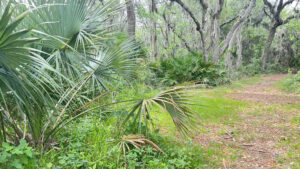
Along the north tip of the peninsula in the Arlington section of Jacksonville, Reddie Point has a commanding shoreline along the St. Johns River beloved of anglers for its long fishing pier.
Residents enjoy the palm-lined sandy waterfront, where paddlers can launch to explore the natural waterfront of the preserve. Picnic tables cluster near the main parking area.
 The picnic area and pier are accessible
A network of marked pathways span from the front entrance to the tip of the peninsula, where a mature hardwood forest commands the high ground.
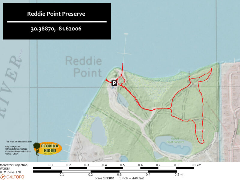
On this 1.5 mile double loop route, leave the busier portion of the park behind to discover views along the marshes and a large pond in the forest.
 Marshes fringe the waterfront near the point
Resources





Disclosure: As authors and affiliates, we receive earnings when you buy through our links. This helps us provide public information on this website.
Overview
Location: Arlington
Length: 1.5 miles
Trailhead: 30.388704, -81.620058
Address: 4499 Yachtman Way, Jacksonville
Fees: Free
Restroom: Portable toilets at trailhead
Land manager: City of Jacksonville
Phone: 904-255-7919
Open sunrise to sundown. Leashed pets welcome; please pick up after your pet.
Amenities include picnic pavilions and a 700 ft fishing pier with daytime dockage.
Directions
From Interstate 295 east on the approach to or from the Dames Point Bridge, use exit 46 for Merrill Rd. Follow it west 2.8 miles towards Jacksonville University. Take the first exit on the traffic circle onto University Blvd. Continue north 2.5 miles, passing Blue Cypress Park en route. Turn right on Yachtmans Way. Continue through the neighborhood and bear left in a quarter mile into the park. Follow the park road to where it ends at the parking area closest to the waterfront.
Hike
From the parking area, follow the broad sidewalk over the crosswalk to a park sign and kiosk with trail map. Straight ahead are picnic pavilions and the fishing pier.
Turn right, walking along the edge of the park road to an entry point behind a fence. This broad pathway is the Main Trail, marked with posts with red rings.
 Start of the Main Trail
Pass a side trail to the right. Wildflowers and vines spill along the edges as the clearing the path follows is hemmed in by forest.
Cedars crowd the next junction, a T intersection at a quarter mile. Turn left onto the grassy path.
 Following the Main Trail
The next junction comes up quickly. Bear left to follow the outer edge of the loop, lined by cabbage palms and cedars.
A saline breeze permeates the air as the trail works its way around a salt marsh hidden behind the trees.
 Palms outline the marsh edge
Despite the inflow of the Trout River, this part of the St. Johns River is close enough to the Atlantic Ocean to be tidally influenced.
Loblolly pines rise above a line of oaks defining the high ground. Reaching a signposted junction of the Main and Marsh Trails at 0.4 mile, turn left. The path splits again.
 Junction of Main and Marsh Trails
Follow a worn footpath straight ahead to the marsh defining the St. Johns River shoreline.
Across the water, the profile of the forest on Goat Island is a welcome break from the usual industrial complexes along the river.
 Goat Island and the far shoreline of the St. Johns River
Downriver, the massive container-lifting cranes at the port at Blount Island rise above the horizon.
Backtrack to the path entering the woods to continue along the Marsh Trail.
Unlike the hike thus far, this is an immersion in a coastal hammock dominated by oaks and hickories. Streamers of Spanish moss dangle from above.
 Beneath wind-stripped sand live oaks
The upper limbs of the taller trees are stripped, but the lower canopy casts shade.
Walk past clumps of saw palmetto to the northernmost point of the preserve at 0.6 mile.
An opening in the trees provides a foreground of salt marsh against a panorama of the St. Johns River.
 Peeking through the opening
Curving away from the river into the woods, follow a straightaway to the upper junction of the Marsh and Main Trails at 0.7 mile.
Continuing straight ahead hurries you back to the trailhead, so make a left.
A leaf-strewn walkway leads under the oak canopy, turning to sand as it approaches pavement.
 Upper junction
Emerge onto a road that was intended as a continuation of the adjoining neighborhood.
The county’s acquisition of this land stopped further development, but not before this road was built. A red-ringed marker denotes it as part of the Main Trail.
 Trail junction at old road
Cross the road to a straightaway under the trees. Meet the next marker where a side trail merges in.
Continue forward, rounding a bend within sight of a pond.
Walk through this beautiful bluff hammock under tall trees as the trail arcs back towards the center of the preserve.
 Leafy pathway
Reach the old road again at a mile. Make a left at the post and follow the leaf-obscured pavement under the live oaks.
Within a tenth of a mile, come to a large grassy area where trails intersect, completing your loop.
 Broad grassy junction
Turn left to exit along the broad wildflower-edged pathway. At the fence where you can see the trailhead, follow the curve of the path instead under a tunnel of trees.
Emerge behind a picnic pavilion and walk up to the pier. Walk out at least half its length for great views up and down the St. Johns River.
 Long fishing pier
Returning to the parking area via the sidewalk, turn your attention to the slender sidewalk leading towards a kiosk with a map of the river.
A sandy path continues to the launch on the St. Johns River. Glimpse the palm-lined river through the trees before emerging onto its rocky shoreline.
 Kiosk at launch
If the tide is out, wander along it to contrast this rugged natural shore with the industrial side of the river.
Retrace your steps to the parking area to complete a 1.5 mile hike.
 Palm-lined shore
Trail Map
Explore More!
Video
A walk through Reddie Point Preserve
Slideshow
See our photos from Reddie Point Preserve
Nearby Adventures
 Arlington Lions Club Park A breezy walk along the St. Johns River awaits at this park near the north end of Arlington, its half mile riverside boardwalk connecting to showy upland trails and to Blue Cypress Park.
 Jacksonville Arboretum & Gardens For a surprising diversity of habitats and hilly terrain, the Jacksonville Arboretum and Gardens is a hidden treasure for hikers and a bonanza for botanical delights
 Robert W. Loftin Nature Trails In a densely wooded corner of the University of North Florida in Jacksonville, the Robert W. Loftin Nature Trails are a prime place for trail runners and hikers to play.
 Bogey Creek Preserve A well-interpreted and easy loop hike honors the legacy of a Jacksonville author who left her waterfront homestead for future generations to enjoy.

- Michael Crotty Bicentennial Park - November 3, 2026
- A.J. Henry Park - November 1, 2026
- Okeeheelee Nature Center Trails - October 22, 2026