
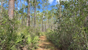
A gentle family-friendly loop in Cary State Forest west of Jacksonville, the 1.6 mile Cary Nature Trail focuses on the flora of a wet pine flatwoods and a cypress strand.
While the 13,000-acre forest has dozens of miles of multi-use trails, the Cary Nature Trail is hiking only, part of the Florida State Forests Trailwalker program.
 A hallway-like corridor through the pine flatwoods understory
One of its primary highlights is a boardwalk called Adams Wilderness Trail, established in 1974 and about to undergo another renovation.
But even along the footpath portions, sometimes the most interesting surprises are at your feet in the soggy boggy spots: toads, frogs, and carnivorous plants.
 Hooded pitcher plant blooming in a bog
Resources





Disclosure: As authors and affiliates, we receive earnings when you buy through our links. This helps us provide public information on this website.
Overview
Location: Bryceville
Length: 1.6 mile loop
Trailhead: 30.400070, -81.926946
Address: 7465 Pavilion Rd, Bryceville
Fees: $2 per person
Restroom: Near the pavilion
Land manager: Florida State Forests
Phone: 904-266-8398 weekdays, 904-266-8396 weekends
Open dawn to dusk. Leashed dogs welcome.
Picnic tables and restrooms are at the pavilion. A small tent campground nearby is perfect for families with young children. Sites must be reserved in advance.
Directions
From Interstate 10 exit 343, Baldwin/Starke, head north on US 301 for 9 miles. After you pass the Bryceville fire station and a “Welcome to Cary State Forest” sign on the right. Keep alert for the first turnoff, Pavilion Rd. Turn right. Park at the grassy picnic area with a kiosk on the right at the corner with Fire Tower Rd.
Hike
At the trailhead kiosk, pay your state forest usage fee and pick up a trail map. Cross Pavilion Rd to the signpost for the Nature Trail and Teaching Pavilion.
A short bridge spans the roadside ditch to a grassy path under the pines. A large fenced parking corral for horse trailers is visible through the underbrush.
 Footpath towards the pavilion
Head towards the green-roofed pavilion, meeting the loop trail junction at a sign and bench at a tenth of a mile. Take the left fork for a clockwise walk.
Marked with lime green blazes, the grassy route through the pine flatwoods winds through dense staggerbush and gallberry.
 Enter to the left of the big trailhead sign and bench
Pines rise in tall columns overhead. The path narrows as walls of shrubs create a hallway effect.
Past an interpretive sign for bats, a low-lying spot in the footpath may be damp. Shrubs overhang the trail.
 Bat sign
Meet a T intersection at a blazed post. Turn right, passing a bluebird box and interpretive sign.
Bay trees infiltrate the thicket of understory, indicating growing dampness under the pines.
 Approaching the bluebird box
At a half mile, reach a second T intersection. The observation tower once stood in the clearing on the left but has not been rebuilt. Turn right.
Saw palmetto becomes a little more prevalent. Maze-like, the path meanders between walls of shrubs as the density of tall, skinny pines increases.
 The large clearing is where the tower used to be
A broad clearing at a curve reveals a bench and an interpretive sign on the pine flatwoods.
Duck under low-hanging branches as the maze effect continues. Ferns sprout in seasonally damp spots.
 Bench along a curve
Start down a straightaway with soggy, mossy spots, an interpretive sign near its end.
Small grassy clearings start to appear on the right at the edge of the ecotone between the pines and a bayhead beyond.
 Corridor along the ecotone
Three quarters of a mile into the hike, take the broad path on the right. It ends at a slightly elevated observation deck.
Overlook a bog with scattered clusters of hooded pitcher plants. Scan it carefully, as they blend in well against their backdrop.
 Carnivorous plant bog
Returning to the main trail, continue north. More bay trees edge the trail. Emerge at a grassy forest road, where signage and a double blaze guides you into a right turn.
Shared with equestrians and cyclists as part of a larger trail system in Cary State Forest, Moccasin Slough Rd meets graded Hog Trap Rd at a signposted junction.
 Signposted junction
Turn right. Blackwater swamp edges both sides of the road before you reach the signposted turnoff to Adam’s Wilderness Trail.
It is adjoined by a bench at 1.1 miles. Aquamarine blazes guide you onto a boardwalk carpeted with pine needles.
 Start of the boardwalk
Built in 1974, the boardwalk is one of the oldest pieces of the trail system and is scheduled for replacement. After a long straightaway, it zigzags between skinny pond cypresses.
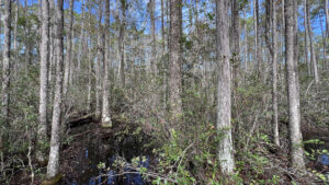
A lowlying drainage, the cypress strand feeds the nearby blackwater swamp. Dense vegetation marches right up to the water’s edge.
 A tangled, damp forest
Columns of cypress become so thick they blot out the surrounding pine flatwoods. Cross larger pools of water reflecting the sky.
Cypress knees protrude from hummocks in this dark swamp. Curving over a puzzle of land and water, note scattered plant identification signs and a wood duck nesting box.
 Approaching the nesting box
When the pines begin to crowd closer, one spots a catface carved into its side for tapping turpentine long ago.
Leaving the swamp behind, the boardwalk hovers over the flatwoods, for a significant stretch.
 In the flatwoods
The boardwalk broadens to accommodate a bench and ends past a second Adam’s Wilderness Trail sign at 1.3 miles.
Step back onto a grassy footpath, broad and somewhat soggy. A bench sits in a small clearing. Spagnum moss releases water when you step on it.
 Clearing past the boardwalk
Bog-loving star-shaped marsh pinks displays pale pink blossoms. Orange wild bachelor’s button pokes up from the grassy footpath.
Past a particularly squishy spot, continue along a straightaway under the pines to reach a decision point in the trail at a bench.
 Decision point
Forest maps and the arrow at this corner show the nature trail turning left. However, that short walk took us up to Fire Tower Rd and the park maintenance area.
No blazing pointed to a second boardwalk beyond it. Asking a ranger, we learned that boardwalk was storm-damaged and inaccessible. It, too, is slated for a rebuild.
 The left turn at the bench led here
Unless it’s obvious the upper boardwalk has reopened (blazes should cross Fire Tower Rd, not turn right), skip that side trip and continue straight ahead at the bench.
The broad grassy trail ends at the start of the Nature Trail loop at the pavilion. Continue straight ahead to the trailhead, completing this hike after 1.6 miles.
 Back to the pavilion and its nearby restrooms
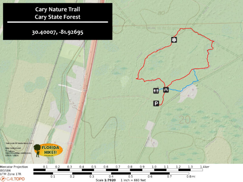
Trail Map
Explore More!
Learn more about Cary State Forest
 Cary State Forest Protecting more than 20 square miles of forest northwest of Jacksonville, Cary State Forest has over 20 miles of marked trails for hiking, biking, and equestrian use.
Slideshow
See our photos from the Cary Nature Trail
Nearby Adventures
 Camp Milton Historic Preserve On a walk through Camp Milton Historic Preserve, discover Civil War stories through a grove of historic trees that have tales to tell beneath their leafy shade.
 Jacksonville-Baldwin Rail Trail Following a historic railroad route that sparked the Battle of Olustee during the Civil War, the Jacksonville-Baldwin Rail Trail spans 14.6 miles from Jacksonville to Baldwin.
 Sal Taylor Creek Preserve Along a pine forested greenway, this preserve offers hikers numerous easy-to-hike trails, including a main trail that leads to a blackwater creek.
 Bethea State Forest With nearly 40,000 acres along the Florida-Georgia border, John M. Bethea State Forest provides an important corridor for wildlife migrating between the Okefenokee Swamp and Osceola National Forest.

- Michael Crotty Bicentennial Park - November 3, 2026
- A.J. Henry Park - November 1, 2026
- Okeeheelee Nature Center Trails - October 22, 2026