

Located across SR 85 from where the orange-blazed Florida Trail turns towards Crestview, the Cimarron Trail carves a path farther west through Eglin Air Force Base.
In the future, hopes are for the blue blazes of the Cimarron Trail to be painted orange once a way to cross the Yellow River and its swamps are settled upon.
 Gum swamp along the north shore of the Yellow River
Maintained by the Florida Trail Association, this spectacularly scenic route features multiple hand-cut water crossings and benches among its structures.
The trail is a linear 8.5 miles, but hiking it from SR 85 requires a 17 mile round-trip. Available by permit, primitive camping is at Duck Pond Recreation Area.
Parking near the middle at Duck Pond enables shorter round-trip day hikes, but the roads to reach the pond are dirt.
 The Cimmaron Trail starts across SR 85 from Pearl trailhead
Our Florida Trail Books & Guides


Disclosure: As authors and affiliates, we receive earnings when you buy these through our links. This helps us provide public information on this website.
Overview
Location: Crestview
Length: 17 mile round-trip
Trailhead: 30.687048, -86.571915
Address: SR 85, Crestview
Fees: $5 day use fee
Restrooms: None
Land manager: Eglin Air Force Base
Phone: 850-882-4164
All hikers must have a permit in advance of arriving at Eglin Air Force Base. Day use permits are $5, annual permits $20. Obtain a permit online.
Before your hike, call 850-882-4164 or check the Public Access Map online to ensure the base is open: FPCON DELTA status means the base is closed to public access.
Eglin is an active military installation with ongoing training maneuvers. Aircraft may fly very low over the tree canopy and you may hear bombing.
Stay in the trail corridor and use established campsites. If you notice any sort of ordinance – rocket, bomb, hand grenade – do not approach it. Note the location and call Eglin Security Forces at 850-882-2502 to report it.
Check hunt dates as a part of your trip planning, and always wear bright orange clothing during hunting seasons.
Directions
From Interstate 10 in Crestview, drive south on SR 85 for 3.1 miles, crossing the bridges over the Shoal River. Get in the left lane. You’ll see a large FNST sign next to the road. Turn left at the turnout for Col. Greg Malloy Rd but make a U-turn instead to get in the northbound lanes of SR 85. A quarter mile north, a parking area for the trailhead is located on the right side of the road.
Hike
Starting at Pearl trailhead, carefully cross State Road 85, a busy four lane thoroughfare with high-speed traffic.
Look for a clearing in the trees on the other side, revealing a dirt road leading into the woods.
 Pearl Trailhead
At 0.2 mile, Turkey Hen Creek presents an interesting water obstacle early in the hike.
Although the water is generally clear and shallow, the creek is wide. The crossing will likely result in wet feet.
On the opposite bank, pitcher plants and orchids cluster near a pair of blue blazes indicating the direction of the trail.
 Turkey Hen Creek
Passing an informational kiosk, follow a pathway of yellow-tinged sand as it meanders into sandhill habitat.
A mix of red oaks and pines rise above the forest floor covered in blueberry bushes, woody goldenrod, and bracken ferns.
 Sandhill scenery
The landscape changes over time in this fire dependent community, as blue blazes lead through a series of open and densely vegetated areas for two miles to Gopher Creek.
The trail crosses a shingle-covered bridge over clear, fast-moving waters before climbing a gentle slope to an upland forest carpeted with deer moss.
 Gopher Creek
A set of trailside benches provide a resting spot at the four-mile mark as the trail traces alongside Crain Pond.
Tall pitcher plants and sundews grow in clusters along a tranquil shoreline as frog chirps echo across the water.
 Pitcher plants
Nearly a mile past the halfway point, the trail crosses an access road leading to Duck Pond, a recreation area with designated camping.
Continue across the road as the trail descends sloping terrain into a shady hardwood canopy.
 Duck Pond sign
Sounds of bubbling water filter through the trees as the trail approaches Carr Branch, a cool, clear stream flowing out of Duck Pond.
Impressive structures constructed of halved trees cross wet sections of the path while blue blazes lead into a floodplain ecosystem.
 Carr Spring Branch
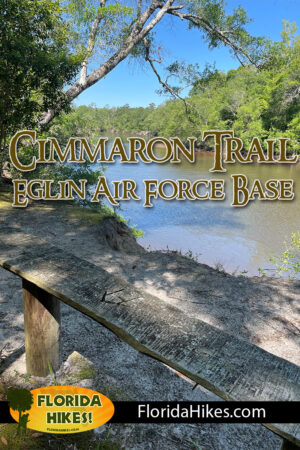
At 6.8 miles, the Yellow River comes into view as the trail rises to a bluff with a set of benches overlooking the water.
As the trail continues west, well-crafted boardwalks provide an elevated walkway over increasingly swampy soils.
 Bluff bench
Christmas Slough is the first major water crossing in the swamp, with a tree that was expertly taken down across the water before becoming a bridge fitted with a wire handrail.
The trail continues across One at a Time, High Water, and Cimarron bridges, each structure boasting a sign denoting the name.
 Christmas Slough bridge
At the deep slough crossing at Valentine Bridge, a huge cypress borders the trail, towering above the surrounding forest.
Cypress trees increase in number. Hundreds of knees protrude from the soft ground. Depending on the time of year, mosquitoes become more prevalent as well.
 Cypress at Valentine bridge
Shortly after crossing the Dead End Bridge, a sign and three-blaze pattern indicates the end of the Cimmaron Trail at 8.5 miles.
At some point in the future, a bridge may span the Yellow River here, where the path will continue through swamps on the north shore to reach Yellow River Ravines.
 Yellow River at the end of the trail
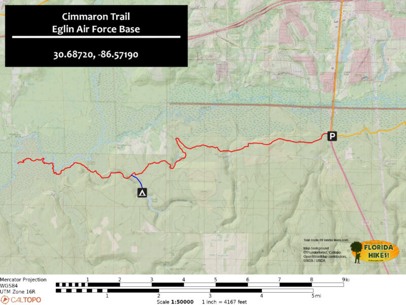
Trail Map
Explore More!
Learn more about the Florida Trail at Eglin Air Force Base.
 Florida Trail, Eglin One of the most compelling sections of the Florida Trail for backpackers, the 98.3 miles through Eglin offers rugged elevation changes and crystalline waterways.
Video
Nearby Adventures
More worth exploring while you’re in this area.
 Bone Creek Loop Trail Along a tributary of the Blackwater River, the Bone Creek Loop at Blackwater River State Forest is a well-maintained trail with a set of scenic boardwalks.
 Florida Trail, Yellow River Ravines 10.9 miles. An acrobatic adventure, the Florida Trail Yellow River Ravines section between Holt and Milton tosses tricky swamp traverses and creative creek crossings your way.
 Florida Trail, Eglin East 41.8 miles. Simultaneously rugged and scenic: that's the beauty of a backpacking trip across the Alaqua, Catface, and Titi sections of the Florida Trail in Eglin Air Force Base.
 Florida Trail, Titi 14.8 miles. Paralleling the floodplain of Titi Creek and its tributaries, this hike on the Florida Trail across Eglin will surprise you with its mature longleaf pine forests and its steep descents into creek basins.

- Calusa Heritage Trail - November 5, 2026
- Scherer Thaxton Preserve - October 21, 2026
- Little Awesome Preserve - October 19, 2026