• Skip to main content
  • Skip to header right navigation
  • Skip to after header navigation
  • Skip to site footer
Florida Hikes logo

Florida Hikes

Hike Bike Paddle Camp Florida with authors Sandra Friend and John Keatley as your guides

  • Trails
  • Maps
  • Guidebooks
  • Hike
    • Scenic Hikes
    • Loop Trails
    • Dog-friendly Hikes
    • Hikes for Kids
    • National Parks in Florida
    • Florida State Parks
  • Bike
    • Major Bike Trails
    • Paved Bike Trails
    • Off Road Biking
    • Biking Articles
  • Paddle
    • Canoe & Kayak Rentals
    • Paddling Destinations
    • Paddling Articles
  • Camp
    • Cabin Rentals
    • Car Camping
    • Primitive Camping
  • Florida Trail
    • Plan your Hike
    • Best Scenic Hikes
    • Best Backpacking
    • Section Hiking
    • Thru-Hiking
    • Trail Updates
  • Travel
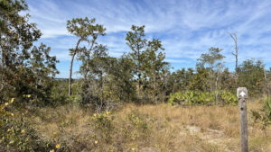
Arrow pointing towards distant ridge

Crooked Lake Sandhill

On surprisingly steep slopes, the 0.8 mile trail at Crooked Lake Sandhill scrambles a forested ridge above Crooked Lake.

Frostproof (27.814030, -81.547815)   0.8 miles  

Perched well above its namesake lake, Crooked Lake Sandhill offers a scaled-down version of the upland loops at the heart of nearby Tiger Creek Preserve.

Atop this folded landscape on the Lake Wales Ridge, elevations rise to 215 feet above sea level and drop dramatically.

Footpath amid straw-colored grasses Descent off the ridgetop


Scenic views surprise along the trail’s twists and turns, a delight to hike.

Cloaked in healthy sandhill with turkey oak and longleaf pine, this 25 acre preserve has old-growth trees up to two centuries old.

Tall pines and turkey oaks Among the sandhills


Resources

Resources for exploring the area
Florida Trail Hikes book cover The Florida Trail Guide book cover 50 Hikes in Central Florida Central Florida Orlando Explorers Guide book cover Hikers Guide to the Sunshine State book cover
 
Disclosure: As authors and affiliates, we receive earnings when you buy through our links. This helps us provide public information on this website.

Overview

Location: Frostproof
Length: 0.8 miles
Trailhead: 27.814030, -81.547815
Address: 801 Hollister Rd, Babson Park
Fees: Free
Restroom: At the trailhead
Land manager: Polk County Natural Lands
Phone: 863-534-6000

Open 6 AM to 6:30 PM standard time, 5:30 AM to 8 PM daylight savings time. No pets allowed.


Directions


From the junction of CR 630 with Scenic 17 in Frostproof, drive north on CR 17 for 3.7 miles. Turn left on Cody Villa Rd. After a half mile turn right on Wes Mann Rd. In another half mile turn left on Hollister Rd. The trailhead is on the left.

Hike

Walk through the pass-through to the trailhead kiosk to pick up a map and learn some of the background of this preserve and its sandhill habitat.

From this high vantage point, views are wide open across one arm of Crooked Lake far below on the other side of Hollister Rd.

Lake view from hilltop View of Crooked Lake from the kiosk


Follow the worn path through the grassy upland, young longleaf pines and mature turkey oaks swaying in an ever-present breeze. The descent begins immediately.

Clusters of sand spikemoss rise from bare sandy patches. Tall grasses sport showy stalks as they go to seed in fall.

Broad yellow-orange sand path down hill Rapid descent


Drop into a forest of sand live oaks and large clumps of mature saw palmetto. Dip into dappled shade, reaching a T junction at a tenth of a mile.

The first of many brown arrows points left. Make the turn to follow a flat, broad path that feels like an old road.

Oak hammock with footpath Closing in on the T junction


Scrub and sandhill intermingle, sand spikemoss and lichens adorning orange sands. On the edge of these grassy patches, turkey oaks thrive.

Reach a four-way intersection, or so it seems. To the left, a picnic table sits under the oaks in a small clearing.

Picnic table under oaks Picnic spot


Straight ahead, this road-like path simply vanishes, a man-made grassy slope topped with houses looming beyond the preserve boundary fence.

While no arrow indicates it, the trail turns right. Follow the narrow, winding footpath on a steady downhill into the sandhills.

Path downhill in sandhill habitat Descent into the sandhills


Watch for arrows, as they are crucial at turns where the lush grassy understory obscures the footpath. Slender pines rise in the distance.

At a quarter mile, start the loop. An arrow on a turkey oak points uphill to the right. Climb gently towards much taller turkey oaks above an island of saw palmetto.

Hilly climb in grass between turkey oaks Ascending the hill


Traversing this pretty hilltop, note the wildflowers hidden in the grass. The next arrow points past a panorama of the lake and ridge beyond it.

Swoop around a cluster of scrub oaks and through a switchback for a rapid descent. Slip into a tight tunnel of oaks, longleaf towering on higher ground.

Arrow pointing towards forest On the long descent


Scrub and sandhill coalesce once more, habitat shifting at twists and turns. Weave around Spanish bayonet and scrub palmetto as the path winds beneath younger oaks.

Curve past an arrow marker over a spill of grapevines across the grass. The path becomes a mere trace from marker to marker amid the grasses and shrubs.

Narrow trace of trail amid low trees Keep alert to the twists and turns


At the midpoint of the loop, your surroundings open up into an immersive sandhill. Trace its edge beneath the larger oaks past vigorous clusters of gopher apple.

It’s a favored food for the gopher tortoises that no doubt reside here.

Large amount of small green leafy plants in grass Prolific gopher apple


Enter a copse of tall oaks with scrub hickory and scrub oaks as a lower canopy, a diminutive forest.

Emerge into a corridor of sandhill where certain plants are flagged; this preserve has a high density of uncommon species.

Many short trees with pathway snaking through The immersive forest


Continue into stands of younger trees, ascending uphill. The footpath narrows briefly through a curve.

The climb between the turkey oaks becomes more pronounced on the sweep uphill. Amid patches of white sand, seal the loop at a half mile.

Worn sandy path in sandhill habitat Nearing the end of the lower loop


Continue straight ahead, uphill to the junction with the picnic table. Turn left to retrace your route to the next junction beneath the tall oaks.

Instead of turning right to exit, go straight towards the cabbage palm. The broad path curves to reveal an enormous tree beyond it.

Worn orange sand road in forest Retracing the old road from the picnic table


It’s a ficus, undoubtedly planted by the homesteaders who once lived here, and a grand example of one.

Step into its shade to examine the dense cluster of trunks making up its support system.

Showy tropical tree with prop roots Under the ficus canopy


A mowed path curves past it and starts uphill along the boundary fence. Views down the hill to Crooked Lake and the distant ridge persist all the way up to the top.

Follow a worn path from the end of the mowed area to the trailhead kiosk, completing this very immersive hike after 0.8 mile.

Mowed path adjoining paved road Mowed path to the trailhead


Trail Map
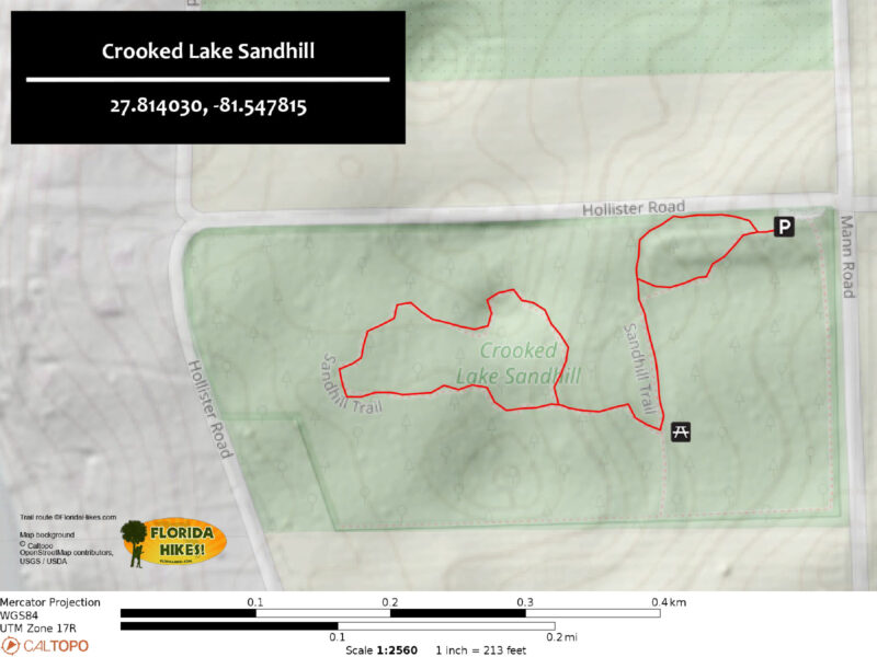
Crooked Lake Sandhill Trail Map


Explore More!

Learn more about the Lake Wales Ridge
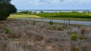
Lake Wales Ridge above Crooked Lake Lake Wales Ridge South of Lake Apopka, the Lake Wales Ridge is a significant landform down the middle of the Florida peninsula, with its highest hills and oldest biological communities.

Video

Hiking Crooked Lake Sandhill


Slideshow

See our photos from Crooked Lake Sandhill


Nearby Adventures

Expanse of lake with grass foreground and ridge on far shore Crooked Lake Prairie At Crooked Lake Prairie, the dunes of the Lake Wales Ridge meet showy prairie grasslands along the eastern shore of Crooked Lake.
Tiger Creek Preserve scrub ridge Tiger Creek Preserve Edward Bok's "Jungle," a deeply folded landscape between Tiger Creek and Patrick Creek south of Lake Wales, is protected by The Nature Conservancy as Tiger Creek Preserve.
Scrub habitat with footpath Ridge Audubon Center Atop the Lake Wales Ridge, the nature trails at the Ridge Audubon Center in Babson Park do a fabulous job of interpreting the unique flora and fauna of this island of biodiversity.
Scrubby habitat with a faint trail Hickory Lake Scrub Edging the eastern shore of Hickory Lake south of Frostproof, Hickory Lake Scrub is a showcase of unique plants thriving in the ancient sands of the Lake Wales Ridge.

Official Website

  • Author
  • Recent Posts
Sandra Friend & John Keatley
Articles jointly researched, written, and photographed by Sandra Friend & John Keatley, authors and publishers of FloridaHikes.com.
Sandra Friend & John Keatley
Latest posts by Sandra Friend & John Keatley (see all)
  • Hal Scott Yellow Trail - November 3, 2026
  • Hal Scott Preserve - October 28, 2026
  • Tradewinds Park - October 27, 2026
Category: Central Florida, County Parks, Day Hikes, Hikes, Loop Hikes, Natural Lands, TrailsTag: Botanical, Frostproof, Hilly Trails, Lake Wales, Lake Wales Ridge, Picnic, Scenic Hikes, Wildflowers

Sidebar

FarOut Guides

Our comprehensive trail logistics presented on offline maps:

Florida National Scenic Trail (1,500 miles)
Florida Keys Overseas Heritage Trail (108 miles)
Eastern Continental Trail in Florida (92 miles)


We earn a small commission on sales through these links. Thanks for your support!


Our Florida Guidebooks

We’ve written Florida guidebooks for over 25 years. These include Central Florida destinations.

Book cover with woman hiking through palms with baby carrier
Book cover of Florida Trail Hikes
The Florida Trail Guide fifth edition
50 Hikes in Central Florida 3rd edition

Explore More

Newest Articles for Central Florida

Two-track through pine savanna Hal Scott Yellow Trail
Footpath through coastal hammock Michael Crotty Bicentennial Park
Young longleaf pines at Hal Scott Hal Scott Preserve
FT sign under blue blaze next to trail corridor Land Bridge Loop

  • Facebook
  • Flickr
  • Instagram
  • Pinterest
  • Substack
  • Vimeo

FIND A TRAIL OR PARK

METROS: Bradenton. Clearwater. Crestview. Daytona Beach. Destin. Fort Lauderdale. Fort Myers. Fort Walton Beach. Gainesville. Jacksonville. Kissimmee. Lakeland. Melbourne. Miami. Naples. Ocala. Orlando. Panama City Beach. Pensacola. Port St. Lucie. Punta Gorda. St. Petersburg. Sanford. Sarasota. Sebring. Stuart. Tallahassee. Tampa. Vero Beach. West Palm Beach.

MULTI-REGION: Atlantic Coastal Ridge. Atlantic Coast. Bartram Trail. Big Bend. East Coast Greenway. Everglades National Park. Florida National Scenic Trail. Gulf Coast. Lake Wales Ridge. WATERWAYS: Indian River Lagoon. Intracoastal Waterway. Kissimmee River. St. Johns River. Withlacoochee River.

NORTHWEST FLORIDA: Altha. Apalachicola. Apalachicola National Forest. Big Bend Scenic Byway. Blackwater River State Forest. Blountstown. Bonifay. Bristol. Bruce. Cantonment. Cape San Blas. Carrabelle. Chattahoochee. Chipley. Crawfordville. DeFuniak Springs. Eastpoint. Ebro. Eglin Air Force Base. Freeport. Fountain. Gulf Breeze. Gulf Islands National Seashore. Holt. Madison. Marianna. Milton. Monticello. Mossy Head. Munson. Navarre. Navarre Beach. Newport. Niceville. Panacea. Panama City . Perdido Key. Ponce De Leon. Port St. Joe. Quincy. Santa Rosa Beach. Sopchoppy. South Walton. St. George Island. St. Marks. St. Marks NWR. Sumatra. Vernon. Wakulla. Wewahitchka. Woodville. WATERWAYS: Apalachicola River. Blackwater Bay. Blackwater River. Chipola River. Choctawhatchee Bay. Choctawhatchee River. Coastal Dune Lakes. Ochlockonee Bay. Perdido River. St. Marks River. Wacissa River. Wakulla River. Yellow River.

NORTH FLORIDA: Alachua. Amelia Island. Archer. Baldwin. Branford. Bronson. Bunnell. Callahan. Cedar Key. Chiefland. Crescent City. Cross City. Cross Creek. Dowling Park. Ellaville. Fanning Springs. Fernandina Beach. Flagler Beach. Fort White. Glen St. Mary. Green Cove Springs. Hawthorne. High Springs. Inglis. Jacksonville Beaches. Jacksonville Northshore. Jasper. Jennings. Keystone Heights. Lake Butler. Lake City. Live Oak.Macclenny. Mandarin. Mayo. Mayport. Micanopy. Middleburg. Old Town. Olustee. Orange Park. Osceola National Forest. Palatka. Palatka-Lake Butler Trail. Palm Coast. Palm Valley. Perry. Ponte Vedra. Rodman. Salt Springs. St. Augustine. Starke. Steinhatchee. Suwannee. Suwannee River Wilderness Trail. Suwannee Springs. Talbot Islands. Timucuan Preserve. Trenton. Waldo. Welaka. White Springs. Williston. Worthington Springs. Yankeetown. WATERWAYS: Santa Fe River. St. Marys River. Suwannee River. Tolomato River. Upper Withlacoochee River.

CENTRAL FLORIDA: Altamonte Springs. Apollo Beach. Apopka. Astatula. Astor. Auburndale. Bartow. Babson Park. Bayport. Belleview. Bithlo. Brandon. Brooksville. Bushnell. Canaveral National Seashore. Cassadaga. Christmas. Chuluota. Citrus Springs. Clearwater Beach. Clermont. Coast to Coast Trail. Cocoa. Cocoa Beach. Cross Florida Greenway. Crystal River. Dade City. De Leon Springs. DeBary. Deland. Deltona. Dunedin. Dunnellon. Edgewater. Enterprise. Eustis. Ferndale. Fort Meade. Frostproof. Geneva. Gibsonton. Haines City. Hernando. Hernando Beach. Holopaw. Homosassa. Inverness. Kenansville. Kissimmee. Lake Mary. Lake Wales. Largo. Leesburg. Lithia. Longwood. Lutz. Maitland. Malabar. McIntosh. Melbourne Beach. Merritt Island. Merritt Island NWR. Mims. Mount Dora. Narcoossee/Lake Nona. New Port Richey. New Smyrna Beach. Nobleton. Oak Hill. Oakland. Ocala National Forest. Ocklawaha. Ocoee. Oldsmar. Orange City. Ormond Beach. Osteen. Oviedo. Paisley. Palm Bay. Plant City. Poinciana. Polk City. Ponce Inlet. Port Orange. Ridge Manor. Riverview. Ruskin. Safety Harbor. Silver Springs. Sorrento. Spring Hill. St. Cloud. Tarpon Springs. Thonotosassa. Titusville . Umatilla. Viera. Walt Disney World. Weeki Wachee. Weirsdale. Wimauma. Windermere. Winter Garden. Winter Haven. Winter Park. Winter Springs. Withlacoochee State Forest. Withlacoochee State Trail. Yeehaw Junction. Zephyrhills. WATERWAYS: Alafia River. Halifax River. Hillsborough River. Lake Apopka. Little Manatee River. Ochlawaha River. Rainbow River. Tampa Bay. Wekiva River. Wekiva River Basin.

SOUTHWEST FLORIDA: Alva. Boca Grande. Cape Coral. Charlotte Harbor. Ding Darling NWR. Ellenton. Englewood. Estero. Immokalee. Marco Island. North Port. Osprey. Palma Sola. Palmetto. Pine Island. Port Charlotte. Sanibel Island. Venice. WATERWAYS: Caloosahatchee River. Manatee River. Myakka River. Pine Island Sound.

SOUTH FLORIDA: Arcadia. Basinger. Big Cypress National Preserve. Big Cypress Seminole Reservation. Big Cypress Swamp. Bowling Green. Clewiston. Everglades City. Indiantown. LaBelle. Lake Okeechobee Scenic Trail. Lake Placid. Lakeport. Moore Haven. Okeechobee. Ortona. Pahokee. Palmdale. Port Mayaca. South Bay. Wauchula. Zolfo Springs. WATERWAYS: Fisheating Creek. Lake Okeechobee. Peace River.

SOUTHEAST FLORIDA: Biscayne Bay. Biscayne National Park. Boca Raton. Boynton Beach. Coconut Creek. Coral Gables. Coral Springs. Davie. Delray Beach. Fellsmere. Flamingo. Fort Pierce. Hobe Sound. Hollywood. Homestead. Indrio. Jensen Beach. Juno Beach. Jupiter. Jupiter Farms. Key Biscayne. North Hutchison Island. Ocean to Lake Greenway. Palm Beach. Palm Beach Gardens. Pompano Beach. Redland. Sebastian. South Hutchinson Island. WATERWAYS: Florida Bay. St. Lucie River.

FLORIDA KEYS: Big Pine Key. Islamorada. Key Largo. Key West. Marathon. Overseas Heritage Trail.


©2006-2026, Sandra Friend & John Keatley | Disclosure | Site Index | Work with Us | Advertise with Us | Terms of Service and Privacy Policy

Florida Hikes PO Box 93 Mims FL 32754 | Contact
