
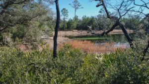
One of the most popular hikes on the Florida Trail is also one of the most interesting, and one of the more important destinations for overnight trips, with Juniper Prairie Wilderness a no-hunting zone.
The Juniper Prairie Wilderness is a designated wilderness area in the heart of the Big Scrub of the Ocala National Forest, where random camping is permitted all times of year.
No machinery is permitted in wilderness areas, so trail maintainers must hand-saw fallen trees, and tree damage can be great after a forest fire or windstorm. But scrub habitat is resilient.
This hike ties together two fascinating destinations, Pat’s Island, once a pioneer village, and Hidden Pond, a spring-fed natural oasis.
It’s a popular day trip option following a portion of the linear Florida Trail segment between Hopkins Prairie and Juniper Springs.
 Florida Trail, Juniper Springs to Hopkins Prairie 10.6 miles. Marvel at a mosaic of ancient scrub forest, vast prairies, and pine islands while crossing the Juniper Prairie Wilderness north of Juniper Springs.
Resources





Disclosure: As authors and affiliates, we receive earnings when you buy through our links. This helps us provide public information on this website.
Overview
Location: Ocala National Forest
Length: 8.4 mile round-trip
Trailhead: 29.25734,-81.681152
Fees: Free
Restroom: None
Land manager: National Forests in Florida
Phone: 352-625-2520
Carry plenty of water and use sun protection. The scrub is Florida’s desert habitat with limited shade.
This area is entirely a no-hunting zone, but we’d still recommend wearing orange Nov-Jan for your safety.
If you plan to camp in the wilderness, proper food storage and a bear canister is a must. Bears roaming the wilderness have figured out that tents mean food.
Directions
From the intersection of SR 40 and SR 19 in the Ocala National Forest (34 miles west of Interstate 95 and 37 miles east of Interstate 75), drive north 6.2 miles, passing the Juniper Wayside and then a few miles later, the entrances to Silver Glen Springs and the Yearling Trail. You’ll see a “Pat’s Island Trailhead” sign directing you to the left onto FR 46. Follow this single-lane forest road – it’s a little rugged, but passable by passenger vehicles – for 2 miles. A sign directs you into the trailhead on the right.
Hike
From the trailhead, follow the narrow path west to where it emerges at some posts along the road. The connector turns right. Turn left and cross FR 46 to walk up to the Florida Trail crossing.
Just beyond the road is a large “Juniper Prairie Wilderness” sign. Head south past it. There are tall longleaf pines in the distance signaling the edge of Pat’s Island.
It’s an island of longleaf pine and sandhill habitat amid the surrounding sea of the Big Scrub, the world’s largest sand pine scrub forest.
Pass a trail junction at a double-blazed post for the Yearling Trail, which you’ll explore on the return trip, and continue straight ahead. The scrub often grows in tightly here, forming a tunnel.
Sand pine scrub is a very flammable habitat; in fact, it requires fire to properly regenerate. The Forest Service has a “no firefighting” policy in this wilderness area.
The same goes for using power tools. So there will be times after storms the trail is a jumble of deadfall and scorched trees. When it isn’t, it’s a beautiful walk.
Treat standing dead pines and oaks near the trail as very real hazards, since they can and will fall across the footpath at some point.
Thankfully, nature heals quickly in this habitat, so understory growth is extremely dense and surviving sand live oaks are lush with leaves quickly.
Descend amid tall, unscathed longleaf pines with open grassy spots beneath them. Atop the next hill, the trail levels out in a healthy pine forest. Each of these ridges is an ancient sand dune.
This is of the rare places in Florida that the sea didn’t cover, which is why the assemblage of plants in the Big Scrub includes many rare and unusual species.
Reaching the oak-shaded top of this ridge, meet the second junction with the Yearling Trail at 0.8 mile.
Continue straight ahead, following the orange blazes towards the ridges in the distance, for a descent into the first of the prairies of the Juniper Prairie Wilderness, which has a small pond in its middle.
Florida scrub-jays are common across this part of the wilderness, large, curious blue-and-white birds adapted to this desert-like habitat.
Climbing up and over the next ancient dune, descend into a cluster of young sand pines and walk around the western edge of a larger prairie.
Note the grasses growing along the prairie rim. Sometimes these prairies are lakes, and sometimes they are dry. The trail turns right and climbs up and away from it over the next sand ridge.
Along the edges of the trail are deer moss and British soldiers, two common lichens in the Big Scrub. An impenetrable mass of young oaks crowds the understory.
Some of the larger shrubs are small by Big Scrub standards, including rusty lyonia, with its crooked branches, and silk bay, with its aromatic leaves.
Showy in springtime, bigflower pawpaw has dozens of ivory-colored blooms draping from its branches. The palmettos are a species especially adapted to dry conditions, the scrub palmetto.
Rounding a swale, climb to high ground from which you can survey more distant ridges, and continue the journey towards that line of pines to the southeast.
By 1.7 miles, enter a maturing sand pine forest. Clustered tightly together, the sand pines drop enough needles to carpet the sandy footpath.
Otherwise, most of the hiking through the Big Scrub is through soft sand like beach sand, and can become tiresome after many hours of walking. The best time to visit is after a soaking rain packs it down.
Go up and over the ridge. Reaching an oak hammock, enjoy a moment of shade before the trail turns to the right to follow the rim of a very large prairie outlined by clumps of sand cordgrass.
Climb up to the right and then makes a sharp right into another small oak hammock above a pond in a sinkhole. It may be dry, or it may have lilies on its surface.
The footpath leads you in a semi-circle around the sink atop a bluff thick with saw palmetto. From this bluff, you can see another prairie in the distance.
Making a sharp right away from the sink, the trail descends towards the next prairie’s edge, where fire-scarred trunks are all that remain of the sand live oaks that used to provide shade along the prairie rim.
At 2 miles, pass a deep pond in the prairie that persists even when water levels are extremely low. It’s covered in water lilies.
Continue uphill and turn left to curve around the pond and prairie on a bluff. Step over saw palmettos with long snaking trunks.
Leaving the deep pond behind, turn right and continue along a bluff on the rim of this large prairie system, with another large pond off to the left.
Despite their location in this desert-like habitat, these prairie ponds sometimes have alligators in residence. You’re more likely, however, to see a lot of deer tracks in the mud.
Beyond the large pond, the trail curves to the right past a swale in the landscape, a bowl of bright white sand, and climbs up the next ridge.
At 2.3 miles, you finally reach that line of pines that you kept seeing in the distance since the second intersection with the Yearling Trail.
The trail stays to the west of two prairies ringed by slash pines, which you’ll have better views of on the return trip. As the trail pulls away from these prairies, it climbs up and over the next ridge.
By 2.8 miles, reach the edge of a dry prairie edged with slash pine. Ascending the next ridge, it’s a surprise and a delight to find older sand pines and tall, spindly rusty lyonia.
Drop to the prairie’s edge again, with a view across the sometimes-dry wetland. Oaks on the prairie rim arch their limbs towards the prairie.
Continues downhill, facing a pond in the prairie, before a climb into an oak hammock, a beautiful patch of forest. Emerge onto the shore of a broad prairie that stretches off to the right.
Pass some large prickly pear cactus as you continue the climb into the diminutive scrub. Reach a high point with a sweeping vista of prairies off to the horizon.
Losing elevation, descend to your destination, Hidden Pond, at 3.6 miles. Spring-fed, Hidden Pond is tucked in a swale between the sand ridges, a basin of cool, clear water.
Long a destination for backpackers and one of the more picturesque spots along the Florida Trail, it can be far too busy on weekends. And there are bears. Smart ones. Camping elsewhere is prudent.
Step off the Florida Trail to walk around the pond clockwise; a footpath circles its rim. Enjoy several different perspectives on the pond as the trail climbs into the oak hammock.
The camping area is simply a flat cleared area under the oaks. A prairie is on the other side of this ridge, and the gradient between pond and prairie means it’s always breezy here.
It’s a nice place for a mid-hike break. While snacking, listen for the chatter of scrub-jays, as a family lives in the oaks along the pond.
Leaving the camping area, complete your full circle around Hidden Pond until you’re back to the Florida Trail. Juniper Springs is to the south, and Pat’s Island is to the north.
Turn left to start the hike back towards Pat’s Island. As you climb away from the pond, be sure you’re headed north.
At the top of this first ridge, you can see several ridges in quick succession ahead of you, and two more in the far distance to your left.
At 4.2 miles, the trail drops out of the scrub forest to face the prairie rim. Stay with the path closest to the prairie rim where worn tracks diverge.
With the prairie to your back, the trail turns right and heads up over the ridge to the next line of pines in the distance.
Reaching the bottom of the ridge, the trail turns left and weaves through the scrub, paralleling the pine-rimmed prairies to your right.
Working its way to the next ridge, the trail returns to the large prairie system with its deep pond. At 5.5 miles, it almost looks like the trail plunges straight ahead and down into the sinkhole.
Take sharp left here to stay on the bluffs above it, through the saw palmetto. Hiking north, notice several very large prickly pear cactus above the rim of the next prairie.
Turn away from the prairie and head uphill to start climbing up and over scrub ridges for a while before descending to the edge of a circular prairie.
The line of pines ahead delineates the edge of Pat’s Island. Following the grassy edge of the next prairie, climb a steep ascent to the junction with the Yearling Trail, reaching it at 6.5 miles.
Going straight ahead cuts a mile off this hike, but it’s worth the extra footsteps to learn a little about pioneer life in the Big Scrub. Turn right to continue.
Blazed yellow, the Yearling Trail leads you into the heart of Pat’s Island, a historic settlement in the Big Scrub. In the 1840s, Patrick Smith, for whom the island was named, ran the post office.
A circuit preacher from Paisley would arrive once a month to preach at the Chapel Methodist Church. At least a dozen families settled here, including Reuben and Sara Jane Long, who arrived in the fall of 1876.
It was truly’s Florida frontier, where growing sugar cane and corn, peas, beans, and watermelons, the Longs scraped out a life in a very harsh environment.
When their young son Melvin found a fawn whose mother had been killed by a bear, they allowed him to raise it. In 1938, Melvin’s brother Calvin entertained Marjorie Kinnan Rawlings for a few days.
He shared the family’s stories, inspiring The Yearling, her Pulitzer Prize winning novel. Marker 8 calls attention to a rainwater cistern, all that remains of the original Reuben Long homestead.
Drop off the ridge into a bowl of slash pines and head east through an island of sandhills. This is a beauty spot for fall wildflowers, including deer’s-tongue and yellow buttons.
Once palmetto and wiregrass form an understory beneath turkey oak and longleaf pine, you’re firmly on Pat’s Island. The trail widens to the width of a road.
This is the Old Grahamville Road, a historic wagon road connecting the original settlements of the Big Scrub. Descends through a stand of sand live oaks, reaching a trail junction at 7.4 miles.
The broad old wagon trail continues straight ahead to other points of interest, including the site of Calvin Long’s homestead, which was used as a set in the movie version of The Yearling in 1946.
Turn right at this junction to visit the Long family cemetery. It’s a quiet spot in the sandhills, still tended, with the tombstones of Reuben and Sara Jane showing their age.
Return back to the trail junction and continue straight through it on the broad path. At 7.7 miles, the trail enters a oak hammock and emerges along the rim of an enormous, deep sinkhole.
This is where the families of Pat’s Island collected their water, collected in catch basins below sheets of limestone where tiny springs once dripped.
To supplement this source, they used rainwater cisterns, and if the need arose, took a four-mile round-trip to for buckets of spring water at Silver Glen Springs.
This clearing along the sinkhole is also the intersection with Jody’s Trace, a trail that heads east to join the wagon trail and eventually reach the Yearling Trail trailhead along SR 19.
To stay on the loop around Pat’s Island, continue past the sinkhole and bear left at the junction with Jody’s Trace. Pass Marker 5, where postmaster Patrick Smith’s homestead was located.
Reach Marker 6, which corresponds to another historic road, the Major Churchill Road. Keep right and follow the footpath, leaving the leafy shade of Pat’s Island for the scrub again.
As the trail works its way through the scrubby understory, it winds through a tunnel of scrub before passing through an open area with wiregrass beneath the oaks.
By 8.2 miles, reach the trail junction with the Florida Trail. Turn right. After passing the back side of the “Juniper Prairie Wilderness” sign, cross the forest road towards the short posts to the right.
Turn right to follow the path back to the Pat’s Island trailhead, wrapping up this 8.4 mile hike.
Trail Map

Explore More!
Learn more about the Ocala section of the Florida Trail
 Florida Trail, Ocala Spanning 72.3 from the birthplace of the Florida Trail into the world’s largest sand pine scrub forest, the Ocala section is Florida’s top backpacking destination.
Slideshow
See our photos from this hike
Nearby Adventures
 The Yearling Trail On Pat's Island, discover the landscape and the history that inspired Marjorie Kinnan Rawlings to write her Pulitzer Prize-winning novel The Yearling in 1938.
 Silver Glen Springs With a strong aquamarine hue accented by refracted rainbows as sunlight plays across the ripples on its sandy bottom, Silver Glen Springs is a first-magnitude spring in the Ocala National Forest.
 Juniper Springs Experience crystalline waters emerging from the midst of the world’s largest scrub forest in a subtropical forest at Juniper Springs in the Ocala National Forest.
 Salt Springs Loop Savor the beauty of the Big Scrub and habitats along crystalline Salt Springs Run on this easy loop on the outskirts of Salt Springs.

- Baseline Trails - November 7, 2026
- Hal Scott Yellow Trail - November 3, 2026
- Hal Scott Preserve - October 28, 2026