• Skip to main content
  • Skip to header right navigation
  • Skip to after header navigation
  • Skip to site footer
Florida Hikes logo

Florida Hikes

Hike Bike Paddle Camp Florida with authors Sandra Friend and John Keatley as your guides

  • Trails
  • Maps
  • Guidebooks
  • Hike
    • Scenic Hikes
    • Loop Trails
    • Dog-friendly Hikes
    • Hikes for Kids
    • National Parks in Florida
    • Florida State Parks
  • Bike
    • Major Bike Trails
    • Paved Bike Trails
    • Off Road Biking
    • Biking Articles
  • Paddle
    • Canoe & Kayak Rentals
    • Paddling Destinations
    • Paddling Articles
  • Camp
    • Cabin Rentals
    • Car Camping
    • Primitive Camping
  • Florida Trail
    • Plan your Hike
    • Best Scenic Hikes
    • Best Backpacking
    • Section Hiking
    • Thru-Hiking
    • Trail Updates
  • Travel
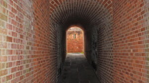
Archway at Fort Clinch

Fort Clinch Walking Tour

Roam an impressive, interpreted Third System fortress on the Florida coast along this walking tour that makes a circuit of the interior of Fort Clinch.

Fernandina Beach (30.703489, -81.453580)   0.6 miles   Fort Clinch State Park

Dominating the outflow of the St. Marys River into Cumberland Sound and the Atlantic Ocean, Fort Clinch was built for Florida’s coastal defense.

At the time the original compound was built, Fernandina Beach was a thriving Southern port troubled by both piracy and invasions. Five flags fly over the colonial city.

View from fort ramparts View of the fort and Cumberland Sound from the ramparts


An architectural gem, it incorporates elements typical of Gothic European fortresses, such as flying buttresses and hexagonal archways.

Spiral staircases seem to hang in place, and dark tunnels lined in brick invite inspection by the curious.

Spiral staircase Spiral granite staircase


While construction started in 1842, the fort was not completed until 1867, even though it was garrisoned during the Civil War.

It also served the country’s defense in the Spanish-American War. However, the United States armed forces sold it as surplus property in 1926.

Armaments in a circular brick room Keeping the ammunition dry within whitewashed brick walls


Thankfully, it was not torn down by the developer who bought it, and came into state ownership in 1935.

Laborers from the Civilian Conservation Corps worked for six years on its renovation, up until the outbreak of World War II.

Table inside brick building Dining quarters inside the garrison


As the centerpiece of Fort Clinch State Park, the fort’s role is now to interpret the past.

In doing so, it introduces you to an architectural style that is breathtaking in both its grandeur and its simplicity.

Gun portal between brick walls Peering through a gun hole to the outside of the fort


Resources

Resources for exploring the area
50 Hikes in North Florida book cover North Florida Panhandle Explorers Guide book cover Hikers Guide to the Sunshine State book cover Paddlers Guide Florida
 
Disclosure: As authors and affiliates, we receive earnings when you buy through our links. This helps us provide public information on this website.

Overview

Location: Fernandina Beach
Length: 0.6 mile loop
Trailhead: 30.703489, -81.453580
Address: 2601 Atlantic Ave, Fernandina Beach
Fees: $6 per vehicle or $4 single occupant; $2 pedestrians and cyclists. Additional $2 fee for fort tour.
Restrooms: At the visitor center where you buy tour tickets.
Land manager: Florida State Parks
Phone: 904-277-7274

Park open 8 AM to sunset daily. Pets are prohibited within the walls of the fort.

This tour is self-guided, but you are welcome to join an ad hoc group if you see one gathered around a re-enactor.

On certain weekends during the year, the fort is fully garrisoned by either Confederate or Union regiments.

Cannon aimed towards sky


Directions


From Jacksonville, follow Interstate 95 north for 20 miles to exit 373. Head east on SR 200 / A1A (Buccaneer Trail) for 10 miles, passing through Yulee and crossing the Intracoastal Waterway into Fernandina Beach on Amelia Island. Continue 2 miles as A1A curves north and merges onto South 8th St. Continue north on South 8th St for 3 miles to Atlantic Ave and turn right. Head east on Atlantic Ave for 1.5 miles. The entrance to Fort Clinch State Park will be on your left. After you stop at the ranger station and pay your park entrance fee, continue 3 miles along the main park road to the parking area at the Fort Clinch Visitor Center.

Hike

From the parking lot, walk up to the museum and bookstore and pay the $2 per person admission before entering the grounds of the fortress.

Savor the strong sea breeze as you walk across the open area leading up to the moat, and imagine walking back into 1864.

Drawbridge into fort The drawbridge over the moat


As you cross the drawbridge and enter the fort, the smell of wood smoke fills the tunnel.

Civil War-era re-enactors roam the fort, leading groups on tours or just going about their duties.

Reenactor in Union uniform in laundry room A Union soldier explains how laundry is done


Emerging from the tunnel, notice the building right in front of you, the storehouse and dispensary.

The brown brick structures around you are the original portions of the fort; the remainder was added from 1864 through 1867 by Union regiments and the Army Corps of Engineers.

Two toned brick in fort walls The lighter colored brick was in place before the Civil War


Following the Third System design of fortress building, Fort Clinch has a two wall fortification: one masonry, one earthen. Gun batteries stand on the masonry walls.

Third System fortresses such as Fort Clinch were designed as a coordinated system of coastal defenses along the southern coast of the United States in the aftermath of the War of 1812.

Panorama inside the fort A panoramic view of the fort’s interior


Walk counterclockwise around the buildings, and peek into the open interiors to see how the garrison lived.

As you walk around the enlisted men’s barracks, notice the grand pillars on the back of the building.

fireplace and jail bars A jail cell is part of the garrison quarters


Continue past the well and turn left into the long brick tunnel to access the southwest bastion of the fort.

Within this tunnel and bastion, you’ll see the very unique architectural details that make Fort Clinch a national treasure, some keen masonry tricks for roof support.

Woman in brick tunnel Incredible curved brick ceiling in a tunnel


These include flying buttresses, vaulted archways, and hexagonal archway systems, with bricks facing downward in the ceilings in some of the tunnels.

Notice the gothic pentagonal ceiling inside the bastion, eliminating the need for a central pillar.

gothic pentagonal ceiling in brick Brickwork making up the pentagonal ceiling


Climb up the extremely narrow winding granite staircase to emerge atop the bastion, where you take in a sweeping view of the fort and Cumberland Sound.

As you leave the bastion, turn left, walking out on a wooden staircase to access the earthen ramparts.

Waterfront with cedar trees from tabby and brick fortress View of Cumberland Sound from atop the walls of Fort Clinch


The guns are mounted on granite blocks atop a tabby (oyster shell and mortar) wall that tops the earthen impoundment.

As you walk along the wall, listen to the slap of waves against the jetty, and feel the sting of salt air in your face.

Cannon atop the fortress One of the many restored guns atop Fort Clinch


Beyond the Spanish bayonets, a staircase leads down to a dark chamber, another bastion at the very mouth of the river.

Descend and investigate, exploring the gothic architecture that looks out on the river and the beach.

Descent along edge of fort Descent past Spanish bayonet to a hidden chamber


As you leave, turn left to walk along the inside of the exterior scarp. You feel blasts of cold sea air as you pass each gun hole.

When you reach the staircase, turn right, and climb back up to top of the ramparts for a great view down the sweep of the beach along the Atlantic Ocean.

View from fort ramparts View of the fort and Atlantic Ocean beach from the ramparts


Walk down the broad ramp to the inner courtyard. Turn right, and check out the quarters tucked into the inside wall—the powder room, the laundry, and the medical quarters.

Cross the open green back to the last building flanking the entrance, the guard room.

Quartermaster quarters with supplies Supplies inside the Quartermaster’s quarters


When you leave the fort, continue back to the museum and take a look at the exhibits explaining the history of Fort Clinch, if you did not do so before your tour.

After an hour or so of exploring, you’ve completed a 0.6-mile walk.

Massive lock hasp An outstanding example of mid-1800s craftsmanship


Trail Map

Fort Clinch State Park Trail Map
Red: Main Loop. Blue: Beach Walk. Green/Yellow: Willow Pond Trails.

Explore More!

Learn more about Fort Clinch State Park

Parade ground inside 1800s fort Fort Clinch State Park With 1,100 acres of pristine beaches, towering dunes, maritime forest, and estuarine tidal marshes, Fort Clinch State Park is one of Florida’s paramount recreational areas.

Explore the trails of Fort Clinch State Park

Glowing green marsh Fort Clinch Willow Pond Trails Explore a coastal ridge and murky swamp along footpaths and levees around ponds created by the Civilian Conservation Corps near Fort Clinch.
Oceanfront at Fort Clinch Fort Clinch Beach Walk Explore a wave-tossed beach shoreline while searching for sea shells along the northernmost stretch of the Atlantic Coast in Florida.
Pathway skimming through hammock in golden light Fort Clinch Shared Use Trail A 6.2 mile singletrack loop shared by hikers and cyclists provides challenging slopes to climb between the edge of the estuary and a dune front.

Video

A walk through Fort Clinch


Nearby Adventures

Fernandina Plaza State Park Fernandina Plaza Historic State Park At Fernandina Plaza State Park, an unassuming open space marks the spot of Plaza San Carlos, a parade ground for the fortress that protected a fledgling city along the St. Marys River.
Massive dune with interpretive info American Beach Home to the largest dune system on the Atlantic Coast in Florida, American Beach has a rich history as a vacation destination that served the African-American community during the days of segregation in the South.
Dense upland forest John Muir Ecological Park John Muir Ecological Park in Yulee connects you to an important and mostly forgotten chapter of Florida history: our role in John Muir's "Thousand Mile Walk to the Gulf."
Canal along Egans Creek Greenway Egans Creek Greenway Northeast of Jacksonville in Fernandina Beach, Egans Creek Greenway is a protected area of over 300 acres that runs north to south along Egans Creek.

Trail Map (PDF) Reserve Campsite Official Website

  • Author
  • Recent Posts
Sandra Friend & John Keatley
Articles jointly researched, written, and photographed by Sandra Friend & John Keatley, authors and publishers of FloridaHikes.com.
Sandra Friend & John Keatley
Latest posts by Sandra Friend & John Keatley (see all)
  • Baseline Trails - November 7, 2026
  • Hal Scott Yellow Trail - November 3, 2026
  • Hal Scott Preserve - October 28, 2026
Category: Hikes, Loop Hikes, Museums, North Florida, TrailsTag: Amelia Island, Family-Friendly, Fernandina Beach, Florida State Parks, Fort Clinch State Park, Historic Sites, Living History

Sidebar

FarOut Guides

Our comprehensive trail logistics presented on offline maps:

Florida National Scenic Trail (1,500 miles)
Florida Keys Overseas Heritage Trail (108 miles)
Eastern Continental Trail in Florida (92 miles)


We earn a small commission on sales through these links. Thanks for your support!


Our Guidebooks

We’ve written Florida guidebooks for over 25 years. These include North Florida destinations.

Book cover with woman hiking through palms with baby carrier
Book cover of Florida Trail Hikes
The Florida Trail Guide fifth edition
Explorer's Guide North Florida & The Panhandle guidebook

Explore More

Newest Articles for North Florida

Deep water-filled crevices Little Awesome Preserve
Longleaf pine forest LEAFS Preserve South
Paved bike path surrounded by pines and grassy slope Lehigh Trail
Aqua blaze on pine trunk next to footpath in flatwoods Dahoma Historic Trail

  • Facebook
  • Flickr
  • Instagram
  • Pinterest
  • Substack
  • Vimeo

FIND A TRAIL OR PARK

METROS: Bradenton. Clearwater. Crestview. Daytona Beach. Destin. Fort Lauderdale. Fort Myers. Fort Walton Beach. Gainesville. Jacksonville. Kissimmee. Lakeland. Melbourne. Miami. Naples. Ocala. Orlando. Panama City Beach. Pensacola. Port St. Lucie. Punta Gorda. St. Petersburg. Sanford. Sarasota. Sebring. Stuart. Tallahassee. Tampa. Vero Beach. West Palm Beach.

MULTI-REGION: Atlantic Coastal Ridge. Atlantic Coast. Bartram Trail. Big Bend. East Coast Greenway. Everglades National Park. Florida National Scenic Trail. Gulf Coast. Lake Wales Ridge. WATERWAYS: Indian River Lagoon. Intracoastal Waterway. Kissimmee River. St. Johns River. Withlacoochee River.

NORTHWEST FLORIDA: Altha. Apalachicola. Apalachicola National Forest. Big Bend Scenic Byway. Blackwater River State Forest. Blountstown. Bonifay. Bristol. Bruce. Cantonment. Cape San Blas. Carrabelle. Chattahoochee. Chipley. Crawfordville. DeFuniak Springs. Eastpoint. Ebro. Eglin Air Force Base. Freeport. Fountain. Gulf Breeze. Gulf Islands National Seashore. Holt. Madison. Marianna. Milton. Monticello. Mossy Head. Munson. Navarre. Navarre Beach. Newport. Niceville. Panacea. Panama City . Perdido Key. Ponce De Leon. Port St. Joe. Quincy. Santa Rosa Beach. Sopchoppy. South Walton. St. George Island. St. Marks. St. Marks NWR. Sumatra. Vernon. Wakulla. Wewahitchka. Woodville. WATERWAYS: Apalachicola River. Blackwater Bay. Blackwater River. Chipola River. Choctawhatchee Bay. Choctawhatchee River. Coastal Dune Lakes. Ochlockonee Bay. Perdido River. St. Marks River. Wacissa River. Wakulla River. Yellow River.

NORTH FLORIDA: Alachua. Amelia Island. Archer. Baldwin. Branford. Bronson. Bunnell. Callahan. Cedar Key. Chiefland. Crescent City. Cross City. Cross Creek. Dowling Park. Ellaville. Fanning Springs. Fernandina Beach. Flagler Beach. Fort White. Glen St. Mary. Green Cove Springs. Hawthorne. High Springs. Inglis. Jacksonville Beaches. Jacksonville Northshore. Jasper. Jennings. Keystone Heights. Lake Butler. Lake City. Live Oak.Macclenny. Mandarin. Mayo. Mayport. Micanopy. Middleburg. Old Town. Olustee. Orange Park. Osceola National Forest. Palatka. Palatka-Lake Butler Trail. Palm Coast. Palm Valley. Perry. Ponte Vedra. Rodman. Salt Springs. St. Augustine. Starke. Steinhatchee. Suwannee. Suwannee River Wilderness Trail. Suwannee Springs. Talbot Islands. Timucuan Preserve. Trenton. Waldo. Welaka. White Springs. Williston. Worthington Springs. Yankeetown. WATERWAYS: Santa Fe River. St. Marys River. Suwannee River. Tolomato River. Upper Withlacoochee River.

CENTRAL FLORIDA: Altamonte Springs. Apollo Beach. Apopka. Astatula. Astor. Auburndale. Bartow. Babson Park. Bayport. Belleview. Bithlo. Brandon. Brooksville. Bushnell. Canaveral National Seashore. Cassadaga. Christmas. Chuluota. Citrus Springs. Clearwater Beach. Clermont. Coast to Coast Trail. Cocoa. Cocoa Beach. Cross Florida Greenway. Crystal River. Dade City. De Leon Springs. DeBary. Deland. Deltona. Dunedin. Dunnellon. Edgewater. Enterprise. Eustis. Ferndale. Fort Meade. Frostproof. Geneva. Gibsonton. Haines City. Hernando. Hernando Beach. Holopaw. Homosassa. Inverness. Kenansville. Kissimmee. Lake Mary. Lake Wales. Largo. Leesburg. Lithia. Longwood. Lutz. Maitland. Malabar. McIntosh. Melbourne Beach. Merritt Island. Merritt Island NWR. Mims. Mount Dora. Narcoossee/Lake Nona. New Port Richey. New Smyrna Beach. Nobleton. Oak Hill. Oakland. Ocala National Forest. Ocklawaha. Ocoee. Oldsmar. Orange City. Ormond Beach. Osteen. Oviedo. Paisley. Palm Bay. Plant City. Poinciana. Polk City. Ponce Inlet. Port Orange. Ridge Manor. Riverview. Ruskin. Safety Harbor. Silver Springs. Sorrento. Spring Hill. St. Cloud. Tarpon Springs. Thonotosassa. Titusville . Umatilla. Viera. Walt Disney World. Weeki Wachee. Weirsdale. Wimauma. Windermere. Winter Garden. Winter Haven. Winter Park. Winter Springs. Withlacoochee State Forest. Withlacoochee State Trail. Yeehaw Junction. Zephyrhills. WATERWAYS: Alafia River. Halifax River. Hillsborough River. Lake Apopka. Little Manatee River. Ochlawaha River. Rainbow River. Tampa Bay. Wekiva River. Wekiva River Basin.

SOUTHWEST FLORIDA: Alva. Boca Grande. Cape Coral. Charlotte Harbor. Ding Darling NWR. Ellenton. Englewood. Estero. Immokalee. Marco Island. North Port. Osprey. Palma Sola. Palmetto. Pine Island. Port Charlotte. Sanibel Island. Venice. WATERWAYS: Caloosahatchee River. Manatee River. Myakka River. Pine Island Sound.

SOUTH FLORIDA: Arcadia. Basinger. Big Cypress National Preserve. Big Cypress Seminole Reservation. Big Cypress Swamp. Bowling Green. Clewiston. Everglades City. Indiantown. LaBelle. Lake Okeechobee Scenic Trail. Lake Placid. Lakeport. Moore Haven. Okeechobee. Ortona. Pahokee. Palmdale. Port Mayaca. South Bay. Wauchula. Zolfo Springs. WATERWAYS: Fisheating Creek. Lake Okeechobee. Peace River.

SOUTHEAST FLORIDA: Biscayne Bay. Biscayne National Park. Boca Raton. Boynton Beach. Coconut Creek. Coral Gables. Coral Springs. Davie. Delray Beach. Fellsmere. Flamingo. Fort Pierce. Hobe Sound. Hollywood. Homestead. Indrio. Jensen Beach. Juno Beach. Jupiter. Jupiter Farms. Key Biscayne. North Hutchison Island. Ocean to Lake Greenway. Palm Beach. Palm Beach Gardens. Pompano Beach. Redland. Sebastian. South Hutchinson Island. WATERWAYS: Florida Bay. St. Lucie River.

FLORIDA KEYS: Big Pine Key. Islamorada. Key Largo. Key West. Marathon. Overseas Heritage Trail.


©2006-2026, Sandra Friend & John Keatley | Disclosure | Site Index | Work with Us | Advertise with Us | Terms of Service and Privacy Policy

Florida Hikes PO Box 93 Mims FL 32754 | Contact
