
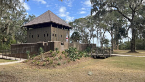
With permission from the Spanish governor, the first community at this site outside the city walls of St. Augustine founded in 1738.
Thriving under Spanish rule, the inhabitants had escaped from British colonies to the north. In 1740, they took to arms to fight off the English siege of the city.
 Fort Mose
 was destroyed. Displaced residents blended into the city. But by 1752, the new Spanish governor was troubled by the percentage of the population that was African or native.
He commanded a new settlement house them outside the city gates. Based on archaeological finds, this landscape protected by the state park encompasses that location.
 State park entrance
Two interpretive trails, the Flight to Freedom and the Walkway to Freedom, tell the story of those hardy souls who came to live at this site.
Behind a museum presenting the history of Fort Mose, a reconstructed fort beneath the ancient oaks now joins interpretive stations for living history demonstrations.
 Artifacts inside the museum
Resources





Disclosure: As authors and affiliates, we receive earnings when you buy through our links. This helps us provide public information on this website.
Overview
Location: St. Augustine
Trailhead: 29.927834,-81.325415
Address: 15 Fort Mose Trail, St. Augustine
Length: 1.1 miles
Fees: Free. $2 per person to tour the museum
Restroom: Foyer of the visitor center (closed Tue-Wed)
Land manager: Florida State Parks
Phone: 904-823-2232
Grounds open 9-5 daily. Visitor center, museum, and Walkway to Freedom fully accessible.
Visitor center, museum, and fort closed Tue-Wed. When open, hour-long tours held at 10 AM and 1 PM.
Directions
From Interstate 95 in St. Augustine, take SR 16 east 5.2 miles to US 1. Turn left. Continue 0.8 mile north to turn right on Fort Mose Trail. Follow the brown state park signs to the parking area.
Hike
To explore the park in a timeline that tracks with its history, start up the sidewalk from the parking area towards the museum.
A series of interpretive panels discuss the creation, decline, and abandonment of the colony at Fort Mose.
 Learn history along the walkway
Visiting the museum before tackling the trails provides context to this historic site. A small per-person fee applies. Take in the video overview first.
Using immersive audiovisual presentations and artifacts found on site, the exhibit hall illuminates daily life in the settlement through the eyes of its residents.
 Visitor Center and museum
The settlement persisted until 1763, when Spain ceded Florida to the British. The British still ran a slave trade across the Atlantic.
Realizing the danger of remaining here, the residents of Fort Mose largely joined the departing Spanish settlers in moving to Spanish-held Cuba.
 History through the eyes of those who lived it
Leaving the museum, follow the walkway to the left around the side of the building to the picnic area under the live oak canopy.
It is adjoined by interpretive stations occupied occasionally by living history volunteers, usually on weekends or during special events.
 Interpretive station
Leave the sidewalk for a counterclockwise stroll along the clearing surrounding the replica fort to pass a dugout canoe in progress, one of the demonstrations.
Make a beeline for the boardwalk to the floating dock in the estuary and walk out to the dock at its end.
 Boardwalk
It’s the best location in the park for viewing a large rookery on an island in the marshes of the Tolomato River basin.
The treetops remain busy and noisy in early spring when egrets and wood storks nest and raise their young.
 The island on the right houses the rookery
Leaving the boardwalk, walk up to the replica of Fort Mose. When it is open, you can explore its interior.
Interpretive signs outside explain its fortifications and the village that would have surrounded it.
 Interpretation of the village site
Behind it is the trailhead for the Flight to Freedom. After reading the introductory interpretive panel, follow the arrows to go counterclockwise around this hard-packed graded loop.
Each panel along the walk through the lush hardwood hammock dramatizes stops along the flight of a runaway slave to the safe haven of Fort Mose.
 Flight to Freedom trailhead
Enjoy the shade of spreading live oaks and enormous Southern magnolias, a counterpoint to the sobering history presented.
There are details on the Yamasee tribe, the slave catchers, and the Franciscan friars who assisted runaway slaves at the cost of religious conversion.
 Lush forest
Walk past the fort and museum to return to the parking area for a second interpretive trail, the accessible Walkway to Freedom.
Pass under its prominent archway to start the boardwalk extending into the Tolomato River estuary.
 Walkway to Freedom arch
Reach the first of two observation decks hovering over a salt creek flowing through a brackish needlerush marsh.
Birders will appreciate the clear panoramas of marsh and forest edge. Interpretive markers call attention to specifics about the habitat.
 Above a salt creek
The boardwalk spans a tidal creek and salt ponds. A slender peninsular ridge extends into the estuary from the portion of the park behind the museum.
Pass through this treed area of cedars, sand live oaks, and yaupon holly, another excellent spot for birding.
 Red-bellied woodpecker
Opening up into the marsh again, the boardwalk showcases the panorama across the marshes towards Vilano Beach.
The observation deck at its end overlooks where the two eras of Fort Mose once stood, the second version confirmed with archaeological digs.
 End of the boardwalk
An interpretive panel shows the locations relative to this observation deck.
Backtrack your route along the boardwalk, reaching the parking area at 1.1 miles to complete your circuit of this state park.
 Returning through the estuary
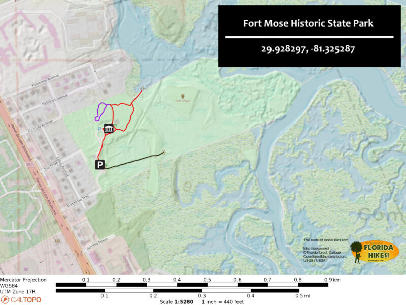
Trail Map
Explore More!
Video
A walk through Fort Mose Historic State Park
Slideshow
See our photos from Fort Mose Historic State Park
Nearby Adventures
 Stokes Landing Conservation Area Fronting a vast estuary along the Tolomato River basin, Stokes Landing Conservation Area contrasts deeply shaded maritime hammock and marsh rims with panoramic views.
 Castillo de San Marcos The only remaining 17th century fortress in North America, the Castillo de San Marcos defended the Spanish colony of St. Augustine from two British sieges in the 1700s.
 Fish Island Preserve Only a few miles from downtown St. Augustine, a set of well-marked paths explore shady hammocks and expansive salt marshes on the grounds of a former orange plantation.
 Nocatee Preserve A linear buffer between a massive planned community and the Tolomato River in Palm Valley, Nocatee Preserve protects 2,400 acres of riverfront habitats north of St. Augustine.

- Hal Scott Yellow Trail - November 3, 2026
- Hal Scott Preserve - October 28, 2026
- Tradewinds Park - October 27, 2026