• Skip to main content
  • Skip to header right navigation
  • Skip to after header navigation
  • Skip to site footer
Florida Hikes logo

Florida Hikes

Hike Bike Paddle Camp Florida with authors Sandra Friend and John Keatley as your guides

  • Trails
  • Maps
  • Guidebooks
  • Hike
    • Scenic Hikes
    • Loop Trails
    • Dog-friendly Hikes
    • Hikes for Kids
    • National Parks in Florida
    • Florida State Parks
  • Bike
    • Major Bike Trails
    • Paved Bike Trails
    • Off Road Biking
    • Biking Articles
  • Paddle
    • Canoe & Kayak Rentals
    • Paddling Destinations
    • Paddling Articles
  • Camp
    • Cabin Rentals
    • Car Camping
    • Primitive Camping
  • Florida Trail
    • Plan your Hike
    • Best Scenic Hikes
    • Best Backpacking
    • Section Hiking
    • Thru-Hiking
    • Trail Updates
  • Travel
Steep climb past a tree with a red blaze

Graham Swamp East Hiking Trail

A surprisingly rugged hike along a ridgetop threads between two sides of a mountain bike loop on the eastern side of Graham Swamp Preserve.

Palm Coast (29.508319, -81.161709)   2.2 miles   Graham Swamp Preserve

Is it a natural feature, or man-made? The ridge running along the eastern side of Graham Swamp has elements that lean both ways.

While it feels a lot like the diggings of the Cross Florida Greenway, it drops off precipitously towards the swamp, providing outstanding views of the floodplain below.

Ridge with view of swamp below View into the floodplain


Yet it is topped with well-established habitats, including sandhill with towering pines and scrub trees of uncommonly large size.

Spills of limestone boulders, metal dragline cables embedded in the earth, and deep cuts holding water add the likelihood of mine tailings from nearby operations.

Trail winding up a hillside Hillside with boulders


No matter its origin, the ridge sets the stage for a fantastic hike on a linear footpath flanked by a popular mountain bike loop, with intersections occuring only at both ends.

Signage encourages hikers to make a loop of it using the paved Graham Swamp Trail as a return route, but this 1.1 mile roller-coaster of a hike is too much fun not to hike twice.

Furrow in pine needle covered hill Furrowed descent near the north end of the trail


Resources

Resources for exploring the area
50 Hikes in North Florida book cover North Florida Panhandle Explorers Guide book cover Hikers Guide to the Sunshine State book cover Paddlers Guide Florida
 
Disclosure: As authors and affiliates, we receive earnings when you buy through our links. This helps us provide public information on this website.

Overview

Location: Palm Coast
Length: 2.2 miles
Trailhead: 29.508319, -81.161709
Address: 5135 Colbert Ln, Palm Coast
Fees: Free
Restroom: Portable toilet at trailhead
Land Manager: Flagler County
Phone: 386-313-4020

Open sunrise to sunset. Leashed dogs welcome; pick up after your pet.


Directions


From Flagler Beach / Bunnell exit 284 off Interstate 95 at SR 100, drive east 1.8 miles, passing under the Graham Swamp Trail bridge before reaching the light at Colbert Ln. Turn left and drive north on Colbert Ln, passing the Lehigh Trail trailhead after 1.9 miles. Continue another half mile to the Graham Swamp East trailhead, which is also on the left.


Hike

A large kiosk with trail map and signs for the hiking trail guide you through the pass-through at the corner of the parking area.

Start uphill on a moderately steep path under the cedars and oaks, crossing the bike trail twice in quick succession.

Trailhead kiosk and signage Start your hike here


Reach the relatively flat top of the ridge, where slash pines and oaks define the sandhill habitat. Coontie peeps from the pine duff.

Curving north upon nearing the west side of the ridge, peer into the floodplain forest of Graham Swamp below, largely cypress and red maples.

Pine forest with more ghostly forest beyond Top of the ridge facing west towards the floodplain


Under towering slash pines on the ridgetop, immerse in the sandhills, the sandy path easy to follow but also marked with red blazes and occasional blue metal hiker markers.

Where the path nudges closer to the edge of the ridge, it’s striking to see the distinct difference in habitats from this perspective.

Trail as tunnel under trees Scrub tunnel


A subtle shift to scrubby flatwoods occurs. The myrtle oaks under the pines are quite sizable, as robust silk bays, some standing nearly to twenty feet tall.

Tunnel under a succession of scrub oaks, silk bays, and red cedars, emerging into another patch of sandhill with tall skinny pines.

Tall pines and oaks on ridge Ridgetop sandhills


Cross an old two-track access road at 0.2 mile. Slipping through a patch of scrub oaks, the footpath narrows into a furrow.

Curving through a stand of young pines into a switchback downhill. A footbridge crosses the low spot.

Murky ditch Murky ditch


A murky ditch beyond the paralleling bike path must occasionally spill over to the swamp, posing the question whether this divot out of the ridge this is a natural feature.

Discovering many ancient dragline cables embedded in the earth, we think limestone was intentionally removed from this ridge by a mining operation.

Furrowed path to top of hill Climbing to the ridgetop


Ascend out of the basin, using roots as stairsteps on the climb to the ridge top. Slash pines and a turkey oak signal sandhills yet scrub oaks and silk bay hem in the trail corridor.

Step over the first of the ancient dragline cables, its wound metal wiring taut like a tree root.

Thick metal cable in footpath Cable embedded in the footpath


A long, straight plunge through a low dip in the ridge is followed by a steeply winding ascent.

Where the ridge narrows, the paralleling singletrack remains close by but does not cross the trail. Rimmed with moss, chunks of limestone jut from the foopath.

Trail dips through forest ahead Plunge through a dip


By a half mile, ascend to a height where the slash pines tower over the oaks once more.

Rounded and grassy, the sweep of the hillside dropping to the swamp feels more natural. Spanish moss drapes from bluejack oaks.

Grassy hillside in forest Grassy hillside sloping to Graham Swamp


Follow minor twists and turns punctuated by straightaways. The understory opens up briefly on the approach to a stand of ancient saw palmetto and columns of pines.

Traverse mild hills on the ridgetop beneath the pines with occasional steep climbs.

Footpath climbing roots Mild step-up


Views into Graham Swamp become more common, the footpath cut as sidehill on an approach to a climb through folded terrain.

Descend a rocky slope with roots as stairsteps, the steepest grade thus far on a drop into a large basin.

Stairsteps of roots under pines It’s steeper than it looks


At the bottom, bridges on the singletrack loop flank the footpath, which crosses a rock-and-gravel bridge over an ephemeral waterway.

A finger of the wetland within Graham Swamp extends into view this carve-out in the ridge.

Red blazed trail uphill Climb out of the basin


At 0.8 mile, climb out of the basin on a straightforwardly steep run to the top of the ridge.

The forest is very different here: the setting park-like with an open understory, the hillsides sweeping gently towards the base of the ridge and views of the swamp.

If cyclists are on the singletrack, you’re most likely to notice them whizzing by in this area.

Grassy hilltop under oaks On the hilltop


Descend through the pines, noting exposed cables. Large boulders of limestone are strewn across the forest floor, adding to the mining theory.

The habitat shifts to sandhills again, with some of the pines once deeply cut with catfaces to tap for turpentine.

Pine tree with deep gash Catfaced pine


Another park-like setting emerges, the open understory making it easy to look out over the swamp.

Descend a furrowed grade beneath the pines, a straightaway leading to an intersection with signage at the final crossing of the singletrack loop at 1.1 miles.

Signs at trail junction Signage at the junction


Walk a causeway between two ponds to the fence along Colbert Lane where signage points right for a 1.1 mile walk along the Graham Swamp Trail back to the trailhead.

Since that paved route is entirely in the sun, we chose to retrace our steps with a round-trip traverse of the ridge, experiencing the descents and climbs in a different sequence.

Gate in wooded shade with sign pointing towards parking lot Trail’s end at a gate to a paved segment of the Graham Swamp Trail


Returning through the woods provided better views of Graham Swamp, too, and more attentiveness to artifacts and unusually large silk bays.

Whichever route you choose, return to the Graham Swamp East trailhead to complete the 2.2 mile hike.

Swamp trees framed by pine trunks Looking across Graham Swamp near the 2 mile mark on a ridgetop return


Trail Map
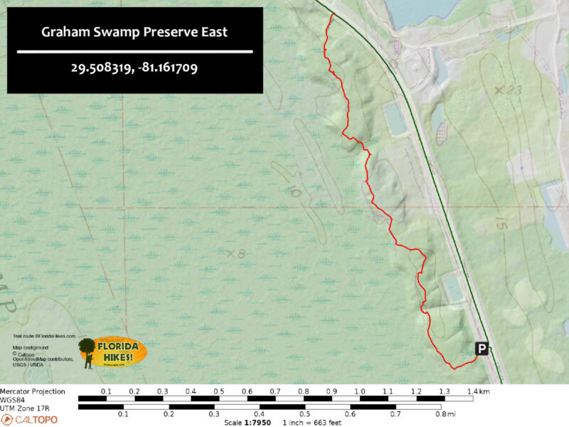
Graham Swamp East Hiking Trail Map


Explore More!

Learn more about Graham Swamp Preserve

Pine ridge with floodplain forest below Graham Swamp Preserve A freshwater swamp forest less than two miles from the Atlantic Ocean, Graham Swamp Preserve is where Bulow Creek rises to flow south.

Video

Hiking Graham Swamp East


Slideshow

See our photos from Graham Swamp East


Nearby Adventures

Path under pines and magnolias Graham Swamp West On a mile hike within sand pine scrub and a lush swamp forest, circle two placid blackwater ponds on the western side of Graham Swamp.
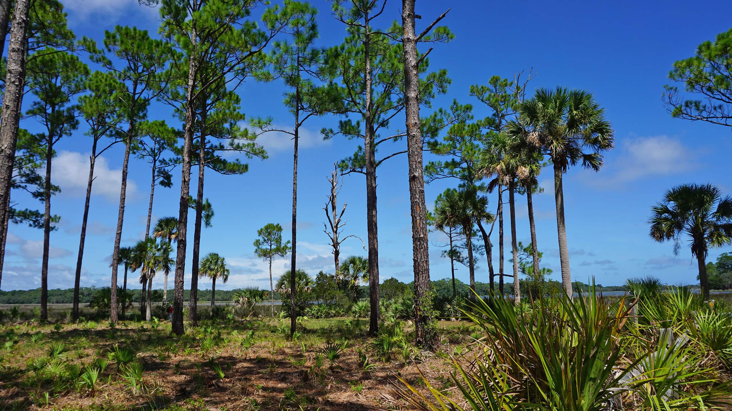
Pines along a coastal estuary Princess Place Preserve Explore wild spaces and cultivated grounds along eight different trails at Princess Place Preserve, an 1880s homestead at Cherokee Grove on Pellicer Creek.
Pine flatwoods Faver-Dykes State Park At Faver-Dykes State Park, explore the estuaries of the Matanzas River and the uplands above Pellicer Creek.
swampy trail Bulow Woods Bulow Woods Loop In a primordial forest of sluggish, fern-lined waterways amid a dense forest of massive, ancient trees, the 5.2 mile Bulow Woods Loop is one of North Florida's most scenic hikes.

Official Website

  • Author
  • Recent Posts
Sandra Friend
Sandra Friend
Author of 45 books, Sandra Friend established FloridaHikes.com in 2006 to expand on the field research she'd completed for her first six hiking guides. She has been honored with lifetime achievement awards from the Florida Trail Association and the Florida Outdoor Writers Association.
Sandra Friend
Latest posts by Sandra Friend (see all)
  • Michael Crotty Bicentennial Park - November 3, 2026
  • A.J. Henry Park - November 1, 2026
  • Okeeheelee Nature Center Trails - October 22, 2026
Category: County Parks, Day Hikes, Hikes, Loop Hikes, Natural Lands, North Florida, TrailsTag: Botanical, Bunnell, Flagler Beach, Geology, Graham Swamp, Hilly Trails, Palm Coast, Scenic Hikes

Sidebar

FarOut Guides

Our comprehensive trail logistics presented on offline maps:

Florida National Scenic Trail (1,500 miles)
Florida Keys Overseas Heritage Trail (108 miles)
Eastern Continental Trail in Florida (92 miles)


We earn a small commission on sales through these links. Thanks for your support!


Our Guidebooks

We’ve written Florida guidebooks for over 25 years. These include North Florida destinations.

Book cover with woman hiking through palms with baby carrier
Book cover of Florida Trail Hikes
The Florida Trail Guide fifth edition
Explorer's Guide North Florida & The Panhandle guidebook

Explore More

Newest Articles for North Florida

Deep water-filled crevices Little Awesome Preserve
Longleaf pine forest LEAFS Preserve South
Paved bike path surrounded by pines and grassy slope Lehigh Trail
Aqua blaze on pine trunk next to footpath in flatwoods Dahoma Historic Trail

  • Facebook
  • Flickr
  • Instagram
  • Pinterest
  • Substack
  • Vimeo

FIND A TRAIL OR PARK

METROS: Bradenton. Clearwater. Crestview. Daytona Beach. Destin. Fort Lauderdale. Fort Myers. Fort Walton Beach. Gainesville. Jacksonville. Kissimmee. Lakeland. Melbourne. Miami. Naples. Ocala. Orlando. Panama City Beach. Pensacola. Port St. Lucie. Punta Gorda. St. Petersburg. Sanford. Sarasota. Sebring. Stuart. Tallahassee. Tampa. Vero Beach. West Palm Beach.

MULTI-REGION: Atlantic Coastal Ridge. Atlantic Coast. Bartram Trail. Big Bend. East Coast Greenway. Everglades National Park. Florida National Scenic Trail. Gulf Coast. Lake Wales Ridge. WATERWAYS: Indian River Lagoon. Intracoastal Waterway. Kissimmee River. St. Johns River. Withlacoochee River.

NORTHWEST FLORIDA: Altha. Apalachicola. Apalachicola National Forest. Big Bend Scenic Byway. Blackwater River State Forest. Blountstown. Bonifay. Bristol. Bruce. Cantonment. Cape San Blas. Carrabelle. Chattahoochee. Chipley. Crawfordville. DeFuniak Springs. Eastpoint. Ebro. Eglin Air Force Base. Freeport. Fountain. Gulf Breeze. Gulf Islands National Seashore. Holt. Madison. Marianna. Milton. Monticello. Mossy Head. Munson. Navarre. Navarre Beach. Newport. Niceville. Panacea. Panama City . Perdido Key. Ponce De Leon. Port St. Joe. Quincy. Santa Rosa Beach. Sopchoppy. South Walton. St. George Island. St. Marks. St. Marks NWR. Sumatra. Vernon. Wakulla. Wewahitchka. Woodville. WATERWAYS: Apalachicola River. Blackwater Bay. Blackwater River. Chipola River. Choctawhatchee Bay. Choctawhatchee River. Coastal Dune Lakes. Ochlockonee Bay. Perdido River. St. Marks River. Wacissa River. Wakulla River. Yellow River.

NORTH FLORIDA: Alachua. Amelia Island. Archer. Baldwin. Branford. Bronson. Bunnell. Callahan. Cedar Key. Chiefland. Crescent City. Cross City. Cross Creek. Dowling Park. Ellaville. Fanning Springs. Fernandina Beach. Flagler Beach. Fort White. Glen St. Mary. Green Cove Springs. Hawthorne. High Springs. Inglis. Jacksonville Beaches. Jacksonville Northshore. Jasper. Jennings. Keystone Heights. Lake Butler. Lake City. Live Oak.Macclenny. Mandarin. Mayo. Mayport. Micanopy. Middleburg. Old Town. Olustee. Orange Park. Osceola National Forest. Palatka. Palatka-Lake Butler Trail. Palm Coast. Palm Valley. Perry. Ponte Vedra. Rodman. Salt Springs. St. Augustine. Starke. Steinhatchee. Suwannee. Suwannee River Wilderness Trail. Suwannee Springs. Talbot Islands. Timucuan Preserve. Trenton. Waldo. Welaka. White Springs. Williston. Worthington Springs. Yankeetown. WATERWAYS: Santa Fe River. St. Marys River. Suwannee River. Tolomato River. Upper Withlacoochee River.

CENTRAL FLORIDA: Altamonte Springs. Apollo Beach. Apopka. Astatula. Astor. Auburndale. Bartow. Babson Park. Bayport. Belleview. Bithlo. Brandon. Brooksville. Bushnell. Canaveral National Seashore. Cassadaga. Christmas. Chuluota. Citrus Springs. Clearwater Beach. Clermont. Coast to Coast Trail. Cocoa. Cocoa Beach. Cross Florida Greenway. Crystal River. Dade City. De Leon Springs. DeBary. Deland. Deltona. Dunedin. Dunnellon. Edgewater. Enterprise. Eustis. Ferndale. Fort Meade. Frostproof. Geneva. Gibsonton. Haines City. Hernando. Hernando Beach. Holopaw. Homosassa. Inverness. Kenansville. Kissimmee. Lake Mary. Lake Wales. Largo. Leesburg. Lithia. Longwood. Lutz. Maitland. Malabar. McIntosh. Melbourne Beach. Merritt Island. Merritt Island NWR. Mims. Mount Dora. Narcoossee/Lake Nona. New Port Richey. New Smyrna Beach. Nobleton. Oak Hill. Oakland. Ocala National Forest. Ocklawaha. Ocoee. Oldsmar. Orange City. Ormond Beach. Osteen. Oviedo. Paisley. Palm Bay. Plant City. Poinciana. Polk City. Ponce Inlet. Port Orange. Ridge Manor. Riverview. Ruskin. Safety Harbor. Silver Springs. Sorrento. Spring Hill. St. Cloud. Tarpon Springs. Thonotosassa. Titusville . Umatilla. Viera. Walt Disney World. Weeki Wachee. Weirsdale. Wimauma. Windermere. Winter Garden. Winter Haven. Winter Park. Winter Springs. Withlacoochee State Forest. Withlacoochee State Trail. Yeehaw Junction. Zephyrhills. WATERWAYS: Alafia River. Halifax River. Hillsborough River. Lake Apopka. Little Manatee River. Ochlawaha River. Rainbow River. Tampa Bay. Wekiva River. Wekiva River Basin.

SOUTHWEST FLORIDA: Alva. Boca Grande. Cape Coral. Charlotte Harbor. Ding Darling NWR. Ellenton. Englewood. Estero. Immokalee. Marco Island. North Port. Osprey. Palma Sola. Palmetto. Pine Island. Port Charlotte. Sanibel Island. Venice. WATERWAYS: Caloosahatchee River. Manatee River. Myakka River. Pine Island Sound.

SOUTH FLORIDA: Arcadia. Basinger. Big Cypress National Preserve. Big Cypress Seminole Reservation. Big Cypress Swamp. Bowling Green. Clewiston. Everglades City. Indiantown. LaBelle. Lake Okeechobee Scenic Trail. Lake Placid. Lakeport. Moore Haven. Okeechobee. Ortona. Pahokee. Palmdale. Port Mayaca. South Bay. Wauchula. Zolfo Springs. WATERWAYS: Fisheating Creek. Lake Okeechobee. Peace River.

SOUTHEAST FLORIDA: Biscayne Bay. Biscayne National Park. Boca Raton. Boynton Beach. Coconut Creek. Coral Gables. Coral Springs. Davie. Delray Beach. Fellsmere. Flamingo. Fort Pierce. Hobe Sound. Hollywood. Homestead. Indrio. Jensen Beach. Juno Beach. Jupiter. Jupiter Farms. Key Biscayne. North Hutchison Island. Ocean to Lake Greenway. Palm Beach. Palm Beach Gardens. Pompano Beach. Redland. Sebastian. South Hutchinson Island. WATERWAYS: Florida Bay. St. Lucie River.

FLORIDA KEYS: Big Pine Key. Islamorada. Key Largo. Key West. Marathon. Overseas Heritage Trail.


©2006-2026, Sandra Friend & John Keatley | Disclosure | Site Index | Work with Us | Advertise with Us | Terms of Service and Privacy Policy

Florida Hikes PO Box 93 Mims FL 32754 | Contact
