• Skip to main content
  • Skip to header right navigation
  • Skip to after header navigation
  • Skip to site footer
Florida Hikes logo

Florida Hikes

Hike Bike Paddle Camp Florida with authors Sandra Friend and John Keatley as your guides

  • Trails
  • Maps
  • Guidebooks
  • Hike
    • Scenic Hikes
    • Loop Trails
    • Dog-friendly Hikes
    • Hikes for Kids
    • National Parks in Florida
    • Florida State Parks
  • Bike
    • Major Bike Trails
    • Paved Bike Trails
    • Off Road Biking
    • Biking Articles
  • Paddle
    • Canoe & Kayak Rentals
    • Paddling Destinations
    • Paddling Articles
  • Camp
    • Cabin Rentals
    • Car Camping
    • Primitive Camping
  • Florida Trail
    • Plan your Hike
    • Best Scenic Hikes
    • Best Backpacking
    • Section Hiking
    • Thru-Hiking
    • Trail Updates
  • Travel
Path through pine flatwoods

Hal Scott Red Trail

Traversing savannas and flatwoods with an open ranchland feel, the 6.2 mile Red Trail circles the north part of Hal Scott Preserve.

Bithlo (28.49245, -81.12371)   10.2 miles   Hal Scott Preserve

Edging the east side of the Econlockhatchee River floodplain, the Red Trail starts north of the 4 mile White Trail.

To reach it from the south requires fording a frequently flooded tributary of the Econlockhatchee River.

Water pooling in front of a red blaze The ford


An alternate access from the north – a 4.4 mile loop through Pine Lily Preserve and Long Branch – enables hikers to keep their feet dry. Largely.

Two drainage canals slice across this landscape, connecting the Wedgefield subdivision off SR 520 to the river.

Red blaze along canal stretching into the distance Path along drainage canal


Formerly ranchland, the landscape was drained long ago and is largely dry pine flatwoods.

However, its landscapes are lush with seasonal wildflowers, including tiny bogs where pitcher plants and pine lilies flourish.

purple flowers clustered on shrub in pine flatwoods False foxglove blooms in fall


Resources

Resources for exploring the area
Hikers Guide to the Sunshine State book cover 5 Star Trails Orlando 50 Hikes in Central Florida Central Florida Orlando Explorers Guide book cover The Florida Trail Guide book cover Florida Trail Hikes book cover
 
Disclosure: As authors and affiliates, we receive earnings when you buy through our links. This helps us provide public information on this website.

Overview

Location: Bithlo
Length: Up to 10.2 miles
Trailhead: 28.486333, -81.095833
Address: 5150 Dallas Blvd, Bithlo
Fees: Free
Restroom: None
Land Manager: St. Johns Water Management District
Phone: 386-329-4404

Open sunrise to sunset. Cyclists and equestrians share the trails.

Leashed dogs welcome if the trail is accessed from the White Trail. Dogs are not permitted in Pine Lily Preserve.


Directions


From SR 436 at the Orlando International Airport, take toll SR 528 (Beachline Expressway) east to Exit 24, Dallas Blvd. Turn left and drive 2.4 miles to the park entrance on the left. You must hike the White Trail to reach the Red Trail. To reach this loop from the north, see the Pine Lily-Long Branch Loop.

Hike

From the main parking area, round the gate and walk west along the two-track to the preserve kiosk. Take a map or photo of the map posted on it.

Reaching the White Trail junction at a double diamond blaze, turn right to walk it counterclockwise, quickly rising into a pine savanna.

Grassy open pine savanna Pine savanna


Rounding a curve to sweep west, enter a vast palmetto prairie. Carnivorous plants thrive amid well-hidden bogs in the wiregrass.

Drop through several low spots. At 1.1 miles, a stream seasonally trickles through a narrow drainage. The trail draws closer to a distant treeline on the horizon.

Close up of small bog with thread-leaf sundew and hooded pitcher plants  Carnivorous plant bog


At 2 miles, meet the start of the Red Trail at a T intersection. Turn right to follow the red diamonds towards the treeline.

Inside this ribbon of trees, a creek flows towards Econlockhatchee River. Gravel undergirds the path, which may require a wade.

Red blaze on pine where trail enters treeline Entering the hammock


After the creek crossing, emerge out of the forested swale, rising up to the signposted Red Trail loop junction.

Take the east side into the pine flatwoods, passing a wooden rain shelter.

Trail junction with red signage Loop junction


Expect a profusion of wildflowers through this stretch each fall, from the waving stalks of blazing star to rosinweed and delicate narrow-leaved sabatia.

Turning toward the east-west Nettleton Canal a mile north of the loop junction, cross culverts to its north side.

Broad canal stretching into distance Nettleton Canal


Reaching a power transmission line, make a sharp right turn to head east beneath it.

After slightly less than a half mile, the trail makes a sharp a north turn to enter a pine-dotted savanna.

double red blaze beneath powerline Powerline


At 4.6 miles, reach the east-west canal that marks the north boundary of Hal Scott Preserve.

Yellow diamonds mark the junction with the Pine Lily-Long Branch Loop, which heads south and east from here.

Red blaze visible beyond foreground yellow diamonds Pine Lily-Long Branch Loop junction


Turn left to follow the Red Trail west, paralleling the south side of the canal along a grassy stretch for the next mile.

Leaving the canal where it filters into the floodplain forest to the west, make a sharp left south into the pine flatwoods.

Double diamond on tree with forest beyond Reaching the northwest corner of the loop


The west side of the loop skims close to the Econlockhatchee River floodplain. The old ranch road it follows may get soggy.

Turn left with the red diamonds under the power lines 7 miles into the hike. In the opposite direction, a path leads 0.4 miles to a walk-in entrance from a subdivision.

Bright red lily bloom with yellow center Trailside pine lily


Within a quarter mile, turn south to cross the Nettleton Canal again. Immerse in the pine flatwoods, where pine lilies bloom late fall.

Winding through the pine flatwoods, seal the 6.2 mile loop of the Red Trail after 8.2 miles. Continue straight ahead to the creek crossing.

Winding grassy two track amid pines Pine flatwoods


At the White Trail junction, you have two choices. A left retraces the 2 mile route through the palmetto prairie and pine savanna.

For a more immersive walk in the pine savanna or to add on all or part of the Yellow Trail), continue straight ahead. Reach the Yellow Trail junction in a half mile.

Routed wooden sign Yellow Trail junction


To stay on the White Trail, make a left. In a little over a half mile, pass the junction to the group camp.

After two distinct curves, seal the White Trail loop and follow the straightaway to the trailhead to wrap this 10.2 mile hike.

Pine savanna beyond routed wood 1 mile sign Reaching the final mile


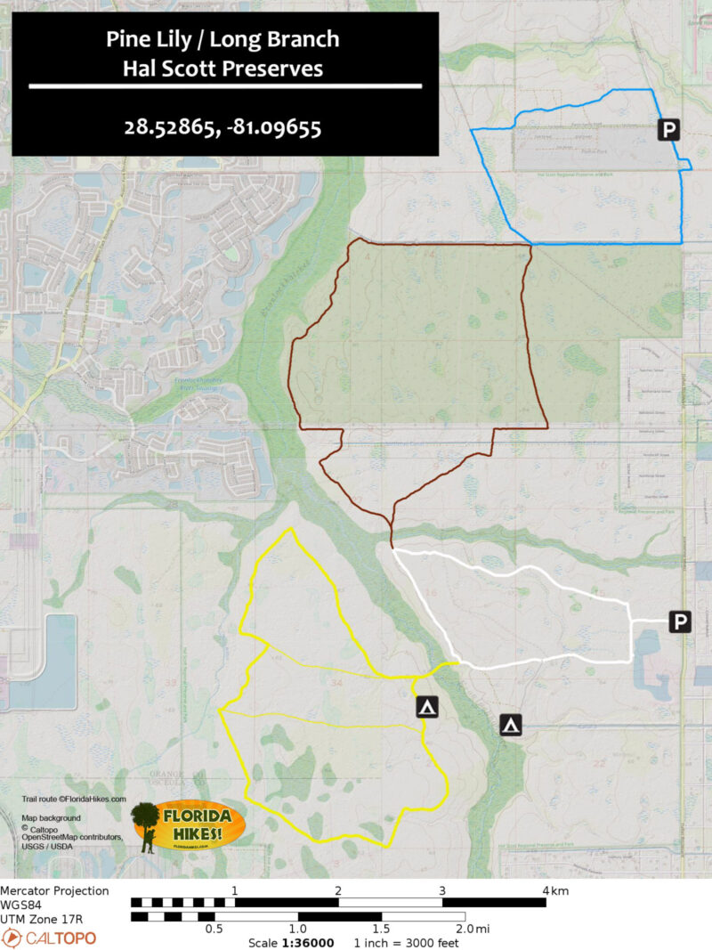
Trail Map

Hal Scott plus Connectors Trail Map
White: White Trail. Yellow: Yellow Trail. Brown: Red Trail. Blue: Pine Lily-Long Branch Loop.

Explore More!

More hiking in Hal Scott Preserve

Young longleaf pines at Hal Scott Hal Scott Preserve Explore vast prairies and seepage bogs, cross the Econ River at Curry Ford, and camp under a live oak canopy—all just east of the Orlando International Airport.
Two-track through pine savanna Hal Scott Yellow Trail Vibrant wildflowers blossom amid seasonally wet flatwoods and pine savannas on this lengthy loop west of the Econlockhatchee River in Hal Scott Preserve.

Adjoining public lands accessible from the Red Trail

Florida myrtle blooming next to a trail with a puddle Pine Lily Preserve In every season, wildflowers are the highlight along more than 4 miles of trails at Pine Lily Preserve, where its namesake lilies bloom in late summer.
Shady path with a bright blaze on a tree Long Branch More than 6 miles of interconnected trails east of the Econlockhatchee River explore natural habitats on ranch land undergoing habitat restoration.


Slideshow

See our photos from the Red Trail


Nearby Adventures

Lilies on a pond Hidden Pond Preserve Putting together several loops providing perspectives on pine flatwoods, prairie, swamp, and a showy pond, Hidden Pond Preserve offers a very enjoyable 1.9 mile hike.
Archway of oaks above forest of moss Econlockhatchee Sandhills CA In the floodplain of the Econlockhatchee River, Econlockhatchee Sandhills Conservation Area is a 706-acre showcase of upland habitat diversity with a 3.2 mile loop trail.
Pine flatwoods panorama Savage Christmas Creek Preserve Protecting more than a thousand acres, Savage Christmas Creek Preserve east of Orlando has more than 8 miles of trails through panoramic prairie and pine flatwoods landscapes.
Pine-palm flatwoods Tosohatchee WMA Protecting more than 30,000 acres of the St. Johns River floodplain near Christmas, Tosohatchee WMA is a place to immerse yourself in the grandeur of old Florida and its bounty of botanical beauty.

Trail Map (PDF) Official Website

  • Author
  • Recent Posts
Sandra Friend & John Keatley
Articles jointly researched, written, and photographed by Sandra Friend & John Keatley, authors and publishers of FloridaHikes.com.
Sandra Friend & John Keatley
Latest posts by Sandra Friend & John Keatley (see all)
  • Hal Scott Red Trail - November 13, 2026
  • Baseline Trails - November 7, 2026
  • Hal Scott Yellow Trail - November 3, 2026
Category: Biking, Central Florida, Day Hikes, Equestrian, Hikes, Loop Hikes, Natural Lands, Off Road Biking, Trails, Water Management AreasTag: Birding, Bithlo, Botanical, Dog-friendly, Econlockhatchee River, Hal Scott Preserve, Orlando, Wildflowers, Wildlife Viewing

Sidebar

FarOut Guides

Our comprehensive trail logistics presented on offline maps:

Florida National Scenic Trail (1,500 miles)
Florida Keys Overseas Heritage Trail (108 miles)
Eastern Continental Trail in Florida (92 miles)


We earn a small commission on sales through these links. Thanks for your support!


Our Florida Guidebooks

We’ve written Florida guidebooks for over 25 years. These include Central Florida destinations.

Book cover with woman hiking through palms with baby carrier
Book cover of Florida Trail Hikes
The Florida Trail Guide fifth edition
50 Hikes in Central Florida 3rd edition

Explore More

Newest Articles for Central Florida

Grassy slope edged with trees Sandhill Preserve
Two-track through pine savanna Hal Scott Yellow Trail
Footpath through coastal hammock Michael Crotty Bicentennial Park
Young longleaf pines at Hal Scott Hal Scott Preserve

  • Facebook
  • Flickr
  • Instagram
  • Pinterest
  • Substack
  • Vimeo

FIND A TRAIL OR PARK

METROS: Bradenton. Clearwater. Crestview. Daytona Beach. Destin. Fort Lauderdale. Fort Myers. Fort Walton Beach. Gainesville. Jacksonville. Kissimmee. Lakeland. Melbourne. Miami. Naples. Ocala. Orlando. Panama City Beach. Pensacola. Port St. Lucie. Punta Gorda. St. Petersburg. Sanford. Sarasota. Sebring. Stuart. Tallahassee. Tampa. Vero Beach. West Palm Beach.

MULTI-REGION: Atlantic Coastal Ridge. Atlantic Coast. Bartram Trail. Big Bend. East Coast Greenway. Everglades National Park. Florida National Scenic Trail. Gulf Coast. Lake Wales Ridge. WATERWAYS: Indian River Lagoon. Intracoastal Waterway. Kissimmee River. St. Johns River. Withlacoochee River.

NORTHWEST FLORIDA: Altha. Apalachicola. Apalachicola National Forest. Big Bend Scenic Byway. Blackwater River State Forest. Blountstown. Bonifay. Bristol. Bruce. Cantonment. Cape San Blas. Carrabelle. Chattahoochee. Chipley. Crawfordville. DeFuniak Springs. Eastpoint. Ebro. Eglin Air Force Base. Freeport. Fountain. Gulf Breeze. Gulf Islands National Seashore. Holt. Madison. Marianna. Milton. Monticello. Mossy Head. Munson. Navarre. Navarre Beach. Newport. Niceville. Panacea. Panama City . Perdido Key. Ponce De Leon. Port St. Joe. Quincy. Santa Rosa Beach. Sopchoppy. South Walton. St. George Island. St. Marks. St. Marks NWR. Sumatra. Vernon. Wakulla. Wewahitchka. Woodville. WATERWAYS: Apalachicola River. Blackwater Bay. Blackwater River. Chipola River. Choctawhatchee Bay. Choctawhatchee River. Coastal Dune Lakes. Ochlockonee Bay. Perdido River. St. Marks River. Wacissa River. Wakulla River. Yellow River.

NORTH FLORIDA: Alachua. Amelia Island. Archer. Baldwin. Branford. Bronson. Bunnell. Callahan. Cedar Key. Chiefland. Crescent City. Cross City. Cross Creek. Dowling Park. Ellaville. Fanning Springs. Fernandina Beach. Flagler Beach. Fort White. Glen St. Mary. Green Cove Springs. Hawthorne. High Springs. Inglis. Jacksonville Beaches. Jacksonville Northshore. Jasper. Jennings. Keystone Heights. Lake Butler. Lake City. Live Oak.Macclenny. Mandarin. Mayo. Mayport. Micanopy. Middleburg. Old Town. Olustee. Orange Park. Osceola National Forest. Palatka. Palatka-Lake Butler Trail. Palm Coast. Palm Valley. Perry. Ponte Vedra. Rodman. Salt Springs. St. Augustine. Starke. Steinhatchee. Suwannee. Suwannee River Wilderness Trail. Suwannee Springs. Talbot Islands. Timucuan Preserve. Trenton. Waldo. Welaka. White Springs. Williston. Worthington Springs. Yankeetown. WATERWAYS: Santa Fe River. St. Marys River. Suwannee River. Tolomato River. Upper Withlacoochee River.

CENTRAL FLORIDA: Altamonte Springs. Apollo Beach. Apopka. Astatula. Astor. Auburndale. Bartow. Babson Park. Bayport. Belleview. Bithlo. Brandon. Brooksville. Bushnell. Canaveral National Seashore. Cassadaga. Christmas. Chuluota. Citrus Springs. Clearwater Beach. Clermont. Coast to Coast Trail. Cocoa. Cocoa Beach. Cross Florida Greenway. Crystal River. Dade City. De Leon Springs. DeBary. Deland. Deltona. Dunedin. Dunnellon. Edgewater. Enterprise. Eustis. Ferndale. Fort Meade. Frostproof. Geneva. Gibsonton. Haines City. Hernando. Hernando Beach. Holopaw. Homosassa. Inverness. Kenansville. Kissimmee. Lake Mary. Lake Wales. Largo. Leesburg. Lithia. Longwood. Lutz. Maitland. Malabar. McIntosh. Melbourne Beach. Merritt Island. Merritt Island NWR. Mims. Mount Dora. Narcoossee/Lake Nona. New Port Richey. New Smyrna Beach. Nobleton. Oak Hill. Oakland. Ocala National Forest. Ocklawaha. Ocoee. Oldsmar. Orange City. Ormond Beach. Osteen. Oviedo. Paisley. Palm Bay. Plant City. Poinciana. Polk City. Ponce Inlet. Port Orange. Ridge Manor. Riverview. Ruskin. Safety Harbor. Silver Springs. Sorrento. Spring Hill. St. Cloud. Tarpon Springs. Thonotosassa. Titusville . Umatilla. Viera. Walt Disney World. Weeki Wachee. Weirsdale. Wimauma. Windermere. Winter Garden. Winter Haven. Winter Park. Winter Springs. Withlacoochee State Forest. Withlacoochee State Trail. Yeehaw Junction. Zephyrhills. WATERWAYS: Alafia River. Halifax River. Hillsborough River. Lake Apopka. Little Manatee River. Ochlawaha River. Rainbow River. Tampa Bay. Wekiva River. Wekiva River Basin.

SOUTHWEST FLORIDA: Alva. Boca Grande. Cape Coral. Charlotte Harbor. Ding Darling NWR. Ellenton. Englewood. Estero. Immokalee. Marco Island. North Port. Osprey. Palma Sola. Palmetto. Pine Island. Port Charlotte. Sanibel Island. Venice. WATERWAYS: Caloosahatchee River. Manatee River. Myakka River. Pine Island Sound.

SOUTH FLORIDA: Arcadia. Basinger. Big Cypress National Preserve. Big Cypress Seminole Reservation. Big Cypress Swamp. Bowling Green. Clewiston. Everglades City. Indiantown. LaBelle. Lake Okeechobee Scenic Trail. Lake Placid. Lakeport. Moore Haven. Okeechobee. Ortona. Pahokee. Palmdale. Port Mayaca. South Bay. Wauchula. Zolfo Springs. WATERWAYS: Fisheating Creek. Lake Okeechobee. Peace River.

SOUTHEAST FLORIDA: Biscayne Bay. Biscayne National Park. Boca Raton. Boynton Beach. Coconut Creek. Coral Gables. Coral Springs. Davie. Delray Beach. Fellsmere. Flamingo. Fort Pierce. Hobe Sound. Hollywood. Homestead. Indrio. Jensen Beach. Juno Beach. Jupiter. Jupiter Farms. Key Biscayne. North Hutchison Island. Ocean to Lake Greenway. Palm Beach. Palm Beach Gardens. Pompano Beach. Redland. Sebastian. South Hutchinson Island. WATERWAYS: Florida Bay. St. Lucie River.

FLORIDA KEYS: Big Pine Key. Islamorada. Key Largo. Key West. Marathon. Overseas Heritage Trail.


©2006-2026, Sandra Friend & John Keatley | Disclosure | Site Index | Work with Us | Advertise with Us | Terms of Service and Privacy Policy

Florida Hikes PO Box 93 Mims FL 32754 | Contact