
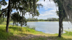
Donated by Mosaic, the current name for the mining operation that started along the Peace River basin in the 1950s, this county park encompasses a surprising 1,200 acres.
Along the Paynes Creek floodplain to the eastern edge of the pits, the landscape is forested. It’s otherwise largely open and grassy. Expect to see sandhill cranes browsing open areas.
 Deer Lake
Camping, fishing, and trail riding are the top reasons to head out to this rural corner of rural Hardee County, where farms, ranches, and mines are the closest neighbors.
It’s the closest campground to Paynes Creek Historic State Park. Assuming little light pollution at night, it may should excellent starry skies on a campout.
 Campsites near the lakeshore
Resources





Disclosure: As authors and affiliates, we receive earnings when you buy through our links. This helps us provide public information on this website.
Overview
Location: Bowling Green
Entrance: 27.61353, -81.96570
Address: 5502 Ollie Roberts Rd, Bowling Green
Fees: $5 per vehicle
Restroom: At campground and trailheads
Land Manager: Hardee County
Phone: 863-767-1100
Open 7 AM to 8 PM. Leashed pets welcome. No alcohol. Expect golf carts and ATVs on site. Neither are permitted on the equestrian trails.
Directions
From US 17 in Bowling Green, follow Main Street (CR 664) west for 8.1 miles. At a T intersection just past railroad tracks at CR 663, turn left. Drive a quarter mile and make a right on Ollie Roberts Rd. The park is on the right with a gate under the oaks after 1.3 mile, with an entrance station where day use and camping fees are collected.
About the Park
Beyond the entrance station, pay attention to signage or you will go around in circles, literally. Lake Hardee and Deer Lake have an unpaved loop drive around them.
A one-way road branching off the main entrance road accesses the day use area on Lake Hardee.
 Loop drive along Deer Lake
Picnic pavilions are in several locations along this lake, with the largest near the boat launch.
Adjoining the restrooms near the launch is a seasonal splash pad. FWC manages the lakes, so freshwater catch-and-release is the reason a lot of campers come here.
Put in a kayak, take a small boat out into the lake, or fish from the shoreline, current Florida fishing license required.
 Hand launch at the campground
Camping
North of the launch and west of Deer Lake, there are 60 campsites in the campground plus a group campsite and 15 primitive campsites for tent campers.
The prettiest portion of the campground edges the lake rim, with sites shaded by sand live oaks and pines.
 Campsite along Deer Lake
It’s an easy walk to the shoreline for fishing, with several piers provided. The piers make good observation points for birders, too.
Camping costs $20 for primitive sites, $25 for sites with 30/50 amp electric. Three bathhouses and a dump station are provided. Quiet time for campers is 10 PM – 8 AM.
 Camping for RVs and equestrians is behind the lakefront section but visible from it
Trails
Signage and maps promised trails, which is why we came here. The best option for hikers didn’t pan out. The boardwalk built here is closed, seemingly abandoned.
We found this very unfortunate, since according to their website an observation tower is along it, and this trail network leads to a more natural corner of the park.
With the boardwalk blocked off, we didn’t try to find our way in to the trails along the Paynes Creek basin. Nothing near it suggested it would reopen.
 Closed boardwalk
Another marked path for hikers and cyclists starts not far inside the park gates. The map shows it looping Lake Hardee but we couldn’t find it along the crossing between the lakes.
Gravel-surfaced for bikes and motorized wheelchairs, it weaves along the western side of the lake through a lightly forested shoreline.
Access points are along the southern side of the unpaved road looping the lake, the day use area on the one-way road, and the large parking area by the boat launch.
 Cyclists on the path by Lake Hardee
Narrow unpaved roads circle both Lake Hardee and Deer Lake and can be walked or biked as well as driven.
A network of equestrian trails starts from the northernmost camping area, the optimal destination for campers bringing their horses.
 Dirt road leading towards Gator Lake
These circle Lake Firefly and make a loop to the east of Gator Lake. Ask at the gate for a map or download one in advance.
Campers are allowed to bring ATVs and golf carts, but driving them on the equestrian or hiking/biking trails is prohibited. All rules pertaining their use must be followed.
 Directional signage
Trail Map

Explore More!
Video
Slideshow
See our photos from Hardee Lakes County Park
Nearby Adventures
 Paynes Creek Historic State Park Straddling the former treaty boundary of Seminole lands, this interpretive site along the Peace River features a network of trails tied together by a swinging footbridge.
 Alafia River State Park Alafia River State Park lets you launch on a Florida downhill while mountain biking the rugged terrain of a reforested open pit mine.
 Lake Manatee State Park With a natural lakefront stretching three miles along the edge of Lake Manatee, this state park outside Bradenton is a quiet place to camp, fish, and hike
 Brownville Park Upriver from Arcadia, this 75-acre county park in the Peace River floodplain with fascinating geologic features centers on camping, paddling, and fossil hunting.

- Baseline Trails - November 7, 2026
- Hal Scott Yellow Trail - November 3, 2026
- Hal Scott Preserve - October 28, 2026