

Many years ago, Hillsborough County ended drive-in access to Dead River Park and eliminated its campground. The park, however, didn’t disappear.
Instead, it became a conservation park within the vast wildlife corridor of Lower Hillsborough Wilderness Preserve, thousands of acres managed by state and county agencies.
 Riverside bench in Dead River Park
Its trails are still in place. To visit it, however, you’ll need to bike or walk in from the south end of neighboring Hillsborough River State Park.
Coming in from the state park, the Wetlands Trail crosses the Model Dairy Wetlands, a huge floodplain restoration project.
Outside the state park, this route continues into Dead River Conservation Park, winding along the river before looping back to reach the northern terminus of the Fort King Trail.
 Interpretive sign at the Model Dairy Wetlands
Resources





Disclosure: As authors and affiliates, we receive earnings when you buy through our links. This helps us provide public information on this website.
Overview
Location: Thonotosassa
Length: 5.5 mile loop
Trailhead: 28.137639, -82.231306
Address: 15302 US 301 North, Thonotosassa
Fees: $4-6 per vehicle
Restrooms: No
Land managers: Florida State Parks, Hillsborough County
Phone: 813-688-9500 (State Park), 813-987-6208 (County Park)
Open sunrise to sunset. Leashed dogs welcome.
Directions
From Interstate 75 exit 265 (Fowler Ave) head east on SR 582 E for 1 mile, then turn left onto US 301 N. Continue on US 301 N for 8 miles. Passing Dead River Rd on the left, keep alert for a turn onto a dirt road (Model Dairy Rd) a mile past it. Continue 0.1 mile to the Fort King trailhead. If you reach the main entrance to Hillsborough River State Park, you missed the turnoff.
Hike
Starting at the Fort King Trailhead, follow a mowed path behind the covered pavilion to grassy two-track trail.
Reaching an intersection with the Wetlands Trail at 0.1 mile, stay straight to continue towards the loop.
Turning right here leads 0.4 mile to the Wetlands Trail trailhead along the main road at Hillsborough River State Park, an alternate approach to this loop.
 Fort King Trailhead
This loop begins at 0.8 mile, where the trail forks to the north and south. Turn right to begin a counterclockwise trek.
Mesic flatwoods slowly transition to a hydric hammock as the pathway draws closer to the river floodplain.
 Trail fork
A sign at 1.4 miles indicates the boundary between the two properties where a fence gap allows passage into Dead River Park.
In a quarter mile, glimpses of the Hillsborough River can be seen through breaks in the dense vegetation lining the banks.
 Park boundary
Shade is abundant as the trail winds along next the river under branches draped heavily in Spanish moss within a dense oak and palm hammock.
Huge fronds of cabbage palms line the corridor alongside wild coffee, catbrier, and a variety of mixed trees.
 Hydric hammock
Where significant openings in the dense vegetation allow for unobstructed views of the river, benches provide a spot to rest and reflect as songbirds chirp in the canopy above.
At 2.9 miles, the trail emerges from the forest into a clearing at the end of the former Dead River Park access road.
 Hillsborough River
To the south, a red wooden bridge crosses over a tributary to the river next to a canoe launch.
Follow the dirt road eastward along a series of bends leading away from the river.
 Wooden bridge
Reaching a junction with the Fort King Trail at 4.7 miles, continue straight for 0.2 mile. The trail turns left and re-enters Hillsborough River State Park.
Tall grasses border the wide pathway as it winds through old agricultural fields, passing a covered bench along the way.
 Covered bench
Concluding the loop at 5.1 miles, follow the Fort King Trail back past its junction where the Wetlands Trail splits off to the left.
Continue straight ahead to the trailhead to complete this 5.5 mile hike.
 Wild coffee along the Wetlands Trail
Trail Map
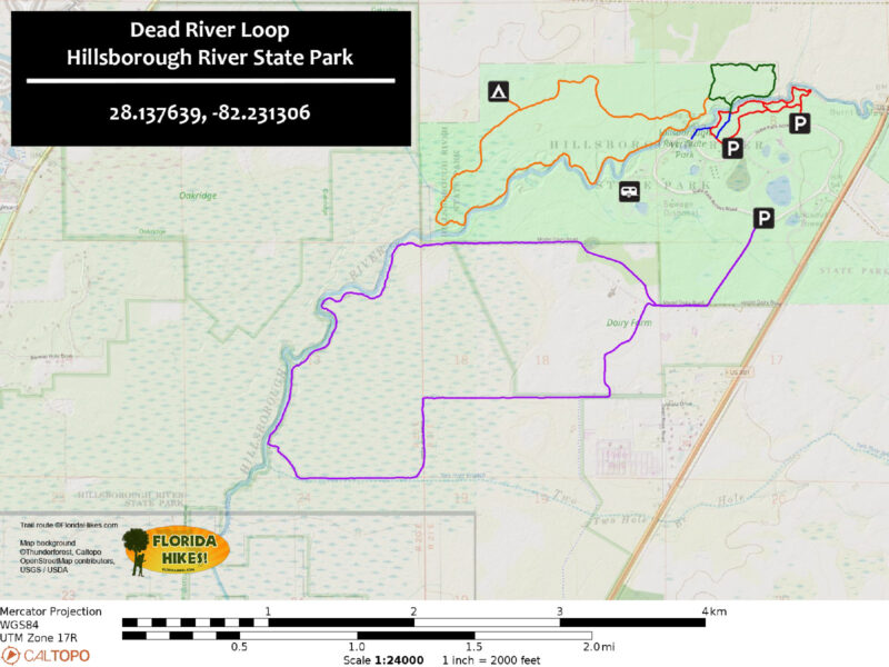
Explore More!
Learn more about Hillsborough River State Park
 Hillsborough River State Park With footpaths and picnic grounds built by the Civilian Conservation Corps, this park delights with miles of scenic trails, a swinging bridge, and the froth of river rapids.
Learn more about Lower Hillsborough Wilderness Preserve
 Lower Hillsborough Wilderness Preserve As the largest natural area in the Tampa Bay region, Lower Hillsborough Wilderness Preserve is a major destination for recreation, with seven entrances across 16,000 acres.
Video
A walk through the Hillsborough Dead River Loop
Nearby Adventures
 Oak Ridge Tract A mosaic of cypress swamps, pine flatwoods, and sandhills, the Oak Ridge Tract of Lower Hillsborough Wilderness Preserve offers immersive day hiking with many route options.
 Cypress Creek Nature Preserve A short drive from downtown Tampa, Cypress Creek Nature Preserve is an interesting window into a gradient of ecosystems along a tributary of the Hillsborough River.
 Flatwoods Park In addition to the 6.9 mile paved bike path loop at its core, Flatwoods Park at Lower Hillsborough Wilderness provides many different routes for outdoor exploration.
 Upper Hillsborough River Hiking Trail Following the north side of a blackwater river toward its headwaters, the Upper Hillsborough River Hiking Trail meanders though pine flatwoods, shady hammocks, and forested wetlands.

- Calusa Heritage Trail - November 5, 2026
- Scherer Thaxton Preserve - October 21, 2026
- Little Awesome Preserve - October 19, 2026