
A meandering, tannic, and narrow waterway, the Braden River adds a great deal of humidity to its surroundings.
This humidity nourishes the lush growth of bromeliads in the oak hammock along the river bluffs
 Braden River
A graded, reinforced shell path runs the length of the preserve to a back gate that’s within an easy walk of famed Linger Lodge, a fish camp established in 1945.
It morphed into a quirky restaurant with a large collection of diamondback rattlesnakes taxidermied decades ago by its owner.
 Inside Linger Lodge
It was in the pine flatwoods near the lodge that those massive rattlers thrived.
With the flatwoods now largely subdivisions, Johnson Preserve contains the most healthy patch of it remaining.
 Pine flatwoods
Resources





Disclosure: As authors and affiliates, we receive earnings when you buy through our links. This helps us provide public information on this website.
Overview
Location: Bradenton
Length: 1.1 miles
Trailhead: 27.42101, -82.44309
Address: 9906 Clubhouse Dr, Bradenton
Fees: Free
Restroom: At trailhead
Land Manager: Manatee County
Phone: 941-748-4501
Open sunrise to sunset. Leashed dogs welcome. Foot traffic only.
Directions
From Interstate 75 in Bradenton, take exit 217 to follow SR 70 east. In 1.1 miles, turn right on Braden Run. Make the first left onto 59th Ave E. Continue 1.2 miles through the subdivision to where the road makes a 90-degree turn left. At that turn, the trailhead is on the right.
Hike
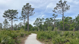
Starting adjacent to the kiosk behind the picnic shelter, the main trail into Johnson Preserve is a streak of white leading into the longleaf pine flatwoods.
The surrounding subdivision melts away quickly behind a distant screen of oaks.
 Entry kiosk
An open understory of saw palmetto allows for views well ahead. Tufts of wiregrass adjoin sprays of pennyroyal.
Bracken fern rises from the pine duff. A mingling of bay trees along the oak perimeter speaks to a marshy area hidden by vegetation.
 Path into the flatwoods
As the trail hooks towards the river, more understory plants intrude among the palmetto, from gallberry and lyonia to grapevines.
The oak hammocks press closer. At a quarter mile, a bench at a curve marks the return loop. Pass by the grassy side trail for now to continue along the shellrock path.
 Curve past the bench
Continue around the next curve, leaving the pine flatwoods behind for the shade of an oak hammock. Mature saw palmettos make up most of the understory.
A tenth of a mile beyond the bench, turn left onto an unmarked but very obvious natural surface path into the hammock.
 Spur path on left
Cabbage palms and hickories adjoin the trail as it appraches its end on a bluff above the Braden River.
A bench overlooks the tannic but clear water below, which seemed perfectly still, without a flow.
 Path to river
Boaters on the lower portion of the Braden River put in at Jiggs Landing, an entry point into a broad section called Ward Lake.
In reality, it’s a reservoir behind a dam, and that reservoir is tapped for the city’s drinking water.
The lack of free flow during a dry season may contribute to the river’s seeming stagnance.
 Bench on river bluff
Return up this side trail to the main shell path. A half mile into the hike is your first decision point: return or go on?
Making a left, the route becomes a walk among the live oaks, pines and palms interspersed.
 Into the pine-palm flatwoods
Study the oak branches swaddled in bromeliads to pick out the distinctive shapes of butterfly orchid leaves; the flowers bloom in summer.
At a curve with an arrow, a sign warns against proceeding straight ahead towards a house.
 Live oaks
Continue around the bend to where the trail meets the driveway to the home. At 0.6 mile, it’s a good turn-around point. The preserve boundary isn’t far beyond.
Past it, the back gate to the road leading to Linger Lodge is 0.2 miles ahead, a 1.2 mile round trip from this turn-around point.
 Turn-around point
Turn around and follow the shell path out of the hammock, passing the side trail to the river.
Coming to the curve into the flatwoods, veer right onto a natural surface path just before the bench.
 Path next to the bench
Meander along the edge of the river hammock to an open area where a path leads right.
Descending, it reaches a clearing adjacent to a swampy cove on the Braden River.
The path seems to continue on through a ditch filled with cypress knees. That portion was under construction during our visit to restore a launch pont for kayakers.
 Swampy cove
Turn around at the cove and climb out of the basin towards the tall longleaf pines.
Bear right along the edge of the clearing to follow a well-worn footpath along the park’s perimeter.
 Path along perimeter fence
On the right, adjoining backyards are largely obscured by the forest. To the left, the pine flatwoods stretch on and on.
Past a man-made pond on the opposite side of the fence, reach the trailhead to complete this 1.1 mile hike.
 Trailhead
Trail Map

Explore More!
Video
Hiking Johnson Preserve
Slideshow
See our photos from Johnson Preserve
Nearby Adventures
 Lake Manatee Trails Explore the open uplands inside the main entrance of Lake Manatee State Park with a trio of trails that make a 2.5 mile loop around the campground.
 Lake Manatee Gopher Trail On the east side of Lake Manatee State Park, the Gopher Trail system offers scenic views of the lake among a variety of natural habitats.
 South Fork State Park A series of three loops tied together across Little Manatee River Southfork Tract and South Fork State Park explore progressively wilder scrub communities along the South Fork of the Little Manatee River.
 Wingate Creek State Park Named after a blackwater stream at the headwaters of the Myakka River, Wingate Creek State Park showcases natural scrub communities home to the rare and endangered Florida scrub-jay.

- Michael Crotty Bicentennial Park - November 3, 2026
- A.J. Henry Park - November 1, 2026
- Okeeheelee Nature Center Trails - October 22, 2026