
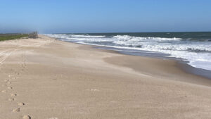
Spanning nearly 13 miles between Apollo Beach and Playalinda beach at Canaveral National Seashore, Klondike Beach is the most remote hike along the Atlantic Ocean in Florida.
Hiking along it is truly a backcountry experience within a picturesque coastal habitat. With some pre-planning and shuttling, it can be done as a long linear beach walk, or enjoyed on a round-trip from either trailhead.
Either way, the remote nature of this area is immediately apparent when passing the backcountry sign about a half mile into the hike.
 Klondike Beach
Resources





Disclosure: As authors and affiliates, we receive earnings when you buy through our links. This helps us provide public information on this website.
Overview
Location: Canaveral National Seashore
Length: 12.8 miles linear or 9 miles round-trip
Trailhead: 28.858222, -80.776583
Address: 7611 S. Atlantic Ave, New Smyrna Beach
Fees: $25 per vehicle for a 7-day visit
Restrooms: Restroom at the visitor center, vault toilet at the trailhead
Land manager: National Park Service
Phone: 386-428-3384
Open 6 AM-6 PM winter and 6 AM– 8 PM summer. Dogs are not allowed on the beach. A backcountry permit is required for this hike.
The hike is in full sun for the entire length. Be prepared with sun protection and plenty of water. Arrive early as possible to start and to obtain parking.
The route is on a sloped beach for most of the length and should be considered a very strenuous hike. Important factors to consider before starting are wind direction and tides.
Although the starting point can be at Apollo or Playalinda Beach, this article is written from north to south, beginning at Apollo Beach.
At both ends of the hike, the last boardwalk at both beaches is often frequented by nudists. A large sign on the drive to the beach reiterates this.
Directions
To Apollo Beach: From Interstate 95 in New Smyrna Beach, head east on SR 44 for 4 miles until the road becomes Lytle Ave. In 0.4 mile, continue onto S Causeway after crossing US 1 on a bridge. In 1.8 miles the road becomes S Atlantic Ave as it turns south to follow the coastline. Continue for 7.3 miles to the ranger station, and then another 6.4 miles to the end of the road at Parking Area 5.
To Playalinda Beach: From Interstate 95 in Titusville, head east on SR 406 (Garden St) for 2.8 miles, continuing straight where it becomes A. Max Brewer Memorial Pkwy after crossing US 1. Continue eastward for 8.2 miles to the ranger station, and then another 7.6 miles on the main park road to the end of the road at Parking Area 13.
Hike
Two options for exploring Klondike Beach are presented at Parking Area 5 on Apollo Beach.
At the end of the road, a steep boat ramp leads down to the Indian River Lagoon, where an access road leads south along the shoreline.
In the past, visitors could use the access road to travel the entire length between Apollo and Playalinda. A series of storms washed out portions of the dunes and the road along with it.
 Apollo Beach at dawn
This wide pathway continues south for 4.5 miles, passing through clusters of wildflowers and mangrove forests.
It then reaches a turnaround point where the road abruptly ends at the back side of a dune. Return along it for a 9 mile round-trip hike on the lagoon side of Klondike Beach.
 Coral bean and moonflowers
Because the dunes are protected and foot traffic across them is prohibited, it is necessary to begin on the beach side if you plan to hike through to Playalinda Beach.
At Parking Area 5, a sturdy boardwalk crosses a thicket of sea grapes and palmettos to the Atlantic Ocean.
To begin the hike to Playalinda, use the boardwalk crossover to access a steeply sloped coastline where plovers skitter back and forth with each wave that laps the shore.
 Klondike Beach
As the boardwalk gradually disappears in the distance behind you, the Atlantic Ocean appears more expansive.
It stretches across the horizon alongside a sandy strand with no visible structures in any direction.
Pods of pelicans soar across in V shaped formations, occasionally gliding a few feet above the water, as curled waves seem to follow behind them.
Terrestrial crabs in a variety of sizes quickly dart across the sand to hide in their burrows from potential predators.
 Camouflaged land crab
Shortly after the five-mile mark, a small shack comes into view along the shore.
An outpost for researchers, this building is an official biological field station complete with a covered porch and chairs.
Conveniently located near the halfway point, it is a great spot to stop for a break or take refuge from a storm. It also makes a good turnaround point for a round-trip hike.
 Biological field station
Painted stakes with dates written on them dot the sandy landscape, denoting sea turtle nests and the time at which researchers found them.
Alongside some of these markers, large pieces of driftwood, buoys, and odd debris wash ashore, emphasizing the remoteness of this beach.
 Ocean debris
Glimpses of the Indian River Lagoon appear over the dunes around the nine mile mark where the barrier island is particularly slim. Some sections seem only a few hundred feet across.
Skimmers and terns huddle together near the shallow waters of the lagoon, forming large congregations alongside pelicans, cormorants, herons, and roseate spoonbills.
 Indian River Lagoon
Shortly after reaching twelve miles, the probability of encountering beachgoers gradually increases as the solitude of Klondike Beach is left behind.
Passing the backcountry permit sign on the south end, continue for 0.4 mile before ending the hike at the boardwalk crossover to Parking Area 13.
 Backcountry sign
Trail Map

Explore More!
Learn more about Canaveral National Seashore
 Canaveral National Seashore Canaveral National Seashore protects 58,000 acres of maritime hammocks, dunes, and coastline north of Cape Canaveral, a natural sandy cape that formed where ocean currents meet.
Video
A walk along Klondike Beach
Nearby Adventures
 Playalinda Beach At the south end of Canaveral National Seashore, Playalinda Beach is a popular destination for beachgoers along the Space Coast thanks to its natural beaches and views of Kennedy Space Center.
 Castle Windy At Canaveral National Seashore, Castle Windy is the only trail that takes you from the Atlantic Ocean to the Indian River Lagoon, a shady walk through a coastal hammock to a windswept shoreline.
 Merritt Island National Wildlife Refuge With recreational activities ranging from hiking to biking, boating, fishing, and bioluminscent kayaking, Florida's top destination for birding is also home to Kennedy Space Center.
 Florida Coast to Coast Trail With a corridor spanning more than 220 miles across nine Florida counties, the Florida Coast to Coast Trail (C2C) is Central Florida's long distance bike path.

- Calusa Heritage Trail - November 5, 2026
- Scherer Thaxton Preserve - October 21, 2026
- Little Awesome Preserve - October 19, 2026