
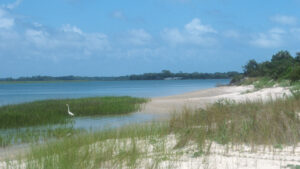
Less than a mile long, the Campground Nature Trail is an interpretive loop near the campground’s boat launch at Little Talbot Island State Park.
Restricted to campground guests, it’s a family-friendly version of the Dune Ridge Trail, climbing through relict dunes topped with forest along the edge of Myrtle Creek.
 Myrtle Creek
Resources



Disclosure: As authors and affiliates, we receive earnings when you buy these through our links. This helps us provide public information on this website.
Overview
Length: 0.8 mile loop
Trailhead: 30.4566,-81.4216
Address: 12157 Heckscher Dr, Jacksonville
Fees: $5 per vehicle
Restroom: At the beach parking area
Land manager: Florida State Parks
Phone: 904-251-2320
Open 8 AM to sunset. Leashed dogs welcome except on beaches.
Directions
From Jacksonville, drive north via I-295E over the Dames Point Bridge and exit at Heckscher Dr (SR 105). Drive east. After the highway passes the Mayport Ferry dock 9 miles into the drive, the road becomes A1A. Continue 5 more miles to the campground entrance on the left. You must be a camper with an access code to open the gate. Drive through the campground and park at the canoe launch. Walk back up to site 39; the trail starts across from it at the sign.
Hike
The Campground Nature Trail starts directly across from site 39, at a trailhead sign with a box full of maps.
Follow the white blazes down a well-defined footpath, winding through cedars and large slash pines.
Emerge on edge of the marsh, with fiddler crabs scuttling out of your way. An osprey wings by, a mullet firmly gripped in its talons.
 Berries on a cedar tree
At the trail junction, continue straight towards the next white blaze. A short spur trail leads to the marsh edge, where hundreds of fiddler crabs scurry at your footfalls into the dark juncus.
These salt-loving rushes are a member of the lily family, and come into bloom with tiny flowers like miniature lilies.
Turning away from the marsh, the trail rises into a stand of cedars before it swings back out to give another broad view of marsh.
 Marsh view
Curving left, it follows the edge of a patch of sea oxeye towards a forest of extremely gnarled live oaks, thickly draped in Spanish moss and resurrection fern.
During high tide, the marsh may invade the footpath. The trail curves away from the marsh into a dense forest of yaupon holly, red bay, and cedar, continuing into a stand of slash pines.
A faint trail leads left up a tall dune. Continue straight. At 0.6 mile, emerge into a short stretch of blinding white sand.
 Small dune
An arrow confirms the route, the trail dropping into a thicket of young cabbage palms under live oaks and wax myrtle.
It continues to lose elevation while approaching the sweep of the marsh. Merging back to your starting point, the trail completes the loop.
Turn right to exit, then left onto the campground road to return to the canoe launch parking area, finishing a 0.8-mile hike.
 Beach on Myrtle Creek
Trail Map

Explore More!
Learn more about Little Talbot Island State Park
 Little Talbot Island State Park One of the closest wild beaches to Jacksonville, Little Talbot Island State Park provides a front-row seat to the tumultous flow of Fort George Inlet into the Atlantic Ocean.
Slideshow
See our photos of the Campground Nature Trail
Nearby Adventures
More worth exploring while you’re in this area.
 Dune Ridge Trail Expect some elevation change along the Atlantic Coast on this traverse of coastal habitats that includes the tall oceanfront dunes and the beach itself.
 Big Talbot Big Pine Trail The southernmost trail on Big Talbot Island is a short walk out to a bluff above the Simpson Creek estuary through a coastal hammock riffled by breezes.
 Big Talbot Black Rock Trail An unusual and picturesque geologic anomaly, Blackrock Beach at Big Talbot Island is covered with formations that look like black lava rocks but are made of sand.

- Michael Crotty Bicentennial Park - November 3, 2026
- A.J. Henry Park - November 1, 2026
- Okeeheelee Nature Center Trails - October 22, 2026