
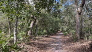
Along A1A in a beautifully canopied portion of Hammock, the Mala Compra Greenway encompasses the footprint of a former roadside attraction south of Marineland.
Ideal for hiking, a broad 1.5 mile linear doubletrack extends the length of the greenway from walk-in entry points off A1A and 16th Rd East.
 John at the 16th Rd East entrance
A 5.5 mile biking loop with tricky technical features including steep slopes through ponds quarried in coquina is circled by a deeply shaded level walk in the woods.
Utilizing the paved East Coast Greenway and the Mala Compra Greenway Trail, hikers can make a 2.4 mile loop between the entrances.
 Rugged terrain on the bike loop
Observation points allow views down into the ponds, and interpretive panels enhance the walk, which encompasses the remains of a 1950s roadside attraction, Florida’s Animal Land.
Our 3.9 mile route begins on the south side of oceanfront Malacompra Park, where a 0.7 mile connector trail from their ample parking lot uses boardwalks to cross the marshes.
 Perspective on Coquina Lake at the former attraction
It’s a safer approach for families than accessing the greenway from Bings Landing Park, which cuts a mile (and direct beach access) off the hike.
Home to a significant archaeological site, Bings Landing also has restrooms, fishing piers, a boat ramp, and a barbecue shack.
However, crossing A1A can be dangerous since vehicles rarely stop per Florida law to allow pedestrians to cross.
 Bings Landing crosswalk
Resources





Disclosure: As authors and affiliates, we receive earnings when you buy through our links. This helps us provide public information on this website.
Overview
Location: Hammock
Length: 3.9 miles
Trailhead: 29.615203, -81.190811
Address: 115 Mala Compra Rd, Palm Coast
Fees: Free
Restroom: None
Land manager: Flagler County
Phone: 386-313-4020
Open dawn to 11 PM. Leashed pets permitted. Use mosquito repellent. Cyclists share this loop, but there’s plenty of room for all.
Hikers, pay attention to signs marking mountain bike crossings, since cyclists have the right of way.
 Mountain bike crossing
Cyclists, pay careful attention to bike trail signage and color-coded ratings to avoid riding above your ability.
The 5.5 mile mountain bike loop includes segments bypassing man-made technical features as well as natural steep grades and a narrow crossing flanked by deep ponds.
 Boardwalk for cyclists over a deep pit
Directions
From Interstate 95 exit 284 for Flagler Beach, drive east on SR 100 for 3.4 miles. In Flagler Beach, turn left onto A1A. In 10.6 miles, make a right on Mala Compra Rd. In 0.7 miles, turn right into the large parking area for oceanfront Malacompra Park. Alternatively, use exit 289 for Palm Coast Parkway eastbound to reach A1A via a toll bridge to Hammock Dunes.
Hike
Starting from the south end of the parking area, turn right at the sign for the loop trail through the dunes.
The grassy path curves into a carved passageway through the surrounding blanket of saw palmetto and coastal shrubs.
 Starting point at Malacompra Park
Becoming sandy, it curves right when facing condos on the south rim of this preserve. Reach a trail junction with the beachfront loop in a tenth of a mile.
Join a long boardwalk across a swale between the dunes, crossing a canal cut. The boardwalk hovers above a swath of needlegrass west of the canal.
 East boardwalk
Past a bench built into the boardwalk at this scenic spot, continue onto a sandy footpath at 0.2 miles.
Coastal scrub surrounds this corridor. Lyonia and saw palmetto rise high enough so as to obscure residences beyond.
 Coastal scrub
Just before the next boardwalk begins, inspect the forest floor on the left. It’s covered in delicate sundews with sticky jelly-red bristles.
A bumpout holds a bench before the boardwalk bridges a broad needlerush marsh.
 Sundews near the sea
In a cluster of palms, cross a second north-south canal. These cuts were likely made decades ago to drain land for the subdivision along the road to the beach.
Enter a more typical coastal hammock before the boardwalk ends past another bumpout at a half mile.
 Bumpout for bench
Walk a corridor between saw palmetto, with spots where the taller oaks were sheared off in past hurricanes.
Winding through this woodland, pass a potential location for a new trail to the south, flagged as such during our visit in 2025.
 Flagging for new trail
This sandy path continues under a canopy of windswept sand live oaks and cabbage palms along massive clumps of saw palmetto.
It ends at a curve in the Mala Compra Greenway Trail at a fence at 0.7 miles. Turn right. The path makes a sharp left to parallel a ditch along Mala Compra Rd.
 Junction with Mala Compra Greenway Trail
This straightaway is the least compelling part of the hike, providing occasional glimpses of residences through the trees. Oaks and cedars create a tunnel effect.
In a tenth of a mile, pass an entrance to the mountain bike trail and emerge at the kiosk at the A1A crosswalk to Bings Landing.
 Straightaway
Turn left to follow the asphalt ribbon of the East Coast Greenway south. It parallels A1A while weaving beneath old growth live oaks along the edge of the hammock.
Slip past a picnic shelter. The paved path pops out next to A1A like a sidewalk for a stretch past a recreation center and fire station before returning to a wooded corridor.
 East Coast Greenway
At 1.8 miles, a side path leads to an overlook above the coquina lakes used as a central feature for Florida’s Animal Land.
A kiosk explains the attraction’s history. A mountain bike trail crosses a narrow spit between pits and dances along its far rim.
 At the overlook on our initial visit in 2021
Returning to the East Coast Greenway, continue another tenth of a mile to where it crosses 16th Street East and make a left.
The large map kiosk for this entry point adjoins signage pointing out both the mountain bike trail and the Mala Compra Greenway Trail. Head towards the first red sign.
 South end of the Mala Compra Greenway Trail
Largely leaf-strewn hard-packed sand, the pathway makes gentle turns. Pass beneath a live oak with sprawling limbs furred by a thick layer of resurrection fern.
After a bench, tackle a short straightaway among the oaks. Pause at a yield sign at a curve to check for approaching cyclists in the woods.
 At the singletrack crossing
Circle a stand of skinny cabbage palms to another short stretch under tangled oak limbs. The sky opening up signals a linear swamp in a swale at 2.1 miles.
Remaining under a showy archway of oaks, the trail parallels it closely, enabling a few glimpses through the understory. A line of palms leads to the .25 MI marker.
 Swamp to the east
After a few minor wiggles, come to a trailside bench near the north end of the swampy swale. Leave the swamp behind after the .5 MI marker.
The forest closes in, around and above, cedars becoming more prominent. Persistent winds off the nearby Atlantic ocean both shape and trim the upper canopy.
 In the thick of the hammock of Hammock
Round a curve to face a long tunnel of archways of oaks vanishing into the distance. Savor the walk through it. Loblolly pines rise above, some with surprisingly stout trunks.
In a subtle shift, sand live oaks provide the low canopy. A bench occupies a blissfully shady spot at 2.5 miles.
 Shady bench
The tunnel effect ends briefly amid taller oaks but picks up again on a distinct descent. Round a corner at the .75 MI marker.
Enter a beautiful sand live oak corridor edged by saw palmetto. A mix of scrub oaks, lyonia, and sand pines filter in.
 Tunnel effect
By 2.7 miles, a bench at a fence marks a sudden change in the trail, an abrupt turn sending the path paralleling the wooden fence as if corraled. There’s an obvious dropoff beyond.
Following the fence through the lush hammock, pass the 1 MI sign before a sharp right within sight of one of the singletrack trails.
 Along the fence
An enormous loblolly pine towers at 2.9 miles, the fence still defining the right side of the footpath through tight jogs and curves.
The canopy thins on the approach to a rise where a building is visible. Finish the loop by reaching the signposted trail junction back to Mala Compra Park at 3.1 miles.
 Singletrack paralleling the footpath
Turn right to retrace this familiar route out of the hammock and into the scrub, crossing the two boardwalks in succession.
At the T junction after the second boardwalk, optionally turn right to loop the coastal scrub along the Atlantic.
Or turn left for a more direct return to the parking area to finish this 3.9 mile hike.
 Scrub-covered dunes at Malacompra Park
Trail Map

Explore More!
Videos
Hiking the Mala Compra Greenway Extension
Hiking the Mala Compra Greenway Trail
Slideshow
See our photos from the Mala Compra Greenway
Nearby Adventures
 Jungle Hut Loop Trail Near the beach at Hammock Dunes, follow a windy trail through shady coastal hammocks on this easy 1.1 mile hike east of Palm Coast.
 Betty Steflik Preserve Betty Steflik Memorial Preserve protects 320 acres of mangrove marsh, mud flats, and coastal uplands fronting downtown Flagler Beach.
 Washington Oaks Gardens State Park Notable for its historic landscaped gardens under a canopy of ancient live oaks, Washington Oaks Gardens State Park is also the home of one of Florida's rare rocky shorelines.
 Palm Coast Linear Park A city park, Linear Park is centrally located yet hidden within an ancient hardwood hammock bounded by the eastbound and westbound sides of Palm Coast Parkway.

- Hal Scott Yellow Trail - November 3, 2026
- Hal Scott Preserve - October 28, 2026
- Tradewinds Park - October 27, 2026