
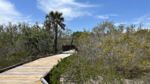
Protecting 120 acres along the northern reaches of Upper Sarasota Bay, Neal Preserve offers a unique perspective on archaeological research conducted in the 1930s.
Excavations by Federal crews with the Civilian Works Association, a project within President Franklin D. Roosevelt’s Works Progress Administration, led to significant finds.
 Burial mound at Neal Preserve
Detailed interpretive information reveals glimpses of a culture living along the shores of the bay during a flourishing period of cross-continental trade.
Trails and boardwalks wind between burial sites to two scenic viewpoints, an observation deck and a 20-foot observation tower with a panorama of the preserve.
 Observation tower
Resources




Disclosure: As authors and affiliates, we receive earnings when you buy through our links. This helps us provide public information on this website.
Overview
Location: Perico Island
Length: 0.5 mile loop
Trailhead: 27.495777, -82.685178
Address: 12301 Manatee Ave W, Bradenton
Fees: Free
Restroom: Portable toilet at trailhead
Land manager: Manatee County
Phone: 941-748-4501
Open sunrise to sunset. No pets or bikes. No removal of artifacts or plants. The trail system is largely in the sun. A picnic pavilion provides shade at the trailhead.
Directions
From US 41 (9th St SW) in downtown Bradenton, follow Manatee Ave (SR 64) west 7 miles, crossing over the causeways to the approach to the Anna Maria Island bridge. The preserve is on the left across from a large resort complex just before the bridge.
Hike
There are two entrances to the trail, the one leading straight ahead the most direct route to the tall observation tower.
For a more thorough introduction to the preserve and its significance, start on the other end of the trail system.
 Start of the hike
A boardwalk adjoins the “Neal Preserve Trail” sign at the end of the parking area. This accessible surface hovers above the salt flats of Perico Island.
Gaining railings when it crosses a murky marsh, the boardwalk passes under oak limbs bearded with Spanish moss.
 Entrance boardwalk
When the railings end, interpretive signage begins for native plants in the understory. One of the first surprises among them was upland cotton (Gossypium hirsuium).
We’d never seen it this far north in Florida. It was nearly wiped out by a misguided state policy to eradicate it.
They assumed it hosted boll weevils that destroyed farmer’s cotton crops. It did not. Now it’s an endangered species.
 Upland cotton
Curving through the coastal habitat, the boardwalk passes more identified plants before reaching a marker explaining the other purpose of the preserve.
It’s not just a haven for rare plants, but a significant cultural site, unfortunately disturbed. It had been replaced by a citrus grove when an archaeological dig took place in 1933-34.
Depression-era workers with the Civil Works Administration exhumed bodies from burial mounds on this site. Artifacts found date the site to 300 BC to 100 AD, the Woodland Period.
They were adjacent for part of that period to the Hopewell, who traded goods along the Gulf Coast far from their cultural centers north of the Ohio River.
 Sign denoting location of burial mound
Reach a T intersection in the boardwalk. A left turn returns to the trailhead, so make a right, walking through buttonwoods and mangroves.
Past a bench, turn right on a boardwalk with a railing. Eye-catching blooms of upland cotton adjoin the walkway, which proceeds beneath older black and white mangroves.
 Mangrove boardwalk
Gently curving, the boardwalk leads through a patch of shade provided by the mangroves and ends at 0.2 mile at an observation point on the open water of Anna Maria Sound.
Unfortunately, the adjacent coves were dense with dead seagrass on the surface, crusty and noxious, stinking during our visit.
 Emerging to Anna Maria Sound
Return along this boardwalk to the main trail boardwalk and turn right. Another interpretive sign calls out the location of a burial mound.
Topped with stones and shells and sparse vegetation, the mounded structure looks authentic. However, another source about this preserve calls it a re-creation.
Perhaps the bodies were reburied here. This marker and the first one denote the sites of the two burial mounds dug into in 1933.
 Burial mounds
The boardwalk ends. Continue on a shell path around the mound to a T intersection with a large interpretive sign about the culture that thrived between Tampa Bay and Sarasota Bay.
While most of their mounds (burial and temple) were leveled by modern settlements, a sprinkling of significant prehistoric structures remain nearby.
They are largely found edging the outflow of rivers and bayous into Tampa Bay, with Emerson Point containing the largest and tallest complex of mounds.
 T intersection
Turn right and read the second interpretive sign. It details the 1933 archaeological dig headed up by Dr. Marshall T. Newman with the blessing of the Smithsonian.
Sketches show the size and location of the burial mounds at that time. Excavations showed evidence of 227 burials in the larger shell mound, and 43 in the smaller sand mound.
Photos of some of the artifacts are displayed; the Bishop Museum in downtown Bradenton has representative pieces in their Tallant Collection gallery.
 Details about the 1933 dig
The observation tower looms just past this interpretive stop. It’s three full flights to the top, but the climb is worth it for the 360-degree views of Perico Island.
The streak of blue to the south and east is Anna Maria Sound, the drawbridge to Anna Maria Island clearly visible. It’s also easy to spot the clearings where the burial mounds were.
 View towards Anna Maria Island
Descend and continue past the trail junction and more interpretive plant identification as the shell path swings past Simpson’s stopper, gray nickerbean, and more wild cotton.
Emerging from the dappled shade of sea grapes and cabbage palms into the coastal flats, pass an osprey nest perched on a tall pole.
 Interpretation of native plants continues
The ospreys may be perched there as well; we spotted large chicks peeping over the edge in April.
Curving past a mud flat, pass the trail coming in from the other end of the boardwalk. Reach the trailhead next to the picnic pavilion after a half mile.
 Final straightaway
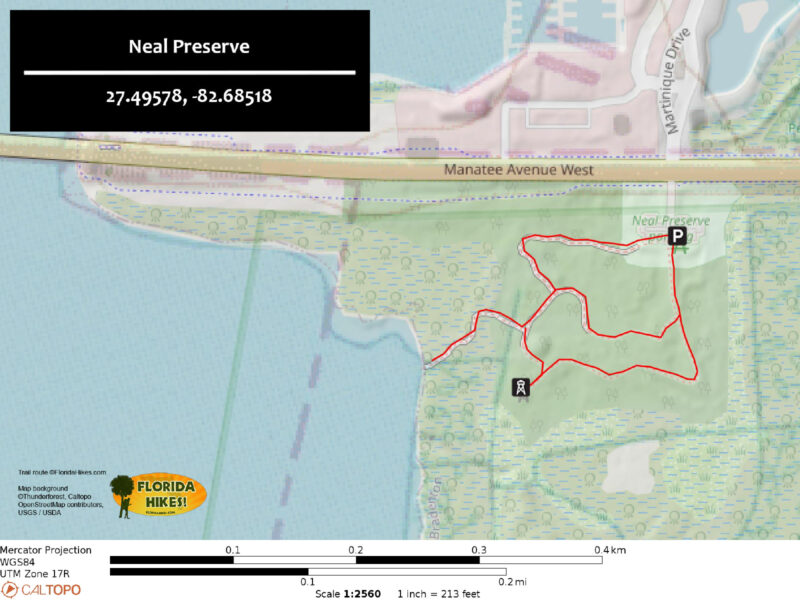
Trail Map
Explore More!
Video
A walk through Neal Preserve
Slideshow
See our photos from Neal Preserve
Nearby Adventures
 Leffis Key Preserve Discover the spectacular beauty of a coastal mangrove forest on a network of boardwalks along Sarasota Bay at the base of a 26-foot-hill with an outstanding view.
 Robinson Preserve Edging Tampa Bay, the vast sweep of Robinson Preserve is a puzzle of natural and restored habitats circled by more than ten miles of mixed-use trails.
 De Soto National Memorial Interpreting the landing of Spanish conquistador Hernando De Soto, De Soto National Memorial occupies a peninsula where the Manatee River flows into Tampa Bay.
 Emerson Point Preserve Where the Manatee River meets Tampa Bay, Emerson Point Preserve has a network of trails around a complex centered on one of Florida's most ancient temple mounds, the Portavant Mound, near Bradenton.

- Michael Crotty Bicentennial Park - November 3, 2026
- A.J. Henry Park - November 1, 2026
- Okeeheelee Nature Center Trails - October 22, 2026