
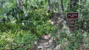
The Old Agrico Trail neatly complements the extreme mountain bike trails that Alafia River State Park is known for nationally.
The scenic hiking-only portion of the loop feels like a singletrack built for a crazy ride, along plummeting bluffs and water-filled pits.
 Atop a narrow ridge
One of Florida’s most challenging short hikes, it includes knife-edge walks atop narrow ridges and scrambles over rocks and roots, all in less than a mile.
The reason? Phosphate mining. Rich in phosphate, the Peace River basin is still the center of Florida’s mining industry.
Not until a couple of decades of mine diggings like these scarred the region was legislation passed that all mine sites must be reclaimed, the pits refilled and the landscape restored.
 One of the mine pits along the trail
This particular mine site was abandoned by Agrico (now Mosaic) before 1975, leaving a rugged, pockmarked landscape which reforested on its own.
Opened in 1998, Alafia River State Park put this roughed-up landscape to optimal use for cyclists and hikers.
 Drops and climbs are part of the fun
Resources





Disclosure: As authors and affiliates, we receive earnings when you buy through our links. This helps us provide public information on this website.
Overview
Location: Fort Lonesome
Length: 0.8 mile loop
Trailhead: 27.784484 -82.137254
Address: 14326 South CR 39, Lithia
Fees: $4-5 per vehicle
Restroom: At the trailhead
Land managers: Florida State Parks
Phone: 813-672-5320
Open 8 AM to sunset. Leashed dogs welcome.
With the exception of the shared Turtle Two-Track and Campground Connector, hikers may not walk the bike trails. Cyclists are not permitted on the narrow rugged portion of this trail.
Unlike the bike trails at this park, you can tackle this hike in either direction. The trail is very narrow so be courteous to other hikers passing by.
Directions
Service Road, Hillsborough County, Florida
From Interstate 75 exit 240 south of Riverview, follow SR 674 east to CR 39. Continue north to the park entrance.
Hike
From the day use parking area, follow the doubletrack trail used by all trail users past the playground, picnic area, and bike shop.
Entering the tree canopy, bear right and make a beeline for the large brown sign for the Old Agrico Trail.
 Start of the loop
Turn right, briefly sharing the entrance to the biking-only North Creek Trail to where the footpath diverges at a hiker symbol sign.
Edged by tall sword ferns, the path climbs a staircase to a ridge with a bench overlooking a double banked wooden curve on the North Creek Trail.
It’s hard to believe a cyclist can whip through that until you see one do it from this perspective.
 View of a skills area for cyclists
Past the bench the trail narrows atop the not-so-level ridge, with a view into a forested mine pit on the left.
Climb to the base of a large red-blazed oak, a dropoff into a water-filled pit with a glowing green surface beyond it.
 The trail quickly narrows after the oak
Walk a knife-edge between dropoffs to a rooty climb followed by a steep descent. The trail winds between oaks, hickories, and palms atop the ridge.
Drop closer to water level for the big green pond on the right, a far steeper dropoff on the left before the next rooty climb.
 Rooty climb
At the top of this one, an offshoot trail forks left, but the arrows on the post urge you straight ahead.
Descend from the scrabble of social trails hovering well above the main trail to an even better view of the green pond.
 Offshoot trail
Losing elevation quickly, mind the stairstep of roots as the footpath progresses to the bottom of this ridge.
Another arrow post makes sense of the confusion of worn trails up the walls of mine tailings left behind when Agrico moved on to mine other parts of Bone Valley.
 Pay attention to the many arrows in this section
Becoming a shaded, narrow track by a quarter mile, the footpath curves along the base of the mine tailing hill around a bed of ferns as if it were singletrack for cyclists.
At the Y junction, a helpful arrow guides you left and uphill, tree roots once again providing a natural staircase for careful climbers.
 Steep curve
The next Y junction also has a arrow pointing left, with a roller-coaster of footpath edging a fern-filled basin. Scramble over more roots to meet a briefly flat stretch of footpath.
Lantana sports yellow and orange flowers among a lush assemblage of seasonal bloomers.
 Root scramble
The hillside on the left is growing higher and steeper. Bear left again at the next junction, an arrow post confirming your route.
Limestone-loving spleenwort makes an appearance as the slope pitches more steeply, the footpath now outlined by logs on the right to forestall erosion.
 Climbing steeply
Round a curve and keep left again, continuing to climb. At a barren spot with protruding rocks, the crest of this steep hill towers overhead, dropping into the pit on the other side.
The footpath stays firmly at its base, descending along a fern-edged basin past red-blazed trees.
 Crest of old tailings pile adjoining the trail
Climb a rugged slope of rocks and roots up to higher ground as the basin broadens into a herbacious marsh.
At 0.4 mile, a side scramble leads to a big limestone boulder perched on its own promontory above the marsh.
 Perched boulder
The rooty natural staircase to it is even trickier to descend. Following a terrace above the marsh, pass an erosional feature in the high mine wall as the footpath ascends a ridge.
Drop quickly into a fern gully, with views of the glowing green mine pond that’s been hiding behind that slope all this time.
 Fern gully
Climb out of the gully and down to water level in a similar expanse of bright green on the right. Rounding this pond, continue upslope to circle it at a higher elevation.
Posts mark the edge of the dropoffs as the trail narrows again, climbing through a valley between mine tailing piles blanketed by forest and ferns.
 Mine pit at water level
Ignore a trail climbing away from the main path and stick to the curve, descending to a bridge over a small creek at a half mile.
Climb up and around the next slope, with roots again forming stairsteps to the crest. At the top is a set of trail signs.
 Bridge to the last steep climb
A right leads to the Campground Connector, which provides access to the hiking-only Alafia South Prong and Lonesome Lake Trails near the campground.
Turn left to loop back towards the trailhead. The pathway sweeps past a bench overlooking a mine pit and meets the Turtle Two Track.
 Decision point
Turn left at the T onto this sun-drenched doubletrack along the tree-lined edge of the meadow.
Pass an unmarked trail into the grassy expanse on the right, and a signposted access point with map soon after. It’s for cyclists to reach nearby singletrack loops.
 Joining the Turtle Two Track
Shifting into the shade, Turtle Two Track skirts past another pit-as-pond before bringing you back past the big sign for the Old Agrico Trail.
Continue through the day use area to the parking lot to wrap this unusual 0.8 mile hike.
 Finishing up the loop
Trail Map

Explore More!
Learn more about Alafia River State Park
 Alafia River State Park Alafia River State Park lets you launch on a Florida downhill while mountain biking the rugged terrain of a reforested open pit mine.
Video
Hiking the Old Agrico Trail
Slideshow
See our photos from the Old Agrico Trail
Nearby Adventures
 Fishhawk Creek Preserve South An easy-going 2.8-mile loop trail explores the south tract of Fishhawk Creek Preserve providing a glimpse of a few natural and endangered Florida habitats.
 Triple Creek Nature Preserve Tying together adjacent Triple Creek and Balm Boyette Scrub Preserve, this nearly 5-mile hike loops through restored upland habitats.
 Rhodine Scrub Nature Preserve An island of high ground in the Alafia River basin, Rhodine Scrub Nature Preserve protects more than 400 acres of Florida scrub habitat south of Riverview
 Alderman’s Ford Conservation Park Straddling the confluence of the North and South Prong of the Alafia River, Alderman's Ford Conservation Park provides immersion into lush riverine forests.

- Michael Crotty Bicentennial Park - November 3, 2026
- A.J. Henry Park - November 1, 2026
- Okeeheelee Nature Center Trails - October 22, 2026