• Skip to main content
  • Skip to header right navigation
  • Skip to after header navigation
  • Skip to site footer
Florida Hikes logo

Florida Hikes

Hike Bike Paddle Camp Florida with authors Sandra Friend and John Keatley as your guides

  • Trails
  • Maps
  • Guidebooks
  • Hike
    • Scenic Hikes
    • Loop Trails
    • Dog-friendly Hikes
    • Hikes for Kids
    • National Parks in Florida
    • Florida State Parks
  • Bike
    • Major Bike Trails
    • Paved Bike Trails
    • Off Road Biking
    • Biking Articles
  • Paddle
    • Canoe & Kayak Rentals
    • Paddling Destinations
    • Paddling Articles
  • Camp
    • Cabin Rentals
    • Car Camping
    • Primitive Camping
  • Florida Trail
    • Plan your Hike
    • Best Scenic Hikes
    • Best Backpacking
    • Section Hiking
    • Thru-Hiking
    • Trail Updates
  • Travel
Pine forest with low understory

Pine Log Crooked Creek Trail

A windy singletrack at Pine Log State Forest shared with off-road cyclists showcases pine savannas, tannic creeks, and a pitcher plant bog on this 4.5 mile hike.

Ebro (30.411167, -85.868556)   4.5 miles   Pine Log State Forest

On the eastern side of Pine Log State Forest, an impressive network of trails meander across vast sandhill and mesic flatwood habitats in the Choctawhatchee River floodplain.

Originally developed for bikes, the Crooked Creek Trail forms a 9-mile loop, crossing paths several times with the equestrian-only Old Sawmill Trail.

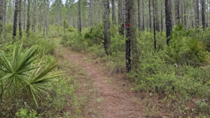
Sandy white singletrack amid pines The path is a narrow singletrack


The Crooked Creek Short Trail shortens the hike to 4.5 miles, creating an easier route for those on foot to explore these scenic landscapes.

Despite extensive logging over the years, the forest service has done an excellent job restoring and maintaining the natural beauty of this rural forest.

Person hiking amid pines in singletrack Restoration sandhill habitat


Resources

Resources for exploring the area
Hikers Guide to the Sunshine State book cover Florida Trail Hikes book cover The Florida Trail Guide book cover North Florida Panhandle Explorers Guide book cover Paddlers Guide Florida
 
Disclosure: As authors and affiliates, we receive earnings when you buy through our links. This helps us provide public information on this website.

Overview

Location: Ebro
Length: 4.5 miles
Trailhead: 30.411167, -85.868556
Address: SR 79, Ebro
Fees: $2 per person
Restrooms: Vault toilet at the trailhead
Land manager: Florida Forest Service
Phone: 850-535-2888

Open sunrise to sunset, leashed dogs welcome. Check ahead for hunting seasons. If you choose to hike during them, wear bright orange.


Directions


From the intersection of SR 79 and SR 20 in Ebro, head south on SR 79 for 2.3 miles. The trailhead parking area is on the left side of the road. The trailhead is 13 miles north of the intersection of US 98 and SR 79 in Panama City Beach.

Hike

At the trailhead kiosk, make an immediate left to begin the loop in a clockwise direction.

Red trail markers lead the way along a narrow strip of yellow sand cutting through a verdant sea of mixed foliage.

Picnic pavilion next to path Picnic tables at the trailhead


The trail follows a wide curve to the south, weaving between columns of slash pines in an open savanna.

It’s peppered with native milkweeds, meadowbeauties, greeneyes, and showy sandhill laurels, a diminutive cousin of the mountain laurel.

Pink flowers Sandhill laurels in bloom


Hilly terrain begins after passing a bench and a post marking one mile, where the trail approaches a ravine and tributary flowing north toward Little Crooked Creek.

Although water isn’t visible from the trail, the stream is evident from sloping landscapes and dense stands of hardwood trees.

Curving climb among pines and oaks Contoured topography


Turning to climb a sandy ridge, the path enters a clearing filled with woody goldenrod, an attractive shrub that produces plumes of vibrant yellow flowers in early autumn.

The trail then makes a tight bend around a steep depression before reaching a faint pathway leading down to a small stream.

Shrubs in a sandy clearing Woody goldenrod clearing


Tannic water rushes around a cluster of cypress knees, creating a tiny waterfall alongside a deteriorated bridge where the trail used to cross.

Shortly after reaching the two-mile mark, a sign indicates the blue trail used to shorten the hike.

Continue straight, following blue markers as the path veers westward.

Tiny cascade in narrow channel Creek waterfall


In a quarter mile, keep an eye out for a bog to the south marked with fuzzy white and yellow inflorescences of goldencrest.

Yellow-topped and parrot pitcher plants hide among the tall grasses.

Waxy yellow blossoms hover above beak-like leaves Parrot pitcher plants


Reaching a bench and intersection at 2.7 miles, join the red-blazed trail again. The path winds northward to follow alongside a floodplain swamp.

Thread between a mix of wet flatwoods and sandhill communities for 1.8 miles before returning to the trailhead.

Bench in woods behind red arrow sign Bench at the trail junction


Trail Map

Crooked Creek Trail Map


Explore More!

Learn more about Pine Log State Forest

Dogwoods arching over a frame of pines Pine Log State Forest Florida's oldest state forest offers waterfront camping and a variety of loop trails for hikers, cyclists, and equestrians, plus a 5.7 mile linear segment of the statewide Florida Trail.

Video

Hiking the Crooked Creek Trail


Nearby Adventures

Footbridge in a pine forest Faye and Dutch Trail Looping six miles through Florida’s oldest state forest, the Faye and Dutch Trail can be tackled as a day hike or a short backpacking trip.
Boardwalk through cypress swamp Pine Log Campground Trail Explore scenic wetlands and wildflower-filled pine savannas on an inviting 1.8 mile loop originating near the Sand Pond Campground at Pine Log State Forest.
Spring basin with aquamarine water Econfina Creek Nature Trail On the Econfina Creek Nature Trail, discover rugged climbs, steep drop-offs, bubbling springs, and deep crevices into the earth as you walk between two major springs where you can swim.
Orange blaze on crispy tree trunk amid longleaf pines Florida Trail, Choctawhatchee River 8.5 miles. Crossing majestic longleaf pine forests in Nokuse, the Florida Trail along the Choctawhatchee River floodplain showcases natural beauty from Cypress Creek to Seven Runs.

Trail Map (PDF) Hunt Dates Reserve Campsite Official Website

  • Author
  • Recent Posts
Chris Stevens
Chris Stevens
Along with his wife Chelsey, Chris Stevens shares outdoor adventures on Instagram and Facebook as @sunshinestateseekers and is a co-host of a podcast about Florida's outdoors, The Florida Madcaps. An avid hiker and camper, Chris serves as a Trailmaster and a board member for the Florida Trail Association.
Chris Stevens
Latest posts by Chris Stevens (see all)
  • Kelly Park - November 18, 2026
  • Wekiwa Springs Hiking Trail - November 17, 2026
  • Black Lake Preserve - November 15, 2026
Category: Biking, Day Hikes, Hikes, Loop Hikes, Northwest Florida, Off Road Biking, TrailsTag: Dog-friendly, Ebro, Florida State Forests, Hilly Trails, Panama City Beach, Pine Log State Forest, Pitcher Plants, Wildflowers

Sidebar

FarOut Guides

Our comprehensive trail logistics presented on offline maps:

Florida National Scenic Trail (1,500 miles)
Florida Keys Overseas Heritage Trail (108 miles)
Eastern Continental Trail in Florida (92 miles)


We earn a small commission on sales through these links. Thanks for your support!


Our Guidebooks

We’ve written guidebooks to Florida’s outdoors for over 25 years. These are our most recent.

Book cover with woman hiking through palms with baby carrier
Book cover of Florida Trail Hikes
The Florida Trail Guide fifth edition
50 Hikes in Central Florida 3rd edition

More Books

  • Facebook
  • Flickr
  • Instagram
  • Pinterest
  • Substack
  • Vimeo

Places to Explore

  • Trails
  • Parks
  • Beaches
  • Gardens
  • Springs
  • Ecotours
  • Attractions

FIND A TRAIL OR PARK

METROS: Bradenton. Clearwater. Crestview. Daytona Beach. Destin. Fort Lauderdale. Fort Myers. Fort Walton Beach. Gainesville. Jacksonville. Kissimmee. Lakeland. Melbourne. Miami. Naples. Ocala. Orlando. Panama City Beach. Pensacola. Port St. Lucie. Punta Gorda. St. Petersburg. Sanford. Sarasota. Sebring. Stuart. Tallahassee. Tampa. Vero Beach. West Palm Beach.

MULTI-REGION: Atlantic Coastal Ridge. Atlantic Coast. Bartram Trail. Big Bend. East Coast Greenway. Everglades National Park. Florida National Scenic Trail. Gulf Coast. Lake Wales Ridge. WATERWAYS: Indian River Lagoon. Intracoastal Waterway. Kissimmee River. St. Johns River. Withlacoochee River.

NORTHWEST FLORIDA: Altha. Apalachicola. Apalachicola National Forest. Big Bend Scenic Byway. Blackwater River State Forest. Blountstown. Bonifay. Bristol. Bruce. Cantonment. Cape San Blas. Carrabelle. Chattahoochee. Chipley. Crawfordville. DeFuniak Springs. Eastpoint. Ebro. Eglin Air Force Base. Freeport. Fountain. Gulf Breeze. Gulf Islands National Seashore. Holt. Madison. Marianna. Milton. Monticello. Mossy Head. Munson. Navarre. Navarre Beach. Newport. Niceville. Panacea. Panama City . Perdido Key. Ponce De Leon. Port St. Joe. Quincy. Santa Rosa Beach. Sopchoppy. South Walton. St. George Island. St. Marks. St. Marks NWR. Sumatra. Vernon. Wakulla. Wewahitchka. Woodville. WATERWAYS: Apalachicola River. Blackwater Bay. Blackwater River. Chipola River. Choctawhatchee Bay. Choctawhatchee River. Coastal Dune Lakes. Ochlockonee Bay. Perdido River. St. Marks River. Wacissa River. Wakulla River. Yellow River.

NORTH FLORIDA: Alachua. Amelia Island. Archer. Baldwin. Branford. Bronson. Bunnell. Callahan. Cedar Key. Chiefland. Crescent City. Cross City. Cross Creek. Dowling Park. Ellaville. Fanning Springs. Fernandina Beach. Flagler Beach. Fort White. Glen St. Mary. Green Cove Springs. Hawthorne. High Springs. Inglis. Jacksonville Beaches. Jacksonville Northshore. Jasper. Jennings. Keystone Heights. Lake Butler. Lake City. Live Oak.Macclenny. Mandarin. Mayo. Mayport. Micanopy. Middleburg. Old Town. Olustee. Orange Park. Osceola National Forest. Palatka. Palatka-Lake Butler Trail. Palm Coast. Palm Valley. Perry. Ponte Vedra. Rodman. Salt Springs. St. Augustine. Starke. Steinhatchee. Suwannee. Suwannee River Wilderness Trail. Suwannee Springs. Talbot Islands. Timucuan Preserve. Trenton. Waldo. Welaka. White Springs. Williston. Worthington Springs. Yankeetown. WATERWAYS: Santa Fe River. St. Marys River. Suwannee River. Tolomato River. Upper Withlacoochee River.

CENTRAL FLORIDA: Altamonte Springs. Apollo Beach. Apopka. Astatula. Astor. Auburndale. Bartow. Babson Park. Bayport. Belleview. Bithlo. Brandon. Brooksville. Bushnell. Canaveral National Seashore. Cassadaga. Christmas. Chuluota. Citrus Springs. Clearwater Beach. Clermont. Coast to Coast Trail. Cocoa. Cocoa Beach. Cross Florida Greenway. Crystal River. Dade City. De Leon Springs. DeBary. Deland. Deltona. Dunedin. Dunnellon. Edgewater. Enterprise. Eustis. Ferndale. Fort Meade. Frostproof. Geneva. Gibsonton. Haines City. Hernando. Hernando Beach. Holopaw. Homosassa. Inverness. Kenansville. Kissimmee. Lake Mary. Lake Wales. Largo. Leesburg. Lithia. Longwood. Lutz. Maitland. Malabar. McIntosh. Melbourne Beach. Merritt Island. Merritt Island NWR. Mims. Mount Dora. Narcoossee/Lake Nona. New Port Richey. New Smyrna Beach. Nobleton. Oak Hill. Oakland. Ocala National Forest. Ocklawaha. Ocoee. Oldsmar. Orange City. Ormond Beach. Osteen. Oviedo. Paisley. Palm Bay. Plant City. Poinciana. Polk City. Ponce Inlet. Port Orange. Ridge Manor. Riverview. Ruskin. Safety Harbor. Silver Springs. Sorrento. Spring Hill. St. Cloud. Tarpon Springs. Thonotosassa. Titusville . Umatilla. Viera. Walt Disney World. Weeki Wachee. Weirsdale. Wimauma. Windermere. Winter Garden. Winter Haven. Winter Park. Winter Springs. Withlacoochee State Forest. Withlacoochee State Trail. Yeehaw Junction. Zephyrhills. WATERWAYS: Alafia River. Halifax River. Hillsborough River. Lake Apopka. Little Manatee River. Ochlawaha River. Rainbow River. Tampa Bay. Wekiva River. Wekiva River Basin.

SOUTHWEST FLORIDA: Alva. Boca Grande. Cape Coral. Charlotte Harbor. Ding Darling NWR. Ellenton. Englewood. Estero. Immokalee. Marco Island. North Port. Osprey. Palma Sola. Palmetto. Pine Island. Port Charlotte. Sanibel Island. Venice. WATERWAYS: Caloosahatchee River. Manatee River. Myakka River. Pine Island Sound.

SOUTH FLORIDA: Arcadia. Basinger. Big Cypress National Preserve. Big Cypress Seminole Reservation. Big Cypress Swamp. Bowling Green. Clewiston. Everglades City. Indiantown. LaBelle. Lake Okeechobee Scenic Trail. Lake Placid. Lakeport. Moore Haven. Okeechobee. Ortona. Pahokee. Palmdale. Port Mayaca. South Bay. Wauchula. Zolfo Springs. WATERWAYS: Fisheating Creek. Lake Okeechobee. Peace River.

SOUTHEAST FLORIDA: Biscayne Bay. Biscayne National Park. Boca Raton. Boynton Beach. Coconut Creek. Coral Gables. Coral Springs. Davie. Delray Beach. Fellsmere. Flamingo. Fort Pierce. Hobe Sound. Hollywood. Homestead. Indrio. Jensen Beach. Juno Beach. Jupiter. Jupiter Farms. Key Biscayne. North Hutchison Island. Ocean to Lake Greenway. Palm Beach. Palm Beach Gardens. Pompano Beach. Redland. Sebastian. South Hutchinson Island. WATERWAYS: Florida Bay. St. Lucie River.

FLORIDA KEYS: Big Pine Key. Islamorada. Key Largo. Key West. Marathon. Overseas Heritage Trail.


©2006-2026, Sandra Friend & John Keatley | Disclosure | Site Index | Work with Us | Advertise with Us | Terms of Service and Privacy Policy

Florida Hikes PO Box 93 Mims FL 32754 | Contact