
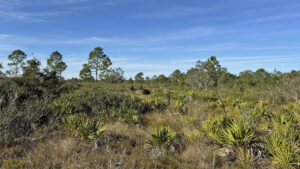
At the southern end of the Lake Wales Ridge, Platt Branch WEA presents a mosaic of unique habitats from oak and pine scrub to depression marshes and wet flatwoods.
Named after a stream to the north that drains into Fisheating Creek and eventually Lake Okeechobee, nearly 2,000 acres are protected.
 Walking through sandhills
On this vast public land are several endangered species including Florida scrub-jays and gopher tortoises.
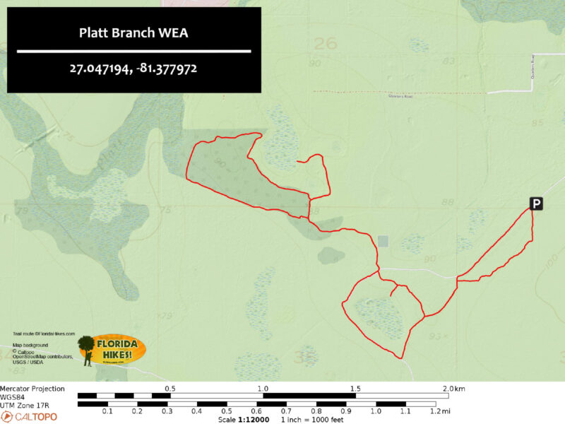
The trail system is well marked, consisting of three interconnected loops with two observation platforms overlooking grassy prairie ponds.
 Yellow blaze on an oak
Resources





Disclosure: As authors and affiliates, we receive earnings when you buy through our links. This helps us provide public information on this website.
Overview
Location: Venus
Length: 4.6 miles
Trailhead: 27.047194, -81.377972
Address: Detjens Dairy Rd, Venus
Fees: Free
Restrooms: None
Land manager: Florida Fish and Wildlife
Phone: 863-648-3200
Open a half hour before sunrise to a half hour after sunset. Leashed dogs welcome. Sun protection is recommended, as shade is very limited along the trails.
Directions
From the intersection of SR 70 and US 27 south of Lake Placid, head south on US 27 for 9.8 miles before turning right onto CR 731. In 1.3 miles, make a left onto Detjens Dairy Rd, and a right in 1.3 miles at the sign for Platt Branch WEA. Follow the dirt road for about 0.7 mile to a small parking area next to the trailhead.
Hike
Starting at the trailhead kiosk, pass through a stile next to a large metal gate and follow yellow blazes as they lead southward along a fence bordering wide grassy pastures.
The first trail marker at 0.1 mile is tricky to find, hidden behind a gap in clustered saw palmettos where the path takes a sharp right turn.
 Trailhead parking
A series of brown fiberglass posts indicate the trail as it weaves across a labyrinth of golden grasses and palmettos for a quarter mile.
Reach an access road paralleling a barbed wire fence. At a half mile, a sandy corridor cuts through densely packed scrub oaks and bushy lyonia.
Emerge at a trail junction within view of a wide depression marsh.
 Palmetto maze
The trail turns right onto a raised dirt road at 0.8 mile, following contoured terrain along the southern end of the pond as longleaf pines begin to dot the open savanna.
Raspy calls of scrub jays hidden in the underbrush blend with pleasant songs of eastern meadowlarks and short chirps of red bellied woodpeckers.
 Longleaf pine
Reaching an intersection of trails at 1.2 mile, turn left to follow a wide pathway of soft sugar sand westward as turkey oaks appear along the trail.
Indicative of dry sandhill and scrub communities, these eye-catching trees display a profusion of bright red and orange leaves before dropping their foliage in the winter.
 Turkey oak with fall colors
While circumnavigating the northwest loop, pass through scrubby flatwoods and the brief shade of a xeric hammock where a bench invites hikers to take respite from the sun.
As the trail crosses intermittent patches of stark white soils, fragrant Florida rosemary bushes border the path alongside sage tinted pinweeds and assorted lichens.
 Shaded bench
At 2.8 miles, a spur trail leads to an observation deck alongside an expansive depression marsh.
This side trip adds a little over a half mile to the hike, and it is worth venturing over for the view.
Reaching the end of the loop at 3.5 miles, follow the turkey oak path back to the middle loop and turn left to explore its northern half.
 Observation deck
Along the route, a short side spur leads to another overlook at a smaller, drier prairie pond.
Turning left where the middle loop concludes at 4.2 miles, follow yellow blazed posts on a slight ascent away from the depression marsh.
Reach an access road less than a quarter mile beyond it. The last leg of the hike follows a crushed shell road for 0.3 mile before returning to the trailhead.
 Trailhead in the distance
Trail Map
Explore More!
Video
Hiking Platt Branch WEA
Nearby Adventures
 Archbold Biological Station A pair of short loops provide close observations of rare scrub habitats at a historic research facility on the Lake Wales Ridge south of Lake Placid.
 Fisheating Creek WMA In the wilds of South Central Florida, Fisheating Creek has always been a favorite for paddlers. Four trails also provide access for hikers to enjoy these lush surroundings on foot.
 Florida Trail, Moore Haven to Lakeport Leaving the Caloosahatchee River to dip through the Fisheating Creek floodplain, this hike on the western side of Lake Okeechobee is all about the marshes.
 Gatorama Started in 1957 as a roadside attraction to show tourists one of the two Florida experiences they wanted - alligators! - Gatorama still has that funky Old Florida feel.

- Calusa Heritage Trail - November 5, 2026
- Scherer Thaxton Preserve - October 21, 2026
- Little Awesome Preserve - October 19, 2026