
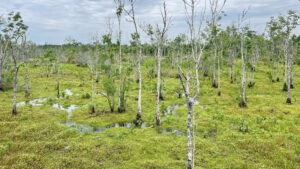
With 576 acres hugging the floodplain of the Ortega River, Ringhaver Park is an expansive city park with a large natural area beyond the expected ballfields and picnic pavilions.
A paved path, the Ortega Stream Valley Trail, winds into the forested edge of the floodplain, leading to a showy boardwalk across a hauntingly beautiful bog in the river basin.
 The boggy Ortega River floodplain
Resources





Disclosure: As authors and affiliates, we receive earnings when you buy through our links. This helps us provide public information on this website.
Overview
Location: Ortega
Length: 1.7 miles
Trailhead: 30.229327, -81.715687
Address: 5198 118th St, Jacksonville
Fees: Free
Restroom: Near the picnic area
Land Manager: City of Jacksonville
Phone: 904-255-7919
Open daylight hours. Leashed dogs welcome. This is an urban park, keep aware of your surroundings as you walk.
Directions
From Interstate 295 exit 10, Roosevelt Blvd (US 17), follow US 17 north 4 miles to Timuquana Rd (SR 134). Turn left at the light and follow Timuquana for 1 mile across the Ortega River Bridge. Turn left at Ortega Farms Rd. Follow this road south. Immediately after it makes a sharp right, look for the park entrance on the left. Drive all the way to the back of the park to find the trailhead, which adjoins a small picnic pavilion.
Hike
Find the asphalt path starting at the Ortega Stream Valley Trail sign near the tennis and pickleball courts.
The accessible path is self-evident but older wooden posts are marked with blue stripes denoting this as the Blue Trail.
 Trailhead
Skimming the edge of the forest, slip around the courts. A jug-handled natural side path diverges under the trees and rejoins. Another vanishes into the pines on the right.
The mix of trees suggests a mature sandhill habitat. Bracken fern rises from pine duff heavy in smilax vines; grapevines smother large patches of understory.
 Heading deeper into the woods
Entering a leafier hammock, scattered red maple and sweetgum are a reminder of your nearness to a river basin.
Towering pines herald the approach to a boardwalk at a quarter mile. Next to a built-in bench is a ramp to a footpath.
 Boardwalk with side trail
The path ascends to a secondary entrance to this trail from the small Morse Ave trailhead in an adjoining neighborhood.
The boardwalk hovers just off the forest floor, where cinnamon fern swarms around the base of a massive pine.
 Boardwalk in stream basin
Gaining railings, the boardwalk zigzags higher off the ground over the Ortega Stream floodplain, with another built-in bench before it ends.
Resume the asphalt path. A blue-ringed post calls attention to a trail junction; continue straight ahead.
 End of the boardwalk
The paved walkway curves away from a natural footpath into a long straightaway where a sandy path parallels and then veers off.
Mature bluestem palms adjoin the trail. They have the same profile as young saw palmetto but their deeper green fronds are relaxed and have no sawteeth along their stems.
 Bluestem palm
Beyond a bench, the understory opens up, revealing the property boundary with a pasture fated to become a subdivision.
Tangles of grapevine dangle from the limbs of sand live oaks. A bench sits in front of an ancient oak.
 Bench at the oak
At a half mile, an orange post at a beaten path marks the start of the Orange Trail, a natural surface loop of a half mile according to the park map.
We suggest you skip it. Its crossing point under the high tension lines wasn’t obvious, but a large urban encampment adjoining the powerline certainly was.
 Start of the Orange Trail
Following the curves of the asphalt path through the forest, pass another bench. Soon after, the habitat becomes more lush.
Bluestem palms and cabbage palms thrive under the oak canopy. The sandy path from the other side of the loop merges in.
An oversized sand live oak amongst younger ones calls attention to itself with thick splayed limbs.
 Outstretched limbs on a sand live oak
Past a curve, an asphalt path branches off to the right at 0.8 mile, leading to a boardwalk. Turn onto it for the walk to the Ortega River.
Emerging from treeline, marvel at the unusual habitat below the boardwalk. It’s unlike any other floodplain swamp we’ve traversed in Florida.
 Path to the boardwalk
Its lumpy surface looks similar to the muskeg bogs of the Great Lakes region, where spagnum moss provides a foothold for other vegetation.
From up on the boardwalk, it’s obvious you couldn’t walk or paddle across this habitat.
 Peering across the bog from the boardwalk
This high boardwalk extends a tenth of a mile, ending at a floating dock on the Ortega River.
It serves as a canoe launch and landing, but don’t be surprised to find folks fishing here, too.
 Ortega River
Return along the boardwalk to the trail junction, reaching it at 1.1 miles. Turn right. Past a blue-ringed post, the understory is far denser on this side of the loop.
A cross trail footpath merges in from the left. Mounds of grapevine resume under the oaks before the understory opens again.
 Footpath junction
A multi-trunked pine adjoins a footpath cutoff towards the boardwalk in the Ortega Stream basin. Complete the loop portion of the trail after 1.3 miles.
Turn right to exit via the boardwalks, retracing your walk out to the loop. Reaching the parking area, conclude a 1.7 mile hike.
 Almost back to the trailhead
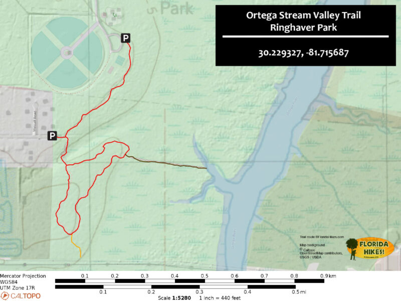
Trail Map
Explore More!
Video
Walking the Ortega Stream Valley Trail
Slideshow
See our photos from Ringhaver Park
Nearby Adventures
 Tillie K Fowler Island Trail On a hike of nearly 2 miles, the Island Trail at Tillie K. Fowler Regional Park shows off upland and floodplain forest habitats along the Ortega River in Jacksonville.
 Bulls Bay Preserve A natural waterfall splashes over an escarpment crowned with old growth trees along a series of loops shared by cyclists and hikers at Bulls Bay Preserve.
 Julington-Durbin Preserve Named for a pair of blackwater creeks that merge before entering the nearby St. Johns River, Julington-Durbin Preserve is a highly popular destination for exploring nature.
 Tommy Hazouri Sr. Mandarin Park A haven for wildlife under a canopy of mature hardwoods fronting Julington Creek, decades-old Mandarin Park was rededicated for a former mayor in 2023.

- Michael Crotty Bicentennial Park - November 3, 2026
- A.J. Henry Park - November 1, 2026
- Okeeheelee Nature Center Trails - October 22, 2026