
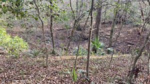
J.H. Anderson Jr Memorial Park encompasses 170 acres of Suwannee River floodplain and mature bluff forest.
The preserve trails were created by Alachua Conservation Trust, a regional nonprofit that manages the property.
 Trail beneath towering trees
Purchased by Suwannee River Water Management District to preserve Rock Bluff Spring and its upland recharge, the landscape is studded with karst features.
Picnic tables overlook the small second-magnitude spring, which attracts boaters and swimmers up its short run.
 Rock Bluff Spring in winter
Resources





Disclosure: As authors and affiliates, we receive earnings when you buy through our links. This helps us provide public information on this website.
Overview
Location: Bell
Length: 1.5 miles
Trailhead: 29.799661, -82.918828
Address: 6560 CR 340, Bell
Fees: $4 per vehicle
Restroom: At the trailhead
Land Manager: Alachua Conservation Trust
Phone: 352-373-1078
Open 8 AM to 7 PM. Leashed dogs welcome on the trail but not in the spring. No alcohol, ATVs, or golf carts.
Directions
From Chiefland, follow US 19/98 north to Fanning Springs. Turn onto SR 26 north. Follow it for 2.4 miles. Make a left on CR 341 and continue north 13 miles. At the stop sign at CR 340, turn left. Drive 0.2 mile, making a right into the preserve just before the bridge over the Suwannee River. After stopping to pay the fee at the drop box, follow the narrow, rough unpaved entrance road for 0.2 mile to the parking area.
Hike
From the trailhead at the spring, aim for the gap in the fence where the kiosk marks the start of the trail system.
It’s well marked, but a map is displayed and brochures are available. The first of the loops is the green blazed Magnolia Trail.
 Trailhead kiosk
Start by turning right and bearing right at the Loop Trail sign. Veer up a slight rise into the bluff forest past an enormous loblolly pine.
Winding beneath the oak canopy, slip past a cluster of younger magnolias.
 Start of the Magnolia Trail
Broken trees and a large amount of deadfall attest to the power of Hurricane Helene grazing this region in 2024.
Walk by clusters of bluestem palm between columns of tall oaks that survived the storm.
 Follow the green markers
Beyond an archway of oaks, wriggle deeper into the bluff forest. Ancient magnolias tower overhead.
Dahoon holly sports its bright red berries in winter. The understory opens up briefly before the forest closes in again.
 Holly and magnolia trees
At a quarter mile, meet the junction for the Connector Trail. Make a right to follow it, red diamond blazes leading the way.
Beyond a tight corridor of trees, round the bulging base of a large oak. Arrive at a Loop Trail sign. The forest floor drops off beyond it into a large sinkhole.
 Trail junction
Turn right to start the Sinkhole Trail, circling around this first big depression. It’s one in a chain of sinks above the underground stream feeding Rock Bluff Spring.
Loop into a denser bluff forest along blue diamond blazes. A half mile into the hike, ancient oaks form a high canopy.
 Among the oaks
The bluff becomes obvious where the footpath skims its edge, the landscape dropping into a large depression swamp.
Cypress knees jut from its bottom; the white line at its far side is the entrance road. Depending on recent river levels, a flood shadow may stain the trees inside it.
 Cypress swamp
Walk beneath the tall oaks on the bluff, reaching a marker for a sharp turn at 0.7 mile. Burrow more deeply into the bluff forest.
Rambling between clusters of bluestem palm, loop around a sharp curve.
 Passing a karst depression
Begin a winding route around depressions in the forest floor. Surrounded by tall trees, these sinkholes come in a variety of sizes and depths.
At 1.1 miles, complete the Sinkhole Trail loop at the Connector Trail and Exit sign.
 Leaving the Sinkhole Trail
Follow the Connector Trail back to the Magnolia Trail. Turn right. Around the next curve is a small fern-edged sinkhole at the base of a tree.
Round a long crevice in the forest floor before the footpath turns away from it, rising to higher ground.
 Fern-rimmed sinkhole
Largely magnolias and oaks on this bluff, it’s a little rooty underfoot as the trail winds through the forest. Tripping hazard roots are painted orange.
A line of sky through the winter landscape reveals the nearness of the Suwannee River on the ascent.
 Nearing the river basin
Drop towards the parking area at the spring, completing the Magnolia Trail.
Reaching the gap in the fence at the kiosk, wrap up this 1.5 mile hike with a walk to the spring.
 Exiting the trail
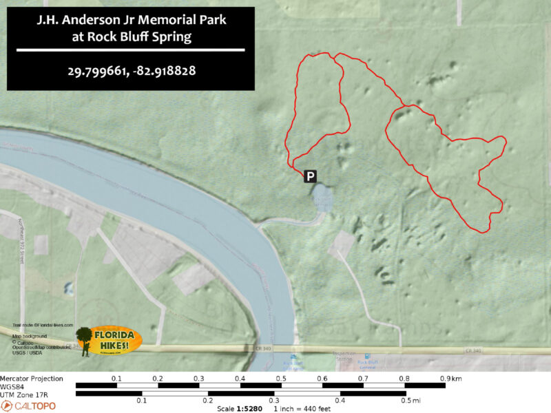
Trail Map
Explore More!
Video
Hiking J.H. Anderson Memorial Park at Rock Bluff Spring
Slideshow
See our photos from this hike
Nearby Adventures
 Hart Springs Park Cool, clear water bubbles up from deep below where a boardwalk offers views of the Suwannee River and 3.2 miles of hiking trails cross a floodplain forest dotted with sinkholes.
 Otter Springs At an inviting second magnitude spring, a shaded nature trail traces the spring run as it flows towards picturesque views on the Lower Suwannee River.
 Fanning Springs State Park One of the Suwannee River's largest swimming holes is the clear, cool reflecting pool of Fanning Springs, located along the edge of its namesake town.
 Ichetucknee Springs State Park A swimming hole as a work of natural art, the deep gash in the earth that is Ichetucknee Spring glows an unearthly robin's-egg blue, cradled in a limestone bowl within a leafy glen.

- Michael Crotty Bicentennial Park - November 3, 2026
- A.J. Henry Park - November 1, 2026
- Okeeheelee Nature Center Trails - October 22, 2026