
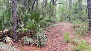
Surrounding the floodplain of Seaton Creek, this 840 acre preserve is a battlefield, literally and metaphorically.
Victim to timber companies supplanting Florida’s natural habitats with fast-growing commercial pine crops, it has rows and rows of pines at its core.
Natural habitats have made their incursions, winning over this commercialized forest in its dampest and driest corners.
Within the preserve, Seaton Creek and Houston Creek rise from bayheads and floodplain forests, flowing north into Thomas Creek.
 Waterway flowing to Houston Creek
In 1777, the southernmost battle of the American Revolution also took place in this vicinity. Northeast Florida was under British rule at the time.
With British Loyalists making raids into Georgia, the Georgia militia struck back. Ambushed by British forces, only a quarter of the troops survived the Battle of Thomas Creek.
It was the first time American forces tried to take Florida from the British. Two subsequent tries also failed.
Florida remained under British and then Spanish rule until 1821, when it became a United States territory in exchange for payment of Spanish debts.
 Historic marker at trailhead
Two separate entrances flank a relatively new subdivision under one of the flight paths of Jacksonville International Airport.
The eastern entrance has a forest road leading to a landing and picnic area on Bear Swamp Creek. West of the subdivision, the main entrance leads to a substantial trail system.
Extending towards Thomas Creek, a chain of three loops combines footpath with a backbone of a forest road.
The loops south of Houston Creek have cross-trails, enabling you to tailor the length of your hike. North of the creek, is the 1.7 mile Legacy Loop, which has a landing on Houston Creek.
 Trail junctions are marked
The voraciousness of the yellowflies and mosquitoes in this basin in early May was unlike any other insect swarms we’ve encountered in Florida.
Our intent had been to tag-team the full trail system, but we had to beat a retreat from the Houston Creek bridge.
Since pine plantations dominate the remainder of this multi-use trail system, we feel our 4.2 mile route covers the best hiking in this preserve.
 Oak hammock along the edge of a pine plantation
Resources





Disclosure: As authors and affiliates, we receive earnings when you buy through our links. This helps us provide public information on this website.
Overview
Location: Jacksonville
Length: 4.2 miles
Trailhead: 30.521551, -81.669140
Address: 2145 Arnold Rd, Jacksonville
Fees: Free
Restroom: None
Land manager: City of Jacksonville
Phone: 904-255-7919
Open sunrise to sundown. Leashed pets welcome. Cyclists and equestrians share the trails. Insect repellent is a must.
Directions
From Interstate 95 north of Interstate 295 in Jacksonville, go one exit north of Jacksonville International Airport to exit 366, Pecan Park Rd. Drive west 1.6 miles and continue straight on Arnold Rd. Continue a half mile to the trailhead entrance on the right, just past the subdivision.
Hike
From the trailhead corral, head for the historic marker and kiosk. A large map gives an overview of the trail system.
Beyond it, begin the first loop by veering off the broad grassy Main Trail to the narrower Houston Creek Trail.
 Trailhead kiosk
In a corridor flanked by loblolly pine, sprays of hatpins dance inches off the forest floor. Cinnamon ferns peep from the shade of wax myrtle and spills of grapevine.
While often close enough to the property boundary that the subdivision is obvious through the pines, it’s a pleasant walk.
 Houston Creek Trail
After a quarter mile, a sharp left turn into a tunnel of sweetgum meets a T with the Main Trail. Turn right.
More obviously a forest road at this point thanks to the worn two-track, it straddles a boundary between planted pines and floodplain forest.
 Joining the Main Trail
Fencing on both sides of a mild rise defines a not-so-obvious bridge. Peer through the gaps in the fence to see the sluggish waterway flow through a ditch engulfed by forest.
At a half mile, veer left at the trail junction with a bench to stay on the Houston Creek Trail. This is the bottom of the loop that stays south of Houston Creek.
 Veer left at the bench
Ascend into relict sandhill attempting to reclaim the pine plantation. Crowded into a tight corridor of vegetation, the pathway narrows.
Continue past a linear cross trail to the Main Trail at a marker topped with a yellow arrow.
 Trail crossing
Enter a more relaxed habitat of pine flatwoods with large clumps of saw palmetto and oaks. Lines of planted pines are still visible beyond them.
An extreme narrowing of the corridor happens past an worn path to the right at 0.7 mile, a half-hidden yellow marker pointing forward.
 The trail corridor narrows
Walls of shiny lyonia and young oaks rise over head height, becoming less of a visual block at a transition into pine plantation.
Weaving between rows of pines, come to a straightaway where the commercial orgin of this pine forest can’t be denied.
We hope the plan is to restore this to a natural habitat. Sweetgum and red maple eventually invades the eastern flank of the stark rows of pines.
 Straightaway into a row of planted pines
Reach an important decision point for the loop at 0.9 mile at a T intersection with the 0.4 mile Long Cut.
It connects to the blue-blazed Main Trail for a 2.9 mile loop to the trailhead.
As the name “Long Cut” implies, it is not a shortcut to Houston Creek. To stay on the outer loop, make a left to continue along the Houston Creek Trail.
 Long Cut junction
Enter a hardwood forest, winding between patches of grass under a variety of mature oaks.
Cross a muddy, sometimes wet drainage where past visitors have added logs for crossing. As the canopy thins, the forest starts to edge the Houston Creek basin.
 Grassy forest floor in hardwood hammock
Reach a picnic table in a clearing. Although the creek is not visible, it is nearby. At 1.7 miles, emerge at an intersection with the Main Trail.
There is a bench in a clearing amid planted pines. This is the upper end of the Houston Creek Trail.
 Picnic table
The bridge over Houston Creek lies north, with the 1.7 mile Legacy Loop beyond it. Clockwise, that loop circles a vast center of pine plantation.
Less than a half mile of that loop follows the hardwood forests above mazy, estuarine Thomas Creek. Battling insects, we opted to skip it.
To the right, the Main Trail makes for the quickest return to the trailhead. However, it’s largely surrounded by pine plantation.
Rows of pines are boring to hike through but the Main Trail is easier to bike.
Hikers should continue straight ahead past the bench to begin the far end of the Long Cut.
 Bench at Houston Creek and Long Cut upper junction with Main Trail
After a nice walk through the strip of hardwood forest bordering Houston Creek, it curves south. The remainder of its loop back to the Main Trail is in pine plantation.
Reach that junction at 2.3 miles and jog slightly south to stay on Long Cut.
It becomes the most immersive part of this hike, surrounded by the leafy greens of floodplain trees.
 Long Cut west of the second Main Trail junction
Pines were planted among them, but sweetgum and loblolly bay assert their presence in this damp habitat.
Drop through a small drainage and ascend to higher ground, an oak hammock gaining ground against the pines.
Narrowing, the path is walled off by the dense understory. As red maples and sweetgum increase, enter the floodplain.
 Dry drainage across Long Cut
Cross a mucky drainage where sweetgum saplings thrive. Against the light green leaves of the forest, the dark greens of a Southern magnolia stands out.
While the floodplain forest hasn’t won this battle, it’s taken a strong stand against the straight-line poles of the pine trunks.
Several types of ferns emerge from the damp earth, including netted chain fern.
Looking like a relaxed version of saw palmetto, bluestem palm has fronds brushing the leaf-strewn path.
 Floodplain and pines meet
Ascend from the floodplain to slightly higher ground, the woodlands retaining a pleasant mosaic of leaf shapes.
Reaching the initial junction of Long Cut and the Houston Creek Trail at 3.2 miles, complete the middle loop.
Turn left to retrace the Houston Creek Trail south through its pine plantation and natural habitats, merging onto the Main Trail at 3.6 miles.
Continue straight south along this broad grassy forest road, crossing the bridge.
 To the west, the trail is bordered by a floodplain
To tackle the western side of the southernmost loop, pass by the turnoff for the Houston Creek Trail at 3.9 miles. At this end of the Main Trail, the forest crowds in more closely.
Another line of fencing defines a depression bridged by the road. Curving through the woods beyond it, finish along a grassy straightaway.
Reach the trailhead corral at 4.2 miles to complete this hike.
 Final bridge along the Main Trail
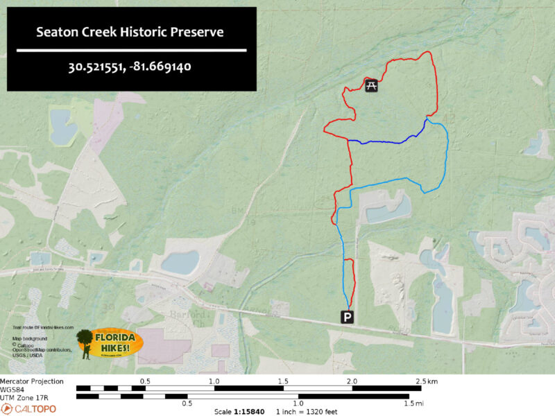
Trail Map
Explore More!
Video
A walk through Seaton Creek Historic Preserve
Slideshow
See our photos from Seaton Creek Historic Preserve
Nearby Adventures
 Maple Set Trail Providing a peek into an ecologically important area along the eastern edge of Bethea State Forest, the 2.5 mile Maple Set Trail showcases the beauty of the St. Marys River basin.
 Bulls Bay Preserve A natural waterfall splashes over an escarpment crowned with old growth trees along a series of loops shared by cyclists and hikers at Bulls Bay Preserve.
 Simmons State Forest With more than 3600 acres along the St. Marys River, Simmons State Forest offers nearly 12 miles of hiking in a botanically significant basin on Florida's border with Georgia.
 Bogey Creek Preserve A well-interpreted and easy loop hike honors the legacy of a Jacksonville author who left her waterfront homestead for future generations to enjoy.

- Hal Scott Yellow Trail - November 3, 2026
- Hal Scott Preserve - October 28, 2026
- Tradewinds Park - October 27, 2026