
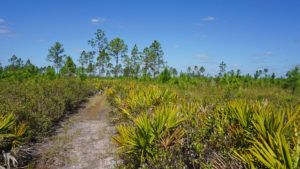
Traversed by a segment of the statewide Florida National Scenic Trail and bounded to the east by the Wekiva River floodplain, Seminole State Forest offers expansive wild landscapes along the edge of the Orlando metro.
Protecting nearly 29,000 acres, the forest is a keystone in a greenbelt connecting the Wekiva River basin and the Ocala National Forest, providing critical wildlife habitat in an area increasingly hemmed in by growth.
 A broad open prairie at the heart of Seminole State Forest
Resources





Disclosure: As authors and affiliates, we receive earnings when you buy through our links. This helps us provide public information on this website.
Overview
Location: Sorrento and Cassia
Headquarters: Lake Forestry Station, 9610 CR 44, Leesburg
Primary Trailhead: 28.81965, -81.4285
Fees: $3 per person day use fee at trailheads
Restrooms: Vault toilets at trailheads
Land manager: Florida Forestry Service
Phone: 352-360-6675 or 352-360-6677
Leashed dogs welcome. Insect repellent a must. Bicycles welcome on forest roads but not on hiking trails. Several primitive campsites are available. Sites must be reserved in advance.
Bears are frequently encountered in this forest. Backpackers must protect their food. Bear bag or bring a bear canister.
Seasonal hunting occurs throughout this the forest, but hunting seasons are limited. Check ahead before you make plans for outdoor recreation.
The forest is laced with a network of rough forest roads, which are normally only open to drivers during hunts.
Directions
While there are multiple walk-in access points to this forest from roads and adjacent public lands, two main trailheads provide parking. At both, pay the day use fee ($3 per person) and sign the register before you leave your car. The southermost trailhead is Bear Pond, east of Sorrento. From Interstate 4 in Sanford, take exit 101C and head west along SR 46 for 5.2 miles. The turnoff for the trailhead is on the right just after the highway crosses the Wekiva River. The trailhead itself is a mile down the entrance road. For the Cassia trailhead, continue west on SR 46 to the turnoff for SR 46A. Follow SR 46A to SR 42. Turn right and continue towards DeLand. The Cassia trailhead is off Brantley Branch Road, on the right side of the highway at the Camp Boggy Creek sign.
About the Forest
Wildlife sightings are always an integral part of any visit to Seminole State Forest, particularly because of its legendary Florida black bear population.
On our hikes, we’ve seen full-grown bears, juveniles, and mothers with cubs. Unless they’re in a tree, most move fast to get out of your way.
 Paw print of Florida black bear in the sand
Both day hikers and backpackers should be alert for bears–sign, tracks, and the bears themselves–particularly when bringing food along.
Otters frequent Black Water Creek and its tributaries, and white-tailed deer are common along the footpaths.
 Backpacking Seminole State Forest
One rare delight is a well-established colony of Florida scrub-jays in the scrub forests that start just a mile north of the southern trailhead.
Wildflowers bloom in abundance in fall and spring, particularly across the open prairies at the heart of the forest. And although only one is visible along a trail, there are dozens of bubbling springs.
 Blazing star blooming in a prairie
Hiking
Four named hiking trails offer different ways to experience the broad variety of habitats at Seminole State Forest. These include a portion of the statewide Florida Trail as well as three named loops.
Two of these loops — Lower Wekiva and Sulphur Island — branch off of and utilize a portion of the Florida Trail as a part of their route. Both are part of the Trailwalker Hiking Program.
 Lower Wekiva Loop Venture across lush floodplain forests of Blackwater Creek and the Wekiva River, using a scrubby section of the Florida Trail to create the 10.5-mile Lower Wekiva Loop.
 Sulphur Island Loop A short distance from the bustling metropolis of Orlando, the Sulphur Island Loop Trail explores one of Florida’s endangered ecosystems, the scrub.
The third loop is just a little over a mile long and provides an easy and level interpretive hike around Bear Pond at that trailhead.
In addition, many of the forest roads can be tied into the Florida Trail and the loop trails to provide loops of a variety of lengths.
 Mileage sign on the Florida Trail
Florida Trail
A 10.3-mile linear segment of the Florida Trail crosses the forest south to north between SR 46 and SR 42 and can be accessed via the two trailheads.
This segment includes three primitive campsites — one with a trail shelter — along its route, which offers botanical and habitat diversity as well as extensive panoramas across open pine savannas.
 Florida Trail route through a floodplain basin
North of SR 42, the Florida Trail continues north-northwest for another 7.2 miles through what’s termed the Cassia section, now protected by this state forest.
It slips into Camp La-No-Che, a Boy Scouts of America high adventure camp, at its northern end, en route to the Ocala National Forest.
 Florida Trail, Seminole State Forest 7.5 miles. Walk through vast, open spaces that you’d never imagine existed so close to Orlando.
 Florida Trail, Cassia 14.2 miles. Traversing miles of endangered desert-like scrub habitat through Seminole State Forest, the Cassia section of the Florida Trail offers unique natural observations amongst sparse shade.
Equestrian Trails
Shown in brown on the State Forest map, a 25-mile network of equestrian trails offers miles to roam on horseback.
This network includes three loops — River Creek (7.2 miles), Paola (4.2 miles), and Sulphur Island (7.4 miles) — which are also open to hikers.
 One of many roads open to equestrians
Biking
Biking is permitted on the network of more than 25 miles of forest roads within the state forest. Access these roads from either trailhead.
We’ve utilized the dirt road network to make a round-trip of nearly 30 miles between Bear Pond and the edge of the town of Paisley.
 Deer jumping in front of cyclist
Camping
Primitive campsites are available for backpackers along the Florida Trail and the Lower Wekiva Loop, built and maintained by the Florida Trail Association.
Shelter Camp, home to one of the rare Florida Trail shelters (originally constructed in 1992 and rebuilt since) is an easy destination for families easing their children into backpacking.
Several group campsites are also available by reservation.
 Shelter Camp
While Fern Camp offers a great deal of privacy along the Lower Wekiva Loop, Blackwater Creek Camp is perched along a tannic waterway flowing towards the Wekiva River.
Horsepackers and cyclists make use of Sulphur Camp, which sits at an intersection of trails within walking distance of picturesque Shark Tooth Spring.
 Sulphur Camp is large enough for a group
Paddling
Paddlers are permitted to hand-launch into Black Water Creek whenever Sand Road is open to access the launch point north of the bridge. A picnic table marks the spot.
Flowing out of Lake Norris into Seminole State Forest, the creek is not generally navigable from the launch to its north end.
South of the launch, it is broader, passing through floodplain forest as it heads to the Wekiva River.
 Put-in along Black Water Creek
Other Activities
Birding
Seminole State Forest is known for its Florida scrub-jay population. These rare endemic Florida birds can be seen in family groups in scrub habitat a little over a mile north of the Bear Pond trailhead.
Sandhill cranes congregate in the open savannas south of Black Water Creek and the prairies adjoining ponds just a couple miles south of the Cassia trailhead.
 A pair of sandhill cranes
Fishing
A fishing pier is provided at Bear Pond, adjoining the parking area. Anglers are also welcome to cast in Black Water Creek.
 Accessible fishing pier on Bear Pond
Hunting
Seasonal hunting is permitted in Seminole State Forest in accordance with FWC regulations for fall deer season and spring turkey season.
Most hunts in this forest are of limited duration during those periods. Please consult the FWC Hunt Dates link below for a map of permitted hunting zones and exact dates of upcoming hunts.
 Seasonal hunt check station north of Bear Pond
Picnicking
A large picnic pavilion can be rented at Bear Pond trailhead for family gatherings and other special events. A grill is on site.
 Pavilion at Bear Pond trailhead
Trail Map

Explore More!
Related Articles
 Billy Goat’s Birthday In what has become an annual event along the Florida Trail, hikers gathered in January to celebrate the birthday of Billy Goat, a long-time member of the long distance hiking community.
 Couples and Backpacking There are many pluses to backpacking as a couple. Having a compatible partner smooths out a lot of logistical worries and reduces the weight you need to carry.
 Seminole, for bear One of my most recent delights, on a walk in the woods, was the surprise provided by Seminole State Forest on a revisit after a decade: a bear encounter.
Slideshow
See our photos from Seminole State Forest
Nearby Adventures
 Rock Springs Run Reserve State Park You have a better-than-average chance of spotting a Florida black bear at Rock Springs Run State Reserve, a vast wilderness area in the Wekiva River basin.
 Lake Lucie Conservation Area A shaded loop trail winding through mesic hammocks borders a marsh that was once known as Lake Lucie.
 Black Bear Wilderness Area North of Orlando, Black Bear Wilderness Area in Sanford offers some of the best wildlife watching in the region on its loop along the St. Johns River.
 Lower Wekiva River Preserve State Park Paddle, hike, or ride your horse within this massive riverine preserve on the edge of the Orlando metro, where the Wekiva River and St. Johns River mingle.

- Hal Scott Yellow Trail - November 3, 2026
- Hal Scott Preserve - October 28, 2026
- Tradewinds Park - October 27, 2026