• Skip to main content
  • Skip to header right navigation
  • Skip to after header navigation
  • Skip to site footer
Florida Hikes logo

Florida Hikes

Hike Bike Paddle Camp Florida with authors Sandra Friend and John Keatley as your guides

  • Trails
  • Maps
  • Guidebooks
  • Hike
    • Scenic Hikes
    • Loop Trails
    • Dog-friendly Hikes
    • Hikes for Kids
    • National Parks in Florida
    • Florida State Parks
  • Bike
    • Major Bike Trails
    • Paved Bike Trails
    • Off Road Biking
    • Biking Articles
  • Paddle
    • Canoe & Kayak Rentals
    • Paddling Destinations
    • Paddling Articles
  • Camp
    • Cabin Rentals
    • Car Camping
    • Primitive Camping
  • Florida Trail
    • Plan your Hike
    • Best Scenic Hikes
    • Best Backpacking
    • Section Hiking
    • Thru-Hiking
    • Trail Updates
  • Travel
Mud flats edged by mangroves

Snake Bight / Rowdy Bend

The Snake Bight Trail in Everglades National Park leads you a wild place where tropical forests meet the mangrove shorelines of Florida Bay, where crocodiles cruise the saline shallows and mosquitoes thicken the air.

Flamingo (25.1999, -80.8745)   7.6 miles   Everglades National Park

It’s a wild corner of Florida, where tropical forests meet the mangrove shorelines of Florida Bay, where crocodiles cruise the saline shallows and mosquitoes thicken the air.

It’s getting even wilder these days, with the unfortunate proliferation of exotic species like pythons and anacondas.

Snake Bight has always been an outpost on the edge, a place where flamingos from Cuba and the Yucatan gather each December, scooping through mud flats to feed along the shores of Everglades National Park.

This is a multi-use trail (shared with bicycles) with several options. You can take a round-trip walk out to Snake Bight, use two cars to walk 4.9 miles between the two trailheads, or do a full loop by returning along the Main Park Road.

Snake Bight / Rowdy Bend


Resources

Resources for exploring the area
50 Hikes in South Florida book coverSouth Florida Explorers Guide book coverHikers Guide to the Sunshine State book coverPaddlers Guide Florida The Hiking Trails of Floridas National Forests Parks Preserves book cover
 
Disclosure: As authors and affiliates, we receive earnings when you buy these through our links. This helps us provide public information on this website.

Overview

Location: Everglades National Park
Length: 7.6 mile loop or 3.5 mile round-trip
Trailhead: 25.1999, -80.8745
Fees: Everglades National Park entrance fee
Restroom: No
Land Manager: National Park Service

This trail has the worst mosquitoes in the park. You’ve been warned.


Directions


From the Everglades National Park visitor center in Flamingo, drive 5.4 miles north on the Main Park Road to the pull off for Snake Bight, on the right. If you’re leaving a car at the Rowdy Bend trailhead, it’s 2.7 miles north of Flamingo on the right; park on the grass just after the “Rowdy Bend Road” sign.

Hike

Start at the Snake Bight trailhead to walk through the tropical forest on a straight-and-narrow path paralleling the Snake Bight canal.

It was once a road leading to the long-defunct E.C. Knight Fish Company processing plant, but it’s hard to imagine this ever being a road. The forest closes in so tightly you feel like you’re on an adventure, and you are.

Alligators cruise the canal. Yellow nickerbean cascades from mahogany trees. You pass a land bridge that leads to the old Crocodile Point trail system.

It’s no longer open due to the dense growth of poisonous manchineel trees through the forest. Better you stay to the beaten path.

The tropical forest yields to a coastal prairie of buttonwoods and salt hay, where the air is filled with the salt tang that marks the Everglades coast and the footpath is a soft blanket underfoot.

That doesn’t last long as you get into the marl, the squishy goo leading to the boardwalk at the edge of the bight.

The trail ends after 2 miles at observation platform with a sweeping view of Snake Bight, a shallow inlet off Florida Bay.

Mud flats edged by mangroves
Snake Bight, along Florida Bay

Scan the horizon for the slim figures of flamingos on the mud flats, and consider yourself fortunate if you see them. The flock has diminished greatly in the past century, from hundreds to only dozens returning each winter.

Turn around and backtrack 0.3 mile to the sole unmarked opening on the left that leads you to the Rowdy Bend Trail. This is your decision point for doing the full loop, or returning along the Snake Bight Trail to your car.

Starting out as a broad grassy path, the Rowdy Bend Trail narrows as you wind through coastal prairie and tropical hammock.

Bromeliads cling to the buttonwoods. After 2.8 miles, enter a dark tropical forest before the footpath emerges onto a vast open prairie with water holes.

The footpath becomes cement-like marl, changing to a soft carpet of salt hay as the trail becomes a deep rut in the grass.

The corridor eventually tightens and the footpath is full of roots as you walk beneath cabbage palms, mahogany, and blolly. Watch your footing. At 4.8 miles, the trail emerges on the Main Park Road.

If you don’t have a second vehicle stashed here, turn right and walk along the edge of the mangrove-lined paved road (be alert for vehicles) for 2.7 miles.

Pass Coot Bay Pond and Mrazek Pond en route to the end of the loop at the Snake Bight trailhead.
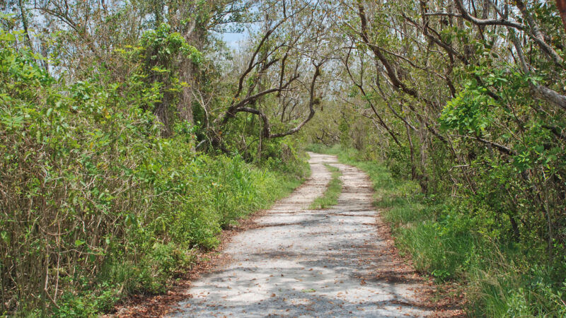
Two track road through tropical forest
Nearing Main Park Road on the Rowdy Bend Trail

Explore More!

Learn more about Everglades National Park

Lily dotted swamp with prairie to the horizon beyond Everglades National Park In 1.5 million acres across South Florida, Everglades National Park has outdoor experiences from accessible boardwalks and paved trails to rugged adventures in harsh wilderness.

Slideshow

See our photos of Snake Bight and Rowdy Bend


Nearby Adventures

More worth exploring along Everglades Main Park Road

Boardwalk to tree island Mahogany Hammock Trail Mahogany Hammock is a tree island, a tropical oasis in the Everglades “river of grass,” where the short boardwalk trail immerses you in the jungle-like hammock.
Boardwalk in a mangrove forest West Lake Mangrove Trail At West Lake, the Mangrove Trail loops through a shady tunnel, showcasing the protector of Florida’s coastline, the mighty mangrove, along the shores of a brackish lake.
Trail through mangroves Christian Point Trail The Christian Point Trail is one of the more challenging trails in Everglades National Park, leading you deep into the mangrove forest along Florida Bay.
Mangrove-lined lake Bear Lake Trail Everglades Paralleling the former Homestead Canal, the Bear Lake Trail takes you on a journey through tropical hammock and mangrove forests along a road scooped from the canal diggings.

Park Maps Reserve Campsite Official Website

  • Author
  • Recent Posts
Sandra Friend
Sandra Friend
Author of 45 books, Sandra Friend established FloridaHikes.com in 2006 to expand on the field research she'd completed for her first six hiking guides. She has been honored with lifetime achievement awards from the Florida Trail Association and the Florida Outdoor Writers Association.
Sandra Friend
Latest posts by Sandra Friend (see all)
  • Michael Crotty Bicentennial Park - November 3, 2026
  • A.J. Henry Park - November 1, 2026
  • Okeeheelee Nature Center Trails - October 22, 2026
Category: Biking, Day Hikes, Hikes, Loop Hikes, South Florida, Southeast Florida, TrailsTag: Birding, Botanical, Everglades, Everglades National Park, Flamingo, Florida Bay, Historic Sites, Homestead, Mangroves, Miami, National Parks, Observation Decks, Wildlife Viewing

Sidebar

FarOut Guides

Our comprehensive trail logistics presented on offline maps:

Florida National Scenic Trail (1,500 miles)
Florida Keys Overseas Heritage Trail (108 miles)
Eastern Continental Trail in Florida (92 miles)


We earn a small commission on sales through these links. Thanks for your support!


Our Guidebooks

We’ve written Florida guidebooks for over 25 years. These include South Florida destinations.

Book cover with woman hiking through palms with baby carrier
Book cover of Florida Trail Hikes
The Florida Trail Guide fifth edition

Explore More

Newest Articles for South Florida

Shelter in cypress strand along boardwalk beside channel Lake Istokpoga Park
Waving golden grasses in a flatwoods-edged prairie Paynes Creek Flatwoods Trail
View of creek far below over railing Paynes Creek Historic Trail
Two track amid lush forest Fakahatchee East Main Trail

  • Facebook
  • Flickr
  • Instagram
  • Pinterest
  • Substack
  • Vimeo

FIND A TRAIL OR PARK

METROS: Bradenton. Clearwater. Crestview. Daytona Beach. Destin. Fort Lauderdale. Fort Myers. Fort Walton Beach. Gainesville. Jacksonville. Kissimmee. Lakeland. Melbourne. Miami. Naples. Ocala. Orlando. Panama City Beach. Pensacola. Port St. Lucie. Punta Gorda. St. Petersburg. Sanford. Sarasota. Sebring. Stuart. Tallahassee. Tampa. Vero Beach. West Palm Beach.

MULTI-REGION: Atlantic Coastal Ridge. Atlantic Coast. Bartram Trail. Big Bend. East Coast Greenway. Everglades National Park. Florida National Scenic Trail. Gulf Coast. Lake Wales Ridge. WATERWAYS: Indian River Lagoon. Intracoastal Waterway. Kissimmee River. St. Johns River. Withlacoochee River.

NORTHWEST FLORIDA: Altha. Apalachicola. Apalachicola National Forest. Big Bend Scenic Byway. Blackwater River State Forest. Blountstown. Bonifay. Bristol. Bruce. Cantonment. Cape San Blas. Carrabelle. Chattahoochee. Chipley. Crawfordville. DeFuniak Springs. Eastpoint. Ebro. Eglin Air Force Base. Freeport. Fountain. Gulf Breeze. Gulf Islands National Seashore. Holt. Madison. Marianna. Milton. Monticello. Mossy Head. Munson. Navarre. Navarre Beach. Newport. Niceville. Panacea. Panama City . Perdido Key. Ponce De Leon. Port St. Joe. Quincy. Santa Rosa Beach. Sopchoppy. South Walton. St. George Island. St. Marks. St. Marks NWR. Sumatra. Vernon. Wakulla. Wewahitchka. Woodville. WATERWAYS: Apalachicola River. Blackwater Bay. Blackwater River. Chipola River. Choctawhatchee Bay. Choctawhatchee River. Coastal Dune Lakes. Ochlockonee Bay. Perdido River. St. Marks River. Wacissa River. Wakulla River. Yellow River.

NORTH FLORIDA: Alachua. Amelia Island. Archer. Baldwin. Branford. Bronson. Bunnell. Callahan. Cedar Key. Chiefland. Crescent City. Cross City. Cross Creek. Dowling Park. Ellaville. Fanning Springs. Fernandina Beach. Flagler Beach. Fort White. Glen St. Mary. Green Cove Springs. Hawthorne. High Springs. Inglis. Jacksonville Beaches. Jacksonville Northshore. Jasper. Jennings. Keystone Heights. Lake Butler. Lake City. Live Oak.Macclenny. Mandarin. Mayo. Mayport. Micanopy. Middleburg. Old Town. Olustee. Orange Park. Osceola National Forest. Palatka. Palatka-Lake Butler Trail. Palm Coast. Palm Valley. Perry. Ponte Vedra. Rodman. Salt Springs. St. Augustine. Starke. Steinhatchee. Suwannee. Suwannee River Wilderness Trail. Suwannee Springs. Talbot Islands. Timucuan Preserve. Trenton. Waldo. Welaka. White Springs. Williston. Worthington Springs. Yankeetown. WATERWAYS: Santa Fe River. St. Marys River. Suwannee River. Tolomato River. Upper Withlacoochee River.

CENTRAL FLORIDA: Altamonte Springs. Apollo Beach. Apopka. Astatula. Astor. Auburndale. Bartow. Babson Park. Bayport. Belleview. Bithlo. Brandon. Brooksville. Bushnell. Canaveral National Seashore. Cassadaga. Christmas. Chuluota. Citrus Springs. Clearwater Beach. Clermont. Coast to Coast Trail. Cocoa. Cocoa Beach. Cross Florida Greenway. Crystal River. Dade City. De Leon Springs. DeBary. Deland. Deltona. Dunedin. Dunnellon. Edgewater. Enterprise. Eustis. Ferndale. Fort Meade. Frostproof. Geneva. Gibsonton. Haines City. Hernando. Hernando Beach. Holopaw. Homosassa. Inverness. Kenansville. Kissimmee. Lake Mary. Lake Wales. Largo. Leesburg. Lithia. Longwood. Lutz. Maitland. Malabar. McIntosh. Melbourne Beach. Merritt Island. Merritt Island NWR. Mims. Mount Dora. Narcoossee/Lake Nona. New Port Richey. New Smyrna Beach. Nobleton. Oak Hill. Oakland. Ocala National Forest. Ocklawaha. Ocoee. Oldsmar. Orange City. Ormond Beach. Osteen. Oviedo. Paisley. Palm Bay. Plant City. Poinciana. Polk City. Ponce Inlet. Port Orange. Ridge Manor. Riverview. Ruskin. Safety Harbor. Silver Springs. Sorrento. Spring Hill. St. Cloud. Tarpon Springs. Thonotosassa. Titusville . Umatilla. Viera. Walt Disney World. Weeki Wachee. Weirsdale. Wimauma. Windermere. Winter Garden. Winter Haven. Winter Park. Winter Springs. Withlacoochee State Forest. Withlacoochee State Trail. Yeehaw Junction. Zephyrhills. WATERWAYS: Alafia River. Halifax River. Hillsborough River. Lake Apopka. Little Manatee River. Ochlawaha River. Rainbow River. Tampa Bay. Wekiva River. Wekiva River Basin.

SOUTHWEST FLORIDA: Alva. Boca Grande. Cape Coral. Charlotte Harbor. Ding Darling NWR. Ellenton. Englewood. Estero. Immokalee. Marco Island. North Port. Osprey. Palma Sola. Palmetto. Pine Island. Port Charlotte. Sanibel Island. Venice. WATERWAYS: Caloosahatchee River. Manatee River. Myakka River. Pine Island Sound.

SOUTH FLORIDA: Arcadia. Basinger. Big Cypress National Preserve. Big Cypress Seminole Reservation. Big Cypress Swamp. Bowling Green. Clewiston. Everglades City. Indiantown. LaBelle. Lake Okeechobee Scenic Trail. Lake Placid. Lakeport. Moore Haven. Okeechobee. Ortona. Pahokee. Palmdale. Port Mayaca. South Bay. Wauchula. Zolfo Springs. WATERWAYS: Fisheating Creek. Lake Okeechobee. Peace River.

SOUTHEAST FLORIDA: Biscayne Bay. Biscayne National Park. Boca Raton. Boynton Beach. Coconut Creek. Coral Gables. Coral Springs. Davie. Delray Beach. Fellsmere. Flamingo. Fort Pierce. Hobe Sound. Hollywood. Homestead. Indrio. Jensen Beach. Juno Beach. Jupiter. Jupiter Farms. Key Biscayne. North Hutchison Island. Ocean to Lake Greenway. Palm Beach. Palm Beach Gardens. Pompano Beach. Redland. Sebastian. South Hutchinson Island. WATERWAYS: Florida Bay. St. Lucie River.

FLORIDA KEYS: Big Pine Key. Islamorada. Key Largo. Key West. Marathon. Overseas Heritage Trail.


©2006-2026, Sandra Friend & John Keatley | Disclosure | Site Index | Work with Us | Advertise with Us | Terms of Service and Privacy Policy

Florida Hikes PO Box 93 Mims FL 32754 | Contact
