
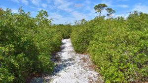
For a short hike, the trail at South Lake Conservation Area is surprisingly spunky. You wouldn’t assume that driving past, or even from the trailhead.
But once you’re on the main loop, it leads you up and over the Atlantic Coastal Ridge a few times, making for a hilly, scenic hike.
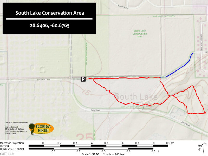
The trailhead kiosk map shows two loop trails, so we came back to scout out alternate routes. What we found is that, in reality, only one loop is a viable hike.
That’s the one that starts at the kiosk and enters the woods there. The outer loop was not at all maintained on our last visit, so we’ve left it off the map.
 Hiking through a tunnel of scrub on the main loop
It starts from a side trail that leads from an alternate trailhead, a back gate for pedestrians from a dead-end road in the adjacent Lantern Park neighborhood.
However, even with some creative bushwhacking to connect open sections, we managed to lose it entirely in a thicket of overgrowth which worsened at the back of the preserve.
 Trying to follow the overgrown path
So our writeup below focuses on the main loop, which is clear and easy to follow. It surprised us with a visit by two Florida scrub-jays, so it was definitely worth the hike!

Resources





Disclosure: As authors and affiliates, we receive earnings when you buy through our links. This helps us provide public information on this website.
Overview
Location: Titusville
Length: 1.2 mile loop
Trailhead: 28.6406, -80.8765
Address: 4500 Lancaster Ln, Titusville
Fees: Free
Restroom: None
Land manager: Brevard County
Phone: 321-264-5185
Open sunrise to sunset. No dogs permitted. Most of this hike is out in the open. Use sun protection.
While bicycles are welcome, soft sand is a big part of this loop through the scrub. We don’t recommend biking this loop.
However, cyclists may find it useful to cut through here on the grassy stretch between Lantern Park and the main trailhead.
Just around the corner from this preserve is an entrance to Salt Lake WMA, which adjoins this preserve and has forest roads you can bike.
Directions
From Interstate 95 exit 223, Mims, drive west on SR 46 one block to Carpenter Rd. Turn left. Continue 2.2 miles south to the four-way stop at Dairy Rd. Turn left. Within a mile, you pass a trailhead on the left for Salt Lake WMA and the road curves, changing its name to Ford Rd. Turn right at the next crossroad into the trailhead parking area.
Lantern Park residents can enter through a back gate stile at the end of Lancaster Ln. There is no parking here, but a prominent kiosk. You could lock a bike to the fence.
Follow the clear path that diagonals away to the right of the kiosk. It’s what would have been Lancaster Ln if the subdivision kept growing.
Turn right at the grassy berm along the ditch and you’ll see the main loop coming in from the left where we describe it at mile 0.9, below.
 The back gate in Lantern Park
Hike
A walk-through stile leads from the parking area to a long, straight forest road paralleling a deep canal, dug back when this area was a dairy.
The trailhead kiosk is just a little ways up on the right. It shows the map with both loops. Our route follows the inner loop. Turn right.
 Footpath into the scrubby flatwoods
The trail is a narrow sandy path through scrubby flatwoods with a dense understory of scrub. It is sporadically marked with yellow diamonds on posts.
Tall longleaf pines – and the bleached remains of pine trunks – tower above the landscape. Don’t be surprised to see an osprey or bald eagle perched on one, fussing.
 A young longleaf pine gains a foothold in this transition zone
Passing by scrub hickories and diminutive magnolias, the deeper into the preserve you go, the more it transitions to scrub.
It was around this point, well into the diminutive scrub forest, that we saw first saw blurs of blue overhead and heard the distinctive call of Florida scrub-jays.
While the vegetation adjoining the trail is thick, the textures are complex. Smilax vines spill over the rounded forms of saw palmetto.
Bracken ferns rise from the bright white sand. In early summer, many tarflower were blooming, attracting bees and butterflies.
 The first of many panoramic views
The trail slowly leads up to the top of a ridge, but you definitely notice the ascent. Turn around to be rewarded with a panorama of the scrub landscape to the northwest.
Look down into the leaf litter, too. On one visit, we also had a six-lined racerunner leading the way up and over this ridge.
 Coming downhill off the first ridge
The descent from the ridge is much steeper than the climb up. Once the trail levels out, it reaches its first junction at 0.4 mile, in front of two tall pines.
You’ll return to this junction later in the hike. It’s the return side of the near loop to the trailhead, which nets a 0.8 mile loop if you turn here.
 Looking back at the two trail junctions after passing them
For now, pass it by, as well as the next junction immediately after it on the left. Continue through this relatively flat area in the scrub.
It was in a clearing along this part of the trail that two Florida scrub-jays settled into the trees near us, curious as to why we were there.
 Watching the second scrub-jay. See our video at the top of the page for both.
We could see the sentinel of the family – the one that sounds the alarm – farther out on a taller tree. When it called, they left.
Passing another tall pine, the trail emerges to a broad sand road that cuts across the preserve. Turn right to stay on the outer loop.
 John walking along the sand road
It pops at out a retention pond that is also visible from Dairy Rd as you drive by. Sometimes a hawk or osprey will hang out in this area.
There was a pass-through stile in the fence to enable a walk over to Salt Lake WMA, but it’s been blocked off. Across Dairy Rd, Salt Lake WMA also has some nice hiking.
 The retention pond along Dairy Rd
The trail turns left to follow its edge and then starts climbing up into the scrub. Through a break in the trees, a wetland is visible in a swale.
Where the trail reaches a post with an obvious water crossing up ahead, you’re halfway through the hike. Turn left and start climbing uphill through a tunnel of scrub.
 The sharp turn off the perimeter trail
It’s a surprisingly steep climb. We heard both Eastern towees and more Florida scrub-jays in the scrub forest as we hiked uphill.
At the crest of the hill is another fine panorama, this one to the southwest. It continues as you descend until the scrub surrounds the trail again.
 View along the descent
Gopher apple grows profusely here, so it wasn’t a surprise when we came across a gopher tortoise and found its burrow.
As the trail flattens out a bit, there is a large wetland area sweeping off to the left in a bowl in the scrub.
 Low bush blueberries near the wetland
After another climb, the trail reaches the sand road that you were on earlier, but at a point farther north.
Cross it and continue along the narrow corridor through the scrub. It feels like a hallway between the trees.
 Junction of the sand road and the trail
Small grassy patches open up spots between the otherwise dense sand live oaks, Chapman oaks, and myrtle oaks.
Once again, you’re in the territory of the one scrub-jay family we know to be here, and there might be another opportunity to spot them.
The trail comes to a T intersection, sealing the far loop. Turn right. Coming to the next junction almost immediately, turn right and continue uphill.
Scrub hickories grow profusely in the understory. Climb up to the top of the ridge through another hallway of scrub oaks.
 John at the crest of the hill
Reach the crest of the hill and descend to the bottom, a gentle roller-coaster through the scrub. The trail becomes grassy underfoot, with grapevines tangled through the understory.
At 0.9 mile, the trail emerges from the scrub onto a broad mowed area at a marker pointing the way you came.
 Making the final descent off the scrub ridge
The trail to the right is the side trail leading to the Lantern Park neighborhood and to the overgrown outer loop, if you want more places for birding.
To stay on the return loop to the trailhead, turn left. This is the least interesting part of the preserve as it’s just a long grassy strip adjoining a deep ditch.
 The grassy strip along the ditch
We’ve spotted rabbits along it, and lots of wildflowers, including passionflower and dayflower. Alligators or herons may be at the bottom of the ditch.
Pass the trailhead kiosk and reach the stile in the fence out to the parking area, completing this 1.2 mile hike.
 We’ve only seen scrub-jays this close on one of many visits, but we are glad to know they are here
Trail Map
Explore More!
Slideshow
See our photos of South Lake Conservation Area
Nearby Adventures
 South Lake Trail Culminating at a breezy observation platform with a panorama of marshy South Lake, this easy Titusville hike is both short and scenic.
 Indian Mound Station Sanctuary Spot Florida scrub-jays and a fascinating diversity of plants while traversing a historic site on a 1.9 mile hike at the north end of Titusville.
 Salt Lake Hiking Trail Circling the central pine flatwoods of the uplands between the lakes of Salt Lake WMA, the 4.1-mile Salt Lake Hiking Trail is a great birding destination.
 Buck Lake Conservation Area East Watch for flashes of blue as Florida scrub-jays flit between shrubs on scrubby islands along the eastern loops of 9,600-acre Buck Lake Conservation Area.

- Baseline Trails - November 7, 2026
- Hal Scott Yellow Trail - November 3, 2026
- Hal Scott Preserve - October 28, 2026