
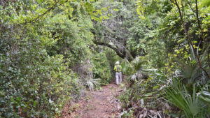
Hidden in plain sight where North Titusville and Mims meet east of Interstate 95, Indian Mound Station Sanctuary protects 147 acres.
Bisected by Parrish Rd, a significant portion of the preserve is low oak scrub suitable for Florida scrub-jays.
 Florida scrub-jay near the Parrish Rd pass-thru
Yet there are also scrubby flatwoods with towering pines, bayheads, and a ridge with a hardwood hammock.
Some of the trees within the preserve will surprise you with their size and girth, particularly along the edges of the herbaceous marshes.
 Sizable oaks edge the largest marsh
The preserve’s name reflects the human history of this landscape. “Station” comes from a six mile mule-drawn tramway which ran between Salt Lake and Titusville in 1875.
It used an ancient burial mound as a landmark. Located off-trail, the mound is only briefly noticeable from the footpath but very obvious from satellite images.
 Pines top the large mound
Resources





Disclosure: As authors and affiliates, we receive earnings when you buy through our links. This helps us provide public information on this website.
Overview
Location: Titusville
Length: 1.9 miles
Trailhead: 28.65560, -80.85946
Address: 2650 Glendale Blvd, Mims
Fees: Free
Restroom: By the Holder Park picnic pavilion
Land manager: Brevard County
Phone: 321-264-5185
Day use only. No bicycles, smoking, or pets. Trails may be soggy and overgrown during the summer season; use insect repellent.
Directions
From Interstate 95 exit 223, Mims, exit onto SR 46 and drive east a quarter mile to Holder Rd. Turn right and drive south a half mile. Turn left onto Holder Park Dr and follow it into the park, where it becomes Glendale Blvd. Turn right towards the picnic pavilion before the ballfield. Continue slightly past that parking spot to the back fence, where there is parking in front of the trailhead kiosk for the sanctuary.
Hike
Walk through the gap in the fence. A photo of the map on the kiosk will help distinguish firebreaks from footpath.
Osprey cries resound overhead, despite the lack of water. At least one pair nests in the tall pines bordering Holder Park.
 Trailhead kiosk at Holder Park entrance
Orange-hued chalky bluestem grass illuminates the first firebreak edging the preserve. Cross it into a corridor of scrub.
Pass between a pair of oaks laden with Spanish moss. Round a curve into a drop through a low spot amid marsh vegetation.
 Low area
Rejoining the scrub, cross a broad firebreak. Emerge from a tunnel of oaks into scrubby flatwoods with scattered slash pines and clusters of saw palmetto.
Tall grasses wave in the next firebreak at a quarter mile. Tunnel into the oak scrub. A yellow-tipped low wooden post confirms the route.
 Low blaze post
Approaching Parrish Rd, swing right along the fenceline to a gap in the fence. There is no crosswalk; watch for cars.
Cross and enter the gap at the kiosk on the south side of the road at a half mile.
 Parrish Rd crossing
The south portion of the preserve is distinctly different. Low scrub fronts the fenceline, yet the footpath enters a palm hammock. Footing is a bit rough.
Through a screen of low shrubs, note a line of tall pines to the west. They top the ancient burial mound.
 Among the palms
Leave the cabbage palms behind for a worn track through scrubby flatwoods.
A tenth of a mile from the kiosk, a yellow-tipped post calls attention to the start of the loop. Turn left.
 Marker where the loop begins
Transition to an immersion in an oak scrub corridor and then back into scrubby flatwoods.
Past a grassy gap in the forest, deer’s tongue blooms in profusion in fall. Foamy clusters of deer moss rest atop fallen leaves.
 Scrubby flatwoods
Approaching tall pines, pass the next post at a T intersection. Make a right.
The yellow-tipped confirmation post is well hidden among the scrubby oaks on the right.
This broad, grassy forest road meets a wall of moss-draped oaks and a large mound of grapevines. Take the less obvious left fork through a slight dip.
 Grapevine mound
Around a curve, the grassy path passes between tall loblolly bay trees. Peer between them to see a herbaceous marsh beyond.
Follow the curve towards a transition into pine flatwoods with towering slash pines.
 Curving towards the pines
At 0.7 mile, a yellow marker denotes a right turn off the forest road onto a footpath.
Rising into scrubby flatwoods, the path quickly meets a T with another marker. Turn right.
 First of the two turnoffs
Curve into a gentle approach to a series of live oaks gleaming under their burden of Spanish moss.
Just as this forest road broadens, a marker denotes a left turn into the oak hammock. Facing a herbaceous marsh, the trail curves right.
 The turnoff is just past these live oaks
Carved along the ecotone between the oak hammock on the bluff and the marsh, this is the most scenic part of the hike.
Footing can be challenging thanks to saw palmetto trunks.
Curtains of Spanish moss dangle from above, the canopy providing dappled shade. Yellow blazes mark some of the trees.
 Along the marsh edge
Reaching a line of pines, it’s obvious this footpath is paralleling a forest road. Beyond a large loblolly bay, a slight promontory provides a view across the vast marsh.
At a mile, step into a clearing under the oaks. The former route of this footpath is blocked near the marsh by a large fallen tree.
 Exit to the forest road
A freshly installed yellow-tipped marker guides the route to the adjoining forest road. Turn left. Drop through a low spot where ferns thrive.
Reaching a junction of forest roads, turn left. Make a left again at a marker at the next junction.
 Junction of forest roads
Grapevines mound downhill towards the marsh under the pines along this forest road.
Approaching the pines, watch for a marker on the right. Turn off the forest road into this scrubby corridor.
 Turnoff into the oaks
Twist and wind between the scrub oaks and saw palmetto towards the scrubby flatwoods beyond.
Gaining elevation, cross a small prairie dotted with cabbage palms. Chalky bluestem waves in the breeze.
 First prairie
A second prairie has a less obvious footpath. Look for the marker in the distance somewhat to the right and aim for it.
Cross a grassy forest road to a narrow pathway under the pines. Red maple and bay crowd in as the trail emerges at the end of the loop at 1.4 miles.
 Exit to Parrish Rd
Turn left at the yellow marker and walk back through the flatwoods and palm hammock to exit to the kiosk at Parrish Rd.
Cross the road and backtrack the half mile through scrubby flatwoods and scrub, emerging at Holder Park to finish this 1.9 mile hike.
 Final stretch of scrubby flatwoods
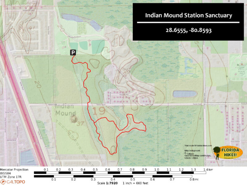
Trail Map
Explore More!
Video
Hiking Indian Mound Station Sanctuary
Slideshow
See our photos from Indian Mound Station Sanctuary
Nearby Adventures
 South Lake Trail Culminating at a breezy observation platform with a panorama of marshy South Lake, this easy Titusville hike is both short and scenic.
 South Lake Conservation Area A scrub preserve on the Atlantic Coastal Ridge in Titusville, South Lake Conservation Area provides a surprisingly hilly loop hike through the territory of Florida scrub-jay families.
 Chain of Lakes Park Buffering a green ribbon of Indian River Lagoon shoreline from US 1, Chain of Lakes Park offers dozens of ways to put together a walk through the wetlands.
 Fox Lake Sanctuary Protecting more than 2,500 acres along the western edge of Titusville, Fox Lake Sanctuary provides an immense landscape for exploration.

- Hal Scott Yellow Trail - November 3, 2026
- Hal Scott Preserve - October 28, 2026
- Tradewinds Park - October 27, 2026