
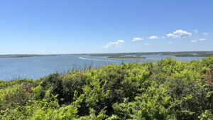
Along Florida’s Atlantic Coast, the prominent feature of Turtle Mound has undoubtedly been a navigational aid for centuries.
It is an oyster shell midden rising 35 feet above the Mosquito Lagoon, constructed by the Timucua around 800 A.D.
 View from the southern observation deck atop the mound
The views from the top are unsurpassed in the Central Atlantic region of Florida, sweeping to the horizon at all compass points.
To climb to this perch, a steeply pitched boardwalk ascends the forested summit of the midden. A lesser-known path follows its base.
 Path at the base of the midden
Resources





Disclosure: As authors and affiliates, we receive earnings when you buy through our links. This helps us provide public information on this website.
Overview
Location: Apollo Beach, Canaveral National Seashore
Length: 0.5 mile round-trip
Trailhead: 28.93048, -80.82564
Address: 7611 S. Atlantic Ave, New Smyrna Beach
Fees: $25 per vehicle, receipt good for 7 days
Restrooms: At the visitor center
Land manager: National Park Service
Phone: 386-428-3384
Open sunrise to sunset. Dogs are not permitted on this trail.
Directions
From Interstate 95 exit 249A for SR 44, follow SR 44 east into New Smyrna Beach for 5.2 miles to cross the causeway to the barrier island. The road will arc to the right, becoming A1A. Drive another 7 miles south to the Canaveral National Seashore park entrance. Continue down the park road about a half mile and park on the right.
Hike
The northernmost of the park’s hiking trails, Turtle Mound begins as a boardwalk at the north end of a series of parallel parking spaces on the west side of the park road.
Follow this flat surface past walls of underbrush where spiky red blooms of coral bean poke out of vine-covered saw palmetto each spring.
 Entrance boardwalk
At a T intersection, a ramp leads to a lagoonside picnic area on the left, while the boardwalk trail continues to the right. The railings give a clue that the hike isn’t staying flat.
The boardwalk rises, gently at first, zigzagging through and above the coastal hammock as it climbs to Turtle Mound.
 Climbing beneath the trees
Pass under the outstretched limbs of an oak providing a spot of shade before the boardwalk emerges into the open.
More steeply graded, it continues its zigzag upwards, now high above the forest below, passing a bump-out for a bench before reaching the top of the mound.
 Lagoon view towards the mainland
Straight ahead is a shaded overlook with an outstanding view of the Indian River Lagoon.
To the right, the observation deck at the end of a short climb offers a sweeping panorama of the Atlantic Ocean beyond the forested dunes.
 View north
To the left, a similarly short climb reaches an open observation deck with an astounding perspective on the lagoon’s coastline and islands.
Descending, enjoy the teal streak of the Atlantic above the vegetation until the curve past the bench.
 Descent from Turtle Mound
Reaching the base of the sloped boardwalk at a quarter mile, continue straight ahead down the short ramp towards the picnic area.
Take the beaten path to the right, a white line curving between cabbage palms and mangroves.
 Follow this path behind the mound
Outlined by posts, this lesser-known round-trip follows the base of Turtle Mound along a wave-lapped mangrove shoreline.
Walk across a spill of oyster shells. Further along, the forested midden has been stabilized with wire covering clumps of shells.
 Pathway outlined by posts
Tropical trees emerge from the man-made hillside, including a large specimen of nakedwood, also called Simpson’s stopper. It has no bark and a skunky aroma.
At a clearing where the trail curves, the shape of Turtle Mound is now obvious by the way the shells spill out onto flatter ground.
 Spill of shells at the base of Turtle Mound
Emerge from a mangrove tunnel onto a small spit of beach, waves gently washing along its edge.
Turn around and follow the outlined path back to the boardwalk, reaching the parking area. Together, the two trails tally a half mile.
 Waterfront at the end of the trail
Trail Map

Explore More!
Learn more about Canaveral National Seashore
 Canaveral National Seashore Canaveral National Seashore protects 58,000 acres of maritime hammocks, dunes, and coastline north of Cape Canaveral, a natural sandy cape that formed where ocean currents meet.
Video
A walk above and below Turtle Mound
Slideshow
See our photos from this hike
Nearby Adventures
 Eldora Village Settled in the late 1800s south of New Smyrna, Eldora thrived as a rural agricultural community for more than a decade. Today, the Eldora State House tells its story.
 Eldora Hammock Trail Near the ghost town of Eldora, the Eldora Hammock Trail loops through the beauty of a lush coastal hammock, highlighting a semi-tropical understory in deep shade.
 Castle Windy At Canaveral National Seashore, Castle Windy is the only trail that takes you from the Atlantic Ocean to the Indian River Lagoon, a shady walk through a coastal hammock to a windswept shoreline.
 Smyrna Dunes Park At Smyrna Dunes Park, this 2.4-mile hike scenic coastal hike is largely along an accessible boardwalk, with side trips off to the sea and inlet via more rugged approaches.

- Hal Scott Yellow Trail - November 3, 2026
- Hal Scott Preserve - October 28, 2026
- Tradewinds Park - October 27, 2026