
Weedon Island Preserve is one of Florida’s most significant archaeological sites. A dugout canoe was discovered in the mud here and carbon-dated to 900 A.D.
One site in the preserve, Yat Kitischee, was occupied for more than a thousand years. Artifacts found from what is called the Weeden Island culture date back to 200 A.D.
 A piece of the canoe is on display at the preserve
Built by the Florida Trail Association in the 1980s, the initial trail system grew around the core upland area called Weedon Hammock when this was a Florida State Park.
The county took over management of Weedon Island in 1999. Spur trails with boardwalks to scenic points now extend from the original natural surface trails.
 In winter, the preserve is a birder’s delight
On a trail system of less than four miles, you can hike it in many different ways. There are both spur and loop trails as a part of the trail system, so round-trip hikes are necessary.
Access points are from the Cultural and Natural History Center, which hosts outstanding exhibits, and from the Boy Scout trailhead.
 Exhibit Hall
Resources




Disclosure: As authors and affiliates, we receive earnings when you buy through our links. This helps us provide public information on this website.
Overview
Location: St. Petersburg
Length: 4.6 miles
Trailhead: 27.8476, -82.6080
Address: 1800 Weedon Drive NE, St. Petersburg
Fees: Free
Restroom: at the visitor center
Land manager: Pinellas County
Phone: 727-453-6500
No pets or bicycles permitted. Open 7-sunset except Christmas and the day after Thanksgiving. Closing time is posted at the front gate.
Be sure to use insect repellent and sun protection. Parts of the trail system have no shade, and the parts that are shady tend to have a lot of mosquitoes.
Open Thu-Sat 9-4 and Sun 11-4 (closed holidays), the Cultural and Natural History Center immerses visitors in exhibits along a timeline of this island.
Directions
From Interstate 275, take the Gandy Blvd (US 92) exit and head east for 2.7 miles, turning off onto San Martin Blvd just after the large racing/poker facility on the right. Continue a mile and turn left on Ridgeway Dr at the Great Florida Birding Trail sign. It becomes Weedon Dr and enters the preserve. There are two parking areas: a very small one for the Boy Scout Trail and the large one at the Cultural and Natural History Center.
Hike
Start behind the Cultural and Natural History Center by making a left on the paved Upland Trail, which leads through a stand of pines into scrubby flatwoods.
Interpretive signs point out key features. A quarter mile in, take a right on a paved path that quickly reaches the Bay Boardwalk into the coastal mangrove forest.
 Bay Boardwalk
Rounding a corner, the boardwalk comes to an observation deck with a bench. This saltwater pond is a favorite fishing spot for osprey.
Tunneling deeper into the mangroves, the boardwalk makes a circle around the south side of the pond, passing another bench.
 Saltwater pond
When you reach a boardwalk to the right, follow it. This spur ends at the Bay Observation Platform, one of the locations where birders flock to watch the flocks of birds.
As tides drain Tampa Bay, the seagrass and mudflats are exposed. This makes for easy pickings for wading birds, especially the brilliant pink roseate spoonbills.
 Bay Observation Platform
Return along the spur to the main loop and turn right. The mangroves aren’t as tall in one spot, so you can see across their canopy, mangroves stretching out to the blue horizon.
The Bay Boardwalk ends at a junction where the paved Upland Trail ends at a picnic grove at 1.1 miles.
 Trail junction at the picnic grove
Turn right at the Boy Scout Loop sign to follow a footpath into the forest. The remainder of the hike is on natural surfaces and may get wet or mucky in places, especially after a rain.
Shaded by oaks and flanked by cabbage palms and palmetto, the sandy path winds through an upland forest. Pines stand tall above when the trail emerges into the sun.
 Under the oak canopy
At the next sign, turn right to head to Lookout Point. This narrow pathway becomes a berm that tunnels into the mangrove forest, with the mangroves providing deep shade.
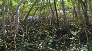
The pnuemataphores of the black mangroves march right up to the edges of the footpath. Ditches parallel the berm. Expect to see mangrove crabs in the tree limbs.
 Among the mangrove roots
Splotches of shade across the trail provide natural camoflauge for creatures crossing the berm, including alligators. Be cautious.
Walk across pine duff amid an unexpected stand of pines before the trail curves left. Through gaps between the mangrove roots, an open mudflat is visible.
 End of the tunnel ahead
Sunlight illuminates the sand underfoot as you draw closer to the end of this peninsula, Lookout Point. A picnic bench sits at the end of the trail.
Depending on the tide, you can ease your way out between the mangroves to the edge of Tampa Bay for a panorama stretching from the Gandy Bridge to MacDill Air Force Base.
 Tampa Bay view
Return the same way along the Lookout Point Trail, reaching the end of the mangrove tunnel and then the T intersection at 2 miles.
Turn right to start the Boy Scout Trail in earnest. It is what remains of a trail system built in 1984 by the Florida Trail Association that was called the Weedon Island Trail.
 The Boy Scout Trail
Stay right at the fork. The trail is broad and sunny , hemmed in by the understory of saw palmetto. A bench adjoins a bridge over a mangrove-lined waterway.
With a slight elevation gain just past the bridge, the trail is canopied by an oak hammock, a pleasant tunnel in the shade. Red circles with arrows serve as trail markers.
 Red marker on the Boy Scout Trail
At the next intersection, the spur to the right leads to Weedon Hammock. Emerge into an open fern-filled clearing with stately cabbage palms.
Trail’s end is in a thick tropical hammock at a picnic bench in a clearing shaded by ancient oaks. Return the way you came and turn right on the Boy Scout Trail.
 Palms in Weedon Hammock
Cross a bridge over a lazy waterway. At 2.3 miles, enter the mangrove forest again atop a slightly elevated berm. Open water is visible between the mangrove limbs.
There is no observation deck along this loop, but there are bridges, and a few locations have better views than others.
 Bridge on the Boy Scout Loop
The bridges around this loop have names painted on them. Cross a broad creek on the Lighter Knot bridge. A succession of short bridges over skinny streams follows.
These many bridges join the berms, likely dating to mosquito control days, to create a hiking route through the mangrove swamp.
 Hikers in the mangrove tunnel
Stay right at the junction after the Palm Bridge to go around the short loop counter-clockwise. Pop out within view of Weedon Drive and the Boy Scout trailhead.
Keep following this small loop around, crossing the North Bridge next, and you’ll end up back at Palm Bridge 2.8 miles into the hike.
 Sign near the Boy Scout trailhead
From Palm Bridge, backtrack along the route you hiked to this loop, skipping all the side trails. Oak Bridge leads out of the mangrove forest to the oak hammock.
Crossing 5 Feet Over Bridge, keep left at the next junction and pass by the turnoff to the Lookout Point Trail. Reach the picnic area at the Upland Trail junction at 3.4 miles.
 Five Feet Over Bridge
Skip the Bay Boardwalk and follow the Upland Trail straight ahead. Reach the back of the Cultural and Natural History Center and continue straight ahead.
Turn left at a trail map at the Paul Getting Memorial Trail sign and follow the boardwalk down a straightaway through the mangroves.
 Mangrove-lined pond
Come to an overlook on a mangrove-lined pond where the water is clear and shallow. Oysters cling to mangrove roots.
As the boardwalk continues out towards Riviera Bay, there is less shade. At 4.1 miles, make a left at the next junction and face the five-story observation tower in the distance.
 Approaching the observation tower
The boardwalk makes a gentle climb to the tower. Below, patches of open sand are obvious, with fiddler crabs scuttling across them under the mangroves.
Reaching the tower, climb to the top for the panoramic view of the mangrove forest on Weedon Island and of Riviera Bay opening out into Old Tampa Bay.
 Looking towards Riviera Bay
The city of St. Petersburg hugs the shoreline. Looking north, you can also see the skyline of Tampa on the horizon, beyond the sea of mangroves covering this peninsula.
Descend and follow the boardwalk, making a left when you reach the main trail. This loop continues through the mangroves, ending at the Uplands Trail.
 Cranes at a nearby port
Follow the Uplands Trail past a fenced-in display, showy tiles in the corner speaking to the Art Deco vintage of the control tower of what was once Grand Central Airport.
In 1929, this airport was built to provide commercial service to Daytona Beach and New York City. Used for pilot training in World War II, it closed permanently in the 1950s.
 Art deco tiles in the former control tower
Except for this unique artifact, all traces of the airport were removed after Weedon Island became a state park.
Continue back along the Upland Trail to the Cultural and Natural History Center to complete a 4.6 mile hike.
 Locations inside the control tower are labeled
Trail Map

Explore More!
Slideshow
See our photos from this hike
Nearby Adventures
 Sawgrass Lake Park Explore a maple swamp and an oak hammock on a pair of family-friendly loops along boardwalks and footpaths that lead to a tower on Sawgrass Lake.
 Boyd Hill Nature Preserve An oasis of natural landscapes in St. Petersburg features a nature center, bird of prey aviary, and 3.5 miles of hiking through several distinct habitats.
 John R. Bonner Nature Park A hidden gem surrounded by neighborhoods, John R. Bonner Nature Park offers excellent birding opportunities along short loop trails and a scenic boardwalk.
 Clam Bayou Nature Preserve Along an environmentally significant estuary of Boca Ciega Bay, Clam Bayou Nature Preserve offers well-established trails with several overlooks and a kayak launch

- Baseline Trails - November 7, 2026
- Hal Scott Yellow Trail - November 3, 2026
- Hal Scott Preserve - October 28, 2026