
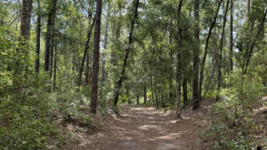
Within walking distance of historic downtown Inverness, Whispering Pines Park is a community resource for outdoor play.
Across 290 acres, it melds both sports and nature, with large ballfields and tennis/racketball courts, a public swimming pool, and disc golf.
 Park entrance
Under the treed canopy provided by the pines are playgrounds, a splash pad, numerous picnic pavilions, a butterfly garden, and even a group camp for youth groups.
An important part of the park is its trails. Mountain bikers will find some challenging hills on the one-way 2-mile marked singletrack on the slopes of the sandhills.
 Butterfly Garden at Whispering Pines Park
Five hiking trails, including a linear segment of the statewide Florida Trail, make up a color-coded trail network with multiple potential loops along it.
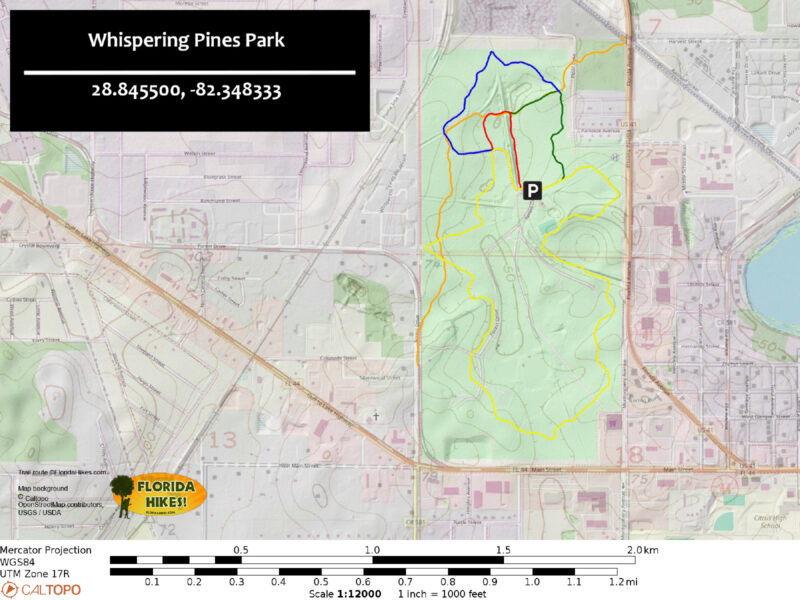
The hike we describe below strings together the Yellow and Blue Trails, spanning the park with one large loop.
 Trail maps at a trail junction
Resources





Disclosure: As authors and affiliates, we receive earnings when you buy through our links. This helps us provide public information on this website.
Overview
Location: Inverness
Length: 3.3 miles
Trailhead: 28.845500, -82.348333
Address: 1700 Forest Dr, Inverness
Fees: Free
Restrooms: At the front entrance, pool, and picnic areas
Land manager: City of Inverness
Phone: 352-726-3913
Open sunrise to 8 PM. Leashed dogs welcome. To reserve the group campsite along the Blue Trail, call the park in advance.
Directions
From the junction of US 41 and SR 44 just north of downtown Inverness, follow SR 44 west for 0.7 mile to a traffic light. Turn right on Forest Drive. In less than a quarter mile, the park entrance will be on the right. Inside the park, make a left at the large green sign. Follow signs along the park road to the tennis, racketball, and basketball courts and the pool. Passing the Butterfly Garden, the road ends at a parking area adjacent to this sports complex.
Hike
Starting at the parking area near the basketball and racket courts, look for a Yellow Trail sign and bench in the northeast corner.
These trail signs display a color-coded map and are they found in multiple locations along each route.
 Map sign at the trailhead
Beginning on a section of trail shared between the yellow, red, green, and blue blazed routes, head east for a tenth of a mile.
Turn left and stay with the Yellow Trail where the rest of the trails branch away from it.
Multicolored posts with arrows lead the way under the shade of mixed hardwoods, pines, and cabbage palms.
 Trail intersection
Although the paths are generally well marked, the disc golf courses can cause confusion at some points where they intersect with the hiking trails.
Crossing the orange-blazed Florida Trail at 0.3 mile, continue straight on the Blue Trail.
A right turn onto the Florida Trail at this junction leads to the Withlacoochee State Trail in 0.2 mile, where the orange blazes continue approximately 690 miles to Pensacola Beach.
 Orange-blazed Florida Trail
Around 0.8 mile, the Blue Trail crosses the Florida Trail again while passing by rustic picnic pavilions, a restroom, and a group campsite.
Blue posts lead east another 0.1 mile before reaching an intersection with the Yellow Trail. Turn right to explore the southern portion of the park along the yellow-blazed loop.
 Picnic pavilion
Songbirds chirp in the leafy canopy above as the trail follows a sandy corridor south for a half mile before emerging alongside the softball fields.
Cross the paved entrance road before entering the woods again. Follow yellow blazes past benches and through contoured terrain from historic phosphate mining operations.
 Near the entrance road
Although years of fire suppression have altered the historic natural landscapes of this forest, native wildflowers, tall pines, and orange-tinted soils reveal elements of a sandhill habitat.
Near the end of the loop, the sound of racket sports gradually becomes louder as the path approaches the tennis courts.
The trail runs alongside them. Round a final bend and return to the trailhead to complete a 3.3 mile circuit of the park.
 Through the pines
Trail Map
Explore More!
Access the Withlacoochee State Trail by following the Florida Trail to it
 Withlacoochee State Trail Tracing 44 miles of railroad history down forested corridors, past big lakes and city parks, and through quaint communities, the Withlacoochee State Trail is one sweet ride
Video
A walk through Whispering Pines Park
Slideshow
See our photos from Whispering Pines Park
Nearby Adventures
 Cooter Pond Park In downtown Inverness, Cooter Pond Park is a great place for birding and watching the turtles beneath the extensive boardwalk over the pond.
 Fort Cooper State Park Protecting woodlands and marshes around Lake Holathlikaha, Fort Cooper State Park preserves an important chapter of the Second Seminole War. An annual re-enactment relives the battle.
 Citrus Hiking Trail 39.1 miles. Savor a rugged hike through rolling hills and rocky terrain on one of Florida's longest backpacking loops when you take on the Citrus Hiking Trail near Inverness
 Annutteliga Hammock Trail Explore fascinating karst topography with exposed limestone under a shady canopy in the Withlacoochee State Forest, passing a primitive camping area along this 4.8 mile loop.

- Calusa Heritage Trail - November 5, 2026
- Scherer Thaxton Preserve - October 21, 2026
- Little Awesome Preserve - October 19, 2026