• Skip to main content
  • Skip to header right navigation
  • Skip to after header navigation
  • Skip to site footer
Florida Hikes logo

Florida Hikes

Hike Bike Paddle Camp Florida with authors Sandra Friend and John Keatley as your guides

  • Trails
  • Maps
  • Guidebooks
  • Hike
    • Scenic Hikes
    • Loop Trails
    • Dog-friendly Hikes
    • Hikes for Kids
    • National Parks in Florida
    • Florida State Parks
  • Bike
    • Major Bike Trails
    • Paved Bike Trails
    • Off Road Biking
    • Biking Articles
  • Paddle
    • Canoe & Kayak Rentals
    • Paddling Destinations
    • Paddling Articles
  • Camp
    • Cabin Rentals
    • Car Camping
    • Primitive Camping
  • Florida Trail
    • Plan your Hike
    • Best Scenic Hikes
    • Best Backpacking
    • Section Hiking
    • Thru-Hiking
    • Trail Updates
  • Travel
Panorama of lagoon shoreline and lagoon

Big Lagoon State Park

Explore a sweep of coastal forest and wetlands along one of Florida’s largest lagoons, with panoramas that stretch to Perdido Key and the Gulf of Mexico.

Pensacola (30.321489,-87.403733)   6.2 miles  

As the name suggests, lagoons are the centerpiece of Big Lagoon State Park, but only one is the Big Lagoon.

Its mirror-smooth expanse of saltwater is trapped behind dunes within sight and sound of the surf of the Gulf of Mexico.

Silhouette of tower foreground to expanse of water Observation Tower and boardwalks along Big Lagoon


Across Big Lagoon is Perdido Key, the facing shoreline protected as Gulf Islands National Seashore all the way to the eastern tip of the island.

Big Lagoon is edged to the east by Naval Air Station Pensacola, the birthplace of naval aviation, so the Blue Angels practice weekly in these skies.

Panorama of lagoon with ocean in distance From the top of the tower, you can see over Perdido Key to the Gulf of Mexico


Resources

Resources for exploring the area
50 Hikes in North Florida book cover North Florida Panhandle Explorers Guide book cover Hikers Guide to the Sunshine State book cover Paddlers Guide Florida Hiking the Gulf Coast book cover
 
Disclosure: As authors and affiliates, we receive earnings when you buy through our links. This helps us provide public information on this website.

Overview

Location: Pensacola
Entrance: 30.321489,-87.403733
Address: 12301 Gulf Beach Highway, Pensacola
Fees: $4 individual, $6 carload
Restrooms: at the West Beach and East Beach picnic areas
Land manager: Florida State Parks
Phone: 850-492-1595

Open 8 AM to sunset. Leashed pets welcome except on beaches.

Don’t assume brackish waters and soft white sands mean no alligators, because they do live in the lagoons and bask on these shorelines.


Directions


From the US 29 exit along Interstate 10 west of downtown Pensacola, head south on US 29 for 1.4 miles, turning right onto North W St. In 1.7 miles, turn right onto SR 296, continuing for 4.3 miles to N Blue Angel Parkway. Turn left and drive 7.7 miles. Make a right at SR 292. In 3 miles, turn left onto Bauer Rd. In 1.3 miles, the park entrance is directly across the intersection with Gulf Beach Highway.

About the Park

With 678 acres protected along Big Lagoon, Big Lagoon State Park is more than just a waterfront. But many visitors flock here for that water access.

Slender beaches and gentle shallows make the lagoon shoreline a popular spot for wading, splashing, and catching fish.

Waterway with natural beach, powerboat and paddlers The near expanse of Big Lagoon


Two swimming areas frame the waterfront. West Beach is closer to the campground and is home to a playground and picnic pavilions, including the large Governor’s Pavilion.

A boat ramp enables visitors water access to the lagoon with motorized watercraft.

Picnic pavilion on beach Both beaches are natural shorelines


East Beach is at the eastern tip of the park and entirely out in the open along the lagoon, with picnic pavilions surrounding its landmark observation tower.

The hand-launch for kayaks and canoes is here in a protected channel between Grand Lagoon and the open waters of Big Lagoon.

Kayakers in estuary channel Paddlers in the launch channel


The western gateway for the Great Florida Birding Trail, the park has a boardwalk loop and tower perfect for watching skimmers, herons, and pelicans.

Its interior uplands with with coastal dune ridges, sandhills, and baygalls are also productive for birding.

Osprey on nest Osprey nest along the Estuary Trail


Due to its vulnerable location between Pensacola Bay and the mouth of the Perdido River, the park has taken a beating during many hurricanes.

It’s not uncommon to show up and find a portion of the infrastructure closed for post-hurricane repairs months later. If you have a specific activity in mind, call ahead on its status.

Road between pines The park road between the beaches was closed on our last visit


Hiking

Extending into and connecting most corners of the park, there are more than 6 miles of interconnected hiking trails at Big Lagoon.

With access points just past the entrance station and at the campground, the white-blazed 3.1-mile Sand Pine Trail circles the uplands of the park.
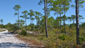
White blazed trail through pine forest Sand Pine Trail, Big Lagoon State Park Immersed in an intriguing blend of habitats in a coastal setting, this uplands hiking loop at Big Lagoon State Park showcases a variety of birds and native plants.

The Estuary Trail starts at the bridge to the campground over Long Pond and heads east, with nice views of both the pond and Grand Lagoon.

It branches in two directions halfway along the route, one arm terminating along Grand Lagoon at a picnic pavilion with a view.

Wooden deck with railing along coastal waterway Observation deck on Grand Lagoon


The other branch continues through the coastal scrub and reaches the East Beach parking area within sight of the Observation Tower Loop.

It’s a 2-mile hike between West Beach and East Beach via the Estuary Trail and its connecting boardwalks, including the spur out to Grand Lagoon.

Park sign for beaches in scrub forest The Estuary Trail connects the beaches and Grand Lagoon


A must-visit, the Observation Tower Loop is a half-mile walkway, a boardwalk for most of its length over the estuary and scrub where Grand Lagoon and Big Lagoon meet.

Connecting picnic pavilions at the very southeast tip of the park, its notable feature is the tall observation tower with its outstanding panorama of Big Lagoon.

Observation tower with condos in distance The observation tower is worth the climb


Paddling

Big Lagoon State Park is the westernmost launch point for the Florida Saltwater Circumnavigational Trail, a marked paddling route along Florida’s coastline.

The primary paddler put-in is accessed from the very end of the park road near the observation tower.

Paddlers in protected cove Paddlers headed out to Big Lagoon on the Florida Saltwater Circumnavigational Trail route


From this launch, you can either explore Grand Lagoon or paddle out into the open waters of Big Lagoon.

Canoes are available for paddling Long Pond, which adjoins the campground. That put-in is next to the beach side of the bridge over Long Pond.

Canoes on rack next to picnic shelter along waterway Canoes stored next to the Long Pond picnic shelter


Camping

Centered within the park, its campground provides a surprising amount of habitat and terrain diversity within its loops.

Choose a site within the inner loops to be well up atop the scrub ridge. Sites along the southern edge of the campground fringe the marshes.

Campsite along willow marsh One of the sites along the marsh


Each of the 75 campsites have water and electric hookups along with the usual picnic bench and fire ring.

Maximum size for an RV is 40 feet. A dump station is available. A central bathhouse includes a laundry facility.

Tent in campsite on ridge A campsite on the scrub ridge


Boardwalks connect the campground with the recreation area at West Beach and with the hiking trail system.

A half-mile loop trail extends through the campground from Long Pond to a boardwalk linking up through the scrub to the Big Lagoon Loop.

Boardwalk over scrub plants Boardwalk to campground from Grand Lagoon picnic shelter area


Trail Map

Big Lagoon Trail Map
Red: Sand Pine Trail. Purple: Campground Loop. Green: Estuary Trail. Brown: Observation Tower Loop.

Explore More!

Video

Slideshow

See our photos of Big Lagoon State Park


Nearby Adventures

Beach with posts outlining dunes Johnson Beach As part of Gulf Islands National Seashore, the windswept tip of Perdido Key goes on for miles at Johnson Beach. Discover natural habitats and wild shores along its length.
Beach with emerald waters and sea oats Perdido Key State Park With sand as white as fresh fallen snow, Perdido Key State Park offers Florida's westernmost public beach.
Sunrise at Gulf State Park Gulf State Park Stretching west from the tip of Perdido Key, Gulf State Park encompasses more than 6,000 acres of natural habitats on barrier islands between Orange Beach and Gulf Shores, Alabama.
White-topped pitcher plants Tarkiln Bayou Preserve State Park Conserving a vast swath of wetland habitats in low-lying areas along the Perdido River floodplain, Tarkiln Bayou Preserve State Park is home to four species of Sarracenia - pitcher plants - unique to the Gulf Coast.

Trail Map (PDF) Reserve Campsite Official Website

  • Author
  • Recent Posts
Sandra Friend & John Keatley
Articles jointly researched, written, and photographed by Sandra Friend & John Keatley, authors and publishers of FloridaHikes.com.
Sandra Friend & John Keatley
Latest posts by Sandra Friend & John Keatley (see all)
  • Hal Scott Yellow Trail - November 3, 2026
  • Hal Scott Preserve - October 28, 2026
  • Tradewinds Park - October 27, 2026
Category: Access by water, Beaches, Blueways, Camping, Day Hikes, Florida State Parks, Hikes, Launch Points, Loop Hikes, Nature Trails, Northwest Florida, Paddling, Parks, Places, TrailsTag: Accessible, Best Birding, Big Lagoon State Park, Birding, Boardwalks, Boating, Car Camping, Developed Camping, Family-Friendly, Fishing, Florida State Parks, Observation Decks, Observation Towers, Pensacola, Perdido Key, Picnic, Scenic Hikes, Swimming

Sidebar

FarOut Guides

Our comprehensive trail logistics presented on offline maps:

Florida National Scenic Trail (1,500 miles)
Florida Keys Overseas Heritage Trail (108 miles)
Eastern Continental Trail in Florida (92 miles)


We earn a small commission on sales through these links. Thanks for your support!


Our Guidebooks

We’ve written Florida guidebooks for over 25 years. These include Northwest Florida destinations.

Book cover with woman hiking through palms with baby carrier
Book cover of Florida Trail Hikes
The Florida Trail Guide fifth edition
Explorer's Guide North Florida & The Panhandle guidebook

Explore More

Newest Articles for Northwest Florida

Footpath in lush river hammock Florida Trail, Wakulla River
Expanse of lake Jackson View Park
Large pond with a boardwalk on its far shore Pedrick Pond Park
Sweep of bay beyond dunes and path through them Okaloosa Area

  • Facebook
  • Flickr
  • Instagram
  • Pinterest
  • Substack
  • Vimeo

FIND A TRAIL OR PARK

METROS: Bradenton. Clearwater. Crestview. Daytona Beach. Destin. Fort Lauderdale. Fort Myers. Fort Walton Beach. Gainesville. Jacksonville. Kissimmee. Lakeland. Melbourne. Miami. Naples. Ocala. Orlando. Panama City Beach. Pensacola. Port St. Lucie. Punta Gorda. St. Petersburg. Sanford. Sarasota. Sebring. Stuart. Tallahassee. Tampa. Vero Beach. West Palm Beach.

MULTI-REGION: Atlantic Coastal Ridge. Atlantic Coast. Bartram Trail. Big Bend. East Coast Greenway. Everglades National Park. Florida National Scenic Trail. Gulf Coast. Lake Wales Ridge. WATERWAYS: Indian River Lagoon. Intracoastal Waterway. Kissimmee River. St. Johns River. Withlacoochee River.

NORTHWEST FLORIDA: Altha. Apalachicola. Apalachicola National Forest. Big Bend Scenic Byway. Blackwater River State Forest. Blountstown. Bonifay. Bristol. Bruce. Cantonment. Cape San Blas. Carrabelle. Chattahoochee. Chipley. Crawfordville. DeFuniak Springs. Eastpoint. Ebro. Eglin Air Force Base. Freeport. Fountain. Gulf Breeze. Gulf Islands National Seashore. Holt. Madison. Marianna. Milton. Monticello. Mossy Head. Munson. Navarre. Navarre Beach. Newport. Niceville. Panacea. Panama City . Perdido Key. Ponce De Leon. Port St. Joe. Quincy. Santa Rosa Beach. Sopchoppy. South Walton. St. George Island. St. Marks. St. Marks NWR. Sumatra. Vernon. Wakulla. Wewahitchka. Woodville. WATERWAYS: Apalachicola River. Blackwater Bay. Blackwater River. Chipola River. Choctawhatchee Bay. Choctawhatchee River. Coastal Dune Lakes. Ochlockonee Bay. Perdido River. St. Marks River. Wacissa River. Wakulla River. Yellow River.

NORTH FLORIDA: Alachua. Amelia Island. Archer. Baldwin. Branford. Bronson. Bunnell. Callahan. Cedar Key. Chiefland. Crescent City. Cross City. Cross Creek. Dowling Park. Ellaville. Fanning Springs. Fernandina Beach. Flagler Beach. Fort White. Glen St. Mary. Green Cove Springs. Hawthorne. High Springs. Inglis. Jacksonville Beaches. Jacksonville Northshore. Jasper. Jennings. Keystone Heights. Lake Butler. Lake City. Live Oak.Macclenny. Mandarin. Mayo. Mayport. Micanopy. Middleburg. Old Town. Olustee. Orange Park. Osceola National Forest. Palatka. Palatka-Lake Butler Trail. Palm Coast. Palm Valley. Perry. Ponte Vedra. Rodman. Salt Springs. St. Augustine. Starke. Steinhatchee. Suwannee. Suwannee River Wilderness Trail. Suwannee Springs. Talbot Islands. Timucuan Preserve. Trenton. Waldo. Welaka. White Springs. Williston. Worthington Springs. Yankeetown. WATERWAYS: Santa Fe River. St. Marys River. Suwannee River. Tolomato River. Upper Withlacoochee River.

CENTRAL FLORIDA: Altamonte Springs. Apollo Beach. Apopka. Astatula. Astor. Auburndale. Bartow. Babson Park. Bayport. Belleview. Bithlo. Brandon. Brooksville. Bushnell. Canaveral National Seashore. Cassadaga. Christmas. Chuluota. Citrus Springs. Clearwater Beach. Clermont. Coast to Coast Trail. Cocoa. Cocoa Beach. Cross Florida Greenway. Crystal River. Dade City. De Leon Springs. DeBary. Deland. Deltona. Dunedin. Dunnellon. Edgewater. Enterprise. Eustis. Ferndale. Fort Meade. Frostproof. Geneva. Gibsonton. Haines City. Hernando. Hernando Beach. Holopaw. Homosassa. Inverness. Kenansville. Kissimmee. Lake Mary. Lake Wales. Largo. Leesburg. Lithia. Longwood. Lutz. Maitland. Malabar. McIntosh. Melbourne Beach. Merritt Island. Merritt Island NWR. Mims. Mount Dora. Narcoossee/Lake Nona. New Port Richey. New Smyrna Beach. Nobleton. Oak Hill. Oakland. Ocala National Forest. Ocklawaha. Ocoee. Oldsmar. Orange City. Ormond Beach. Osteen. Oviedo. Paisley. Palm Bay. Plant City. Poinciana. Polk City. Ponce Inlet. Port Orange. Ridge Manor. Riverview. Ruskin. Safety Harbor. Silver Springs. Sorrento. Spring Hill. St. Cloud. Tarpon Springs. Thonotosassa. Titusville . Umatilla. Viera. Walt Disney World. Weeki Wachee. Weirsdale. Wimauma. Windermere. Winter Garden. Winter Haven. Winter Park. Winter Springs. Withlacoochee State Forest. Withlacoochee State Trail. Yeehaw Junction. Zephyrhills. WATERWAYS: Alafia River. Halifax River. Hillsborough River. Lake Apopka. Little Manatee River. Ochlawaha River. Rainbow River. Tampa Bay. Wekiva River. Wekiva River Basin.

SOUTHWEST FLORIDA: Alva. Boca Grande. Cape Coral. Charlotte Harbor. Ding Darling NWR. Ellenton. Englewood. Estero. Immokalee. Marco Island. North Port. Osprey. Palma Sola. Palmetto. Pine Island. Port Charlotte. Sanibel Island. Venice. WATERWAYS: Caloosahatchee River. Manatee River. Myakka River. Pine Island Sound.

SOUTH FLORIDA: Arcadia. Basinger. Big Cypress National Preserve. Big Cypress Seminole Reservation. Big Cypress Swamp. Bowling Green. Clewiston. Everglades City. Indiantown. LaBelle. Lake Okeechobee Scenic Trail. Lake Placid. Lakeport. Moore Haven. Okeechobee. Ortona. Pahokee. Palmdale. Port Mayaca. South Bay. Wauchula. Zolfo Springs. WATERWAYS: Fisheating Creek. Lake Okeechobee. Peace River.

SOUTHEAST FLORIDA: Biscayne Bay. Biscayne National Park. Boca Raton. Boynton Beach. Coconut Creek. Coral Gables. Coral Springs. Davie. Delray Beach. Fellsmere. Flamingo. Fort Pierce. Hobe Sound. Hollywood. Homestead. Indrio. Jensen Beach. Juno Beach. Jupiter. Jupiter Farms. Key Biscayne. North Hutchison Island. Ocean to Lake Greenway. Palm Beach. Palm Beach Gardens. Pompano Beach. Redland. Sebastian. South Hutchinson Island. WATERWAYS: Florida Bay. St. Lucie River.

FLORIDA KEYS: Big Pine Key. Islamorada. Key Largo. Key West. Marathon. Overseas Heritage Trail.


©2006-2026, Sandra Friend & John Keatley | Disclosure | Site Index | Work with Us | Advertise with Us | Terms of Service and Privacy Policy

Florida Hikes PO Box 93 Mims FL 32754 | Contact
