
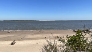
Few Florida shorelines undergo such rapid change as we’ve witnessed along the coastline of Big Talbot Island.
Perpetual erosion of the bluffs by waves and wind off a particularly tempestuous Atlantic north of the St. Johns River continually reshapes the experience of visiting this park.
 Trees are always tumbling off the bluffs
Unlike at the state parks to its north and south, the beach isn’t especially wide. The surface relatively firm, it’s better for walking and beachcombing than sunning.
When we first visited the park for 50 Hikes in North Florida, access to the beach was via a staircase descending from the picnic area.
 Deck where the staircase once descended
Built to keep moving the access points away from the worst erosion, the Shoreline Access Trail winds along the high bluffs above Nassau Sound.
A mile round-trip (or more) to access Boneyard Beach, it passes other abandoned attempts of staircases to the beach repurposed as scenic overlooks.
 Another abandoned access point
Resources



Disclosure: As authors and affiliates, we receive earnings when you buy through our links. This helps us provide public information on this website.
Overview
Location: Big Talbot Island
Length: 1.1 mile round-trip
Trailhead: 30.50234, -81.45016
Address: 15500 Bucaneer Trail, Jacksonville
Fees: $3 per vehicle
Restroom: North along A1A at Sawpit Creek
Land manager: Florida State Parks
Phone: 904-251-2320
Open 8 AM to sundown. Pets permitted on the trail but not on the beach. Swimming is not advised, since currents are strong in Nassau Sound.
Heed warning signs regarding high tide. Check when it will occur and leave the beach before it does so as not to get trapped along it.
Directions
From Jacksonville, drive north via I-295E over the Dames Point Bridge and exit at Heckscher Dr (SR 105). Drive east. After the highway passes the St. Johns River ferry dock 9 miles into the drive, the road becomes A1A. Continue another 9 miles, driving through Little Talbot Island State Park before crossing a bridge to Big Talbot Island State Park. Pass the trailheads for Big Pine Trail and Blackrock Beach. The entrance to Bluffs Picnic Area is the next one on the right.
Hike
From the main parking area, walk around to the beach mat adjoining a kiosk. The mat leads to where the original staircase descending to the shore used to be.
It’s now an observation deck ringed with benches, a fence along the edge of the bluff. Across the sound, the beach at Amelia Island State Park sparkles.
 Picnic grounds on the bluff
The surf where the Nassau River flows into the Atlantic Ocean is a pronounced line on the far right horizon.
Leave the deck and turn right to start along the Shoreline Access Trail. Park signs provide warnings about the tide and park rules.
 Start of the Shoreline Access Trail
Passing a glimpse of the sound and the highway bridge across it, walk a straightaway edged by coastal hammock, a cabbage palm rising tall.
Curve along a ghostly forest battered by salt spray driven ashore by hurricane winds. At the time of our visit, the trees were still standing but as browned as if burnt.
 Ghostly forest
At 0.2 miles, reach the next observation deck where a staircase once descended to the beach.
Flanked by benches, it affords a closer perspective of Amelia Island and the breakers at the mouth of the sound.
 Observation deck
A sign for the trail points into a tunnel of low coastal hammock, a thicket of scrub oaks. Above, sand pines reach for the sky.
As in the ghost forest, most of the tall live oaks show extreme stress, shorn of many of their branches. The shiny leaves of silk bay sparkle in the sun.
 Tunnel of scrub
Southern red cedar joins the thicket of understory forming impenetrable walls under the towering trees.
Emerge onto a rough descent from the forest to Boneyard Beach below. As noted, this may shift closer to the bridge based on erosion.
 Coastal forest
Eroded trees, rootballs and all, litter the brownish sands. Spiky sticks from embedded branches jut out along the water’s edge.
It’s an eerie sight, especially when coupled with the wind- and salt-damaged trees along the bluffs which will soon fall, too.
 Boneyard Beach
Step up to the water’s edge at a half mile. Nassau Sound spreads out ahead, the sweep of beach on Amelia Island on the far shore.
Walk as far as you like in either direction to explore, but mark the spot where the trail emerges so you can find your way back to the trailhead.
 Walking north along the beach
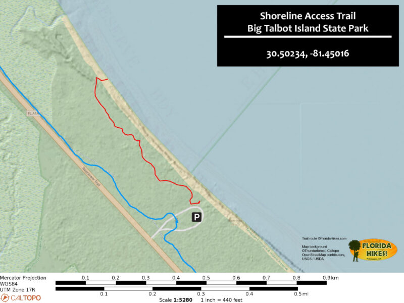
Trail Map
Explore More!
Learn more about Big Talbot Island State Park
 Big Talbot Island State Park Wind and water perpetually reshape the landscape along this rugged Atlantic shoreline with tidal pools, black rock beaches, and a boneyard of sand-scoured trees.
Video
Hiking the Shoreline Access Trail
Slideshow
See our photos from the Shoreline Access Trail
Nearby Adventures
 Timucuan Trail Connecting a series of state parks north of the St. Johns River in Jacksonville, the Timucuan Trail is a delightfully scenic segment of the East Coast Greenway.
 Big Talbot Black Rock Trail An unusual and picturesque geologic anomaly, Blackrock Beach at Big Talbot Island is covered with formations that look like black lava rocks but are made of sand.
 Big Talbot Big Pine Trail The southernmost trail on Big Talbot Island is a short walk out to a bluff above the Simpson Creek estuary through a coastal hammock riffled by breezes.
 Dune Ridge Trail Expect some elevation change along the Atlantic Coast on this traverse of coastal habitats that includes the tall oceanfront dunes and the beach itself.

- Michael Crotty Bicentennial Park - November 3, 2026
- A.J. Henry Park - November 1, 2026
- Okeeheelee Nature Center Trails - October 22, 2026