
One of several conservation properties within 7 Creeks Recreation Area, Cedar Point Preserve hosts a linear section of the 7 Creeks Trail and four side loops.
To thoroughly explore this densely wooded peninsula, the preserve has two access points.
Use the Fitzpatrick Creek Trailhead to access the main trail. The Black Hammock Island Trailhead across Pumpkin Hill Creek also connects to the trails of Timucuan Preserve.
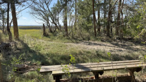
 Bench alongside Pumpkin Hill Creek
Resources





Disclosure: As authors and affiliates, we receive earnings when you buy through our links. This helps us provide public information on this website.
Overview
Location: Jacksonville
Length: 6.5 miles
Trailhead: 30.461972, -81.488556
Address: 7222 Cedar Point Rd, Jacksonville
Fees: Free
Restrooms: Portalet at the trailhead
Land manager: City of Jacksonville
Phone: 904-630-2489
Open sunrise to sunset. Leashed dogs allowed. Trails shared with cyclists and equestrians.
Directions
From the junction of Interstate 295 and Interstate 95 in north Jacksonville, head east on I-295 for 0.7 mile before taking the off ramp onto US 17 heading north. In 0.4 mile, turn right onto New Berlin Rd, continuing for 1.9 miles before taking a right to remain on New Berlin Rd. Stay straight in three miles where Cedar Point Rd begins. Continue along it for 4.6 miles. The parking area for the trailhead is on the right side of the road.
Hike
Beginning at the southeastern corner of the Fitzpatrick Creek Trailhead parking lot, follow the fenceline of a private cemetery for 200 feet.
Come to a large map kiosk designating the start of the trail system. The wide pathway curves sharply to the left, entering a mixed canopy forest of pine and oak.
 Map kiosk
The overstory opens while rounding a bend in a quarter mile, as the trail cuts through a patch of mesic flatwoods alongside a flatwoods lake.
Although the lake is mostly obscured by thick vegetation, nearby cypress trees tell of its proximity to the trail.
At a half mile, another sign indicates a boundary where the trail leaves Pumpkin Hill State Park to enter Cedar Point Preserve.
 Cypress lined lake
As the path sweeps eastward, turn left at the next intersection to begin the Deer Run Trail.
The first of several side loops, this sandy pathway immerses visitors in a shady coastal hammock covered with saw palmettos, lyonia, and live oaks.
 Coastal hammock
Deer Run ends at the main trail in 1.2 miles, where a pair of picnic tables and a bench provide a place to rest near the center of the trail network.
Continue straight across the main trail to begin the Bobcat Loop.
A spur trail extends from this trail, but it can be skipped as the path eventually becomes a confusing bushwhack with no real views of the marsh.
 Picnic spot
Returning to the main trail in a half mile, turn right to start a southerly trek along the Marsh Loop. The loop is roughly one mile including side trips to the marsh.
This path delivers with views of the salt marshes as it leads out onto a peninsula where two spur trails end at scenic overlooks.
 Marsh Loop bench
At the next junction, turn right onto aptly named Bird Pond Trail, a short connector that passes a bench alongside a small body of brackish water that attracts various waterfowl.
In a quarter mile, follow the main trail eastward as oaks give way to pines, taking a right turn at the next spur trail.
It leads along a bluff to a covered picnic table overlooking Pumpkin Hill Creek.
 Bird Pond
Trace the bluff northward for a tenth of a mile to an impressive pedestrian bridge crossing over the creek.
This popular picturesque spot is a great place to take a break and take in the scenery.
 Bench in the middle of the bridge
On the other side of the creek, the 7 Creeks Trail continues eastward into the Cedar Point unit of Timucuan Preserve.
From this point, follow the main trail back towards the trailhead, reaching the Turkey Trot loop in another mile.
 Pumpkin Hill Creek Bridge
Turn left at this junction, traveling through pine forests on a side route for 0.7 mile before returning to the main trail.
A spur trail splits off this loop, offering an additional 0.7 mile round trip to a secluded corner of the salt marshes.
Turning left onto the main trail, follow the markers northward for another 0.8 mile, ending the hike at the trailhead.
 Turkey Trot loop
Trail Map

Explore More!
Learn more about the 7 Creeks Trail
 7 Creeks Trail Venture across scenic coastal landscapes and verdant upland forests on a linear 7.2 mile trail tying together conservation lands on Jacksonville's Northshore.
Video
Hiking Cedar Point Preserve
Nearby Adventures
 Pumpkin Hill Creek Preserve Trails With interconnections to adjoining public lands, the extensive trail network at Pumpkin Hill Creek Preserve State Park connects more than 15 miles of trails to many miles more.
 Betz-Tiger Point Preserve On a peninsula where the Timucua used the surrounding estuary for sustenance, Betz-Tiger Point Preserve provides more than six miles of breezy trails.
 Bogey Creek Preserve A well-interpreted and easy loop hike honors the legacy of a Jacksonville author who left her waterfront homestead for future generations to enjoy.
 Fort George Island Cultural State Park With layer upon layer of human habitation atop the highest natural hill on the southeastern Atlantic Coast, Fort George Island offers a long look at the past.

- Calusa Heritage Trail - November 5, 2026
- Scherer Thaxton Preserve - October 21, 2026
- Little Awesome Preserve - October 19, 2026