
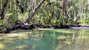
Well hidden amid a dense coastal estuary along the Gulf of Mexico, the crystalline Chassahowitzka River transports visitors to primordial pre-colonial Florida.
The shallow, slow-moving river provides an easy paddle and is a fantastic area to view manatees in winter.
 The clear, spring-fed Chassahowitzka River
Kayaks and canoes are available to rent at the boat ramp, and a small launch fee provides access for those who have their own equipment.
An adjacent campground offers overnight accommodations under a thick canopy of hardwood forest.
But the main reason to paddle the Chassahowitzka, or “Chaz” as it’s known locally, is an abundance of easy-to-reach, showy springs.
 Seven Sisters Spring is one of many along this paddle
Resources




Disclosure: As authors and affiliates, we receive earnings when you buy through our links. This helps us provide public information on this website.
Overview
Location: Homosassa
Length: 3.3 mile round-trip
Launch: 28.714954, -82.577287
Address: 8600 W Miss Maggie Dr, Homosassa
Fees: $5 per vehicle
Restrooms: At the campground store
Land manager: Citrus County / South Florida Water Management District
Phone: 352-382-2200
Parking area open 24 hours. Parking pass must be purchased from the camp store, open 8-6 daily.

Directions
From the intersection of SR 19 with SR 98 south of Homosassa Springs, head west on W Miss Maggie Dr for 1.6 miles. Turn right to remain on W Miss Maggie Dr. The boat ramp is at the end of the road in 0.2 mile.
Paddle
Pushing off from the launch into navy blue-green waters, steer to the right while gliding across a small lagoon often inhabited by manatees.
Meander upstream towards a wide creek. Turbulent ripples on the surface reveal a large underwater boil, the first-magnitude Chassahowitzka Spring.
 Chasshowitzka Spring pool
Continue paddling against the slow current for a few hundred feet to an intersection and turn left.
The water quickly becomes crystal clear, revealing curious circular limestone formations.
Below the surface, a series of cavities known as Seven Sisters Springs emit an azure-tinted flow in this popular swimming spot.
 Limestone formation
Turn back towards the main spring lagoon. A slow downstream drift opens to a wide expanse of the Chassahowitzka River. Float with the current towards the Gulf of Mexico.
A stream to the right leads to a boil known as Crab Creek Spring, an optional side trip. The spring is a tenth of a mile upstream, in front of a large house on the water’s edge.
 Crab Creek Spring
Following the westward flow, continue along the broad waterway for a half mile to Baird Creek.
Ospreys chirp noisily overhead as otters trace the river’s edges, searching for a meal in the shallow waters.
Schools of mullet race below the surface, with an occasional leap followed by a slap as they splash back into the water.
 Open waters of the Chassahowitzka River
Cedar trees arch overhead where you enter Baird Creek on the south side of the river.
This creek is fed by a handful of springs, requiring a steady paddle against the gently flowing run.
Many of these boils are hidden beneath opaque waters, although the picturesque spring at the end is strikingly clear.
 Baird Creek
A thick subtropical forest surrounds the narrow creek lined with tall grasses and cabbage palms. Paddling upstream, the waterway is easily navigable for 0.7 mile.
It becomes calf deep for the final 500 feet of the run. Depending on tide-influenced water levels, the last bit may require wading in the cool, shallow waters.
 Tropical creek run
Two miles into your journey, a pool forms around The Crack at the source of the creek, a long limestone fissure surrounding Baird Spring.
A rope swing dangles from tall tree cover over the center of this remote yet popular swimming hole.
 The Crack
From The Crack, returning to the launch point involves a leisurely paddle down Baird Creek and upstream on the Chassahowitzka River another 1.3 miles.
Kingfishers chatter as they dart down a wild waterway lined with herons, egrets, and anhingas who hold their wings out to dry in the mid-day sun.
 Needlerush lining the creek
Trail Map

Explore More!
Learn more about Chassahowitzka WMA.
 Chassahowitzka WMA Protecting more than 34,000 acres of coastal habitats along Florida's Adventure Coast, Chassahowitzka WMA offers extensive exploration on its network of limerock roads.
Video
Explore the Chassahowitzka River on a recap of this journey
Nearby Adventures
 Paddling the Weeki Wachee River One of Florida's most beautiful paddling trips, the Weeki Wachee River rises from first magnitude Weeki Wachee Springs and winds through lush floodplain forests as it is fed by hundreds of smaller springs along this 5.5-mile paddling run.
 Withlacoochee State Forest With more than 155,000 acres spread over several counties, Withlacoochee State Forest is Florida’s second largest state forest, and arguably the most popular for outdoor recreation
 Homosassa Springs Wildlife State Park A former roadside attraction at the source of the Homosassa River, this Florida State Park showcases native Florida wildlife.
 Crystal River Preserve State Park Crystal River Preserve State Park spans 20 miles of the Gulf Coast between Yankeetown and Homosassa, protecting key manatee habitats along estuaries of the Gulf.

- Calusa Heritage Trail - November 5, 2026
- Scherer Thaxton Preserve - October 21, 2026
- Little Awesome Preserve - October 19, 2026