• Skip to main content
  • Skip to header right navigation
  • Skip to after header navigation
  • Skip to site footer
Florida Hikes logo

Florida Hikes

Hike Bike Paddle Camp Florida with authors Sandra Friend and John Keatley as your guides

  • Trails
  • Maps
  • Guidebooks
  • Hike
    • Scenic Hikes
    • Loop Trails
    • Dog-friendly Hikes
    • Hikes for Kids
    • National Parks in Florida
    • Florida State Parks
  • Bike
    • Major Bike Trails
    • Paved Bike Trails
    • Off Road Biking
    • Biking Articles
  • Paddle
    • Canoe & Kayak Rentals
    • Paddling Destinations
    • Paddling Articles
  • Camp
    • Cabin Rentals
    • Car Camping
    • Primitive Camping
  • Florida Trail
    • Plan your Hike
    • Best Scenic Hikes
    • Best Backpacking
    • Section Hiking
    • Thru-Hiking
    • Trail Updates
  • Travel
Observation deck among mangroves

Leffis Key Preserve

Discover the spectacular beauty of a coastal mangrove forest on a network of boardwalks along Sarasota Bay at the base of a 26-foot-hill with an outstanding view.

Bradenton Beach (27.450817, -82.690650)   0.8 miles   Coquina Baywalk
Jul 2026 update. Still listed as closed on the county website due to hurricane damage.

A spoil island like no other, Leffis Key is a key feature of a conservation area called Coquina Baywalk at the south end of Anna Maria Island, which also encompasses Coquina Beach.

Leffis Key Preserve has blossomed over the past two decades since our first visit. Invasive species were largely rooted out, and native plants now provide deep shade.

Shade surrounding a boardwalk Tree canopy along a boardwalk


From a 26-foot promontory in the center of the island, enjoy a panorama of Sarasota Bay similar to what ancient civilizations here saw from their temple mounds.

Trails crisscross this crest, connecting with a circular path at the base of the man-made hill. Radiating from that path, boardwalks lead to observation decks at water level.

Shaded picnic bench with a view One of the views from the high point


Resources

Resources for exploring the area
South Florida Explorers Guide book cover Hikers Guide to the Sunshine State book cover Paddlers Guide Florida 50 Hikes in South Florida book cover Hiking the Gulf Coast book cover
 
Disclosure: As authors and affiliates, we receive earnings when you buy through our links. This helps us provide public information on this website.

Overview

Location: Anna Maria Island
Length: 0.8 mile loop
Trailhead: 27.450817, -82.690650
Address: 2351 Gulf Dr S, Anna Maria Island
Fees: Free
Restroom: At Coquina Beach
Land manager: Manatee County
Phone: 941-748-4501

Open 8 AM to sunset. No dogs permitted. A bike rack is provided for cyclists. Mosquitoes can be intense here; prepare for them before you start your hike.

A large picnic pavilion adjoins one corner of the parking area. Restrooms are across Gulf Drive at Coquina Beach, which can be tough to cross.

Fishing is allowed from boardwalks with a Florida fishing license. Please do not ride bicycles on boardwalks or up the hill.


Directions


From US 41 (9th St SW) in downtown Bradenton, follow Manatee Ave (SR 64) west 4 miles to 75th St SW. Turn left and continue 2.3 miles to Cortez Rd (SR 684). Turn right and follow Cortez Rd 4 miles to Anna Maria Island. Turn left on Gulf Dr (SR 789). 1.1 miles south of the roundabout at Bridge St in Bradenton Beach, use the turnout on the left in front of Coquina Beach for Leffis Key Preserve.

Hike

Start next to the preserve sign in the parking area. The broad access path leads between walls of mangroves and sea grapes to a bridge over a flowing channel.

Cross the bridge to meet a trail junction in front of a bench. Bear right. Just before the next bench, a boardwalk tempts to the right.

Broad shell path to bridge Entrance path


Zigzagging through a mangrove tunnel — a reoccurring theme on this hike — the boardwalk crosses the channel that flowed under the first bridge.

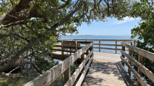
The channel empties out into Upper Sarasota Bay, where the boardwalk emerges from the mangroves to provide an outstanding view from a large observation deck.

Aquamarine water with islands and mangroves Sarasota Bay


Return along the boardwalk, pausing to inspect the trunks of the mangroves for mangrove crabs, and turn right in front of the bench.

A fork in the trail lies ahead. Take the one to the left, which leads uphill past an interpretive sign about the coastal ridge habitat.

Interpretive sign next to sloped trail Start of the climb


It’s a gradual ascent but noticeable, with water bars to keep the crushed shell trail from washing away.

Leveling off, the path reveals a chickee-topped picnic bench. That’s the high point, so continue uphill to savor the view.

View beyond picnic table View towards Upper Sarasota Bay


A second path leads to a similar bench with a view south across the bay, although it’s not as showy.

Three walkways descend from this promontory. Backtrack towards the one you climbed up here and take the natural surface path next to it.

Winding path downhill through tropical trees Descending from the hilltop


It makes a gentle descent through the coastal hammock, coming to a T intersection with the broad loop around the island. Turn right.

Along this mangrove-edged corridor, the top of the hill is visible briefly just before a boardwalk at 0.3 mile. Turn left.

End of boardwalk peeking out of vegetation Boardwalk off the main loop


Crossing a scrim of mangroves along the edge of the spoil island, it deposits the trail onto a shell berm passing a bench.

Another boardwalk begins, simply providing elevation over the surrounding salt flats. It meets another shell berm and resumes.

Low boardwalk with no railings Salt flat boardwalk


Pass an interpretive sign after this boardwalk ends, confirming the surrounding habitat. A new low boardwalk leads into the mangroves.

Come to a three way intersection of boardwalks inside the mangrove forest and proceed straight ahead to the near overlook.

Tunnel of mangroves with blue sky beyond boardwalk The light at the end of the tunnel is Sarasota Bay


It’s obvious in contrast to the first observation deck this one faces east, with a nice sweep of bay and channel at your feet.

Turn around and turn right to follow the boardwalk to the northernmost observation deck, facing the distant bridges to the mainland.

Octagonal deck framed by mangroves Northernmost view


Backtrack to the three-way junction to follow the boardwalk straight ahead. The boardwalk, however, is anything but straight.

It meanders and curves through the mangroves, briefly depositing the trail on not-so-dry ground for a few strides through the tidal marsh past an interpretive sign.

Boardwalk in mangroves Boardwalk ascending from the tidal marsh


Curving beneath the mangroves, note the shallowness of the water under the prop roots of the red mangroves and the bed of fallen leaves on the bottom.

Mangrove forests along bayfront islands serve as aquatic nurseries, protection for the young fry from predators in open waters.

Prop roots above shallows Mangrove nursery


At a half mile, follow a spur boardwalk out to the edge of the bay for another broad perspective on the main channel and islands to the south.

Return through the tangled forest of prop foots and pass an interpretive sign about this tangled forest. The boardwalk zigzags past a high marsh, a good spot for birding.

Open salt water marsh bordered by mangroves High marsh


Soon after, the boardwalk ends at the island loop. Make a left and walk past a bench. Within view of the ascent trail to the high point, another boardwalk tempts.

Turn left to follow its sharp angles out to the bay. It has a little niche over a tidal creek before it ends at the final observation deck.

Observation deck on bayfront Last perspective on Sarasota Bay


In addition to the sweeping view of the bay, Longboat Pass between Anna Maria Island and Longboat Key is visible to the southwest.

Inspect the shallows here for more aquatic life in miniature: tiny crabs, fingerling fish, and itty bitty sting rays. Return along the boardwalk.

Mangrove shallows Shallow waters along the island’s edge


Turn left and continue past the ascent to the promontory to complete your circuit of the island.

Pass by the initial boardwalk you explored, and through the three-way junction at the bridge. Proceed straight ahead to exit to the parking area, completing this 0.8 mile hike.

Bridge in front of trail junction To exit, continue across the bridge at the final junction


Trail Map

Leffis Key Preserve Trail Map


Explore More!

Video

A walk through Leffis Key Preserve


Slideshow

See our photos from Leffis Key Preserve


Nearby Adventures

Boardwalk through mangroves Joan M. Durante Community Park A bayfront park on Longboat Key with boardwalks meandering through mangrove forests plus wide shell paths traversing a native upland hammock.
Observation tower on a lagoon Robinson Preserve Edging Tampa Bay, the vast sweep of Robinson Preserve is a puzzle of natural and restored habitats circled by more than ten miles of mixed-use trails.

Official Website

  • Author
  • Recent Posts
Sandra Friend
Sandra Friend
Author of 45 books, Sandra Friend established FloridaHikes.com in 2006 to expand on the field research she'd completed for her first six hiking guides. She has been honored with lifetime achievement awards from the Florida Trail Association and the Florida Outdoor Writers Association.
Sandra Friend
Latest posts by Sandra Friend (see all)
  • Michael Crotty Bicentennial Park - November 3, 2026
  • A.J. Henry Park - November 1, 2026
  • Okeeheelee Nature Center Trails - October 22, 2026
Category: Hikes, Natural Lands, Nature Trails, Southwest Florida, TrailsTag: Accessible, Bradenton, Bradenton Beach, Family-Friendly, Fishing, Mangroves, Observation Decks, Sarasota, Scenic Hikes

Sidebar

FarOut Guides

Our comprehensive trail logistics presented on offline maps:

Florida National Scenic Trail (1,500 miles)
Florida Keys Overseas Heritage Trail (108 miles)
Eastern Continental Trail in Florida (92 miles)


We earn a small commission on sales through these links. Thanks for your support!


Our Guidebooks

We’ve written Florida guidebooks for over 25 years. These include Southwest Florida destinations.

Book cover with woman hiking through palms with baby carrier
Book cover of Florida Trail Hikes
The Florida Trail Guide fifth edition

Explore More

Newest Articles for Southwest Florida

Showy cloudscape beyond a sand road in scrub Oscar Scherer Green Trail
View of open water framed by trees Calusa Heritage Trail
Footpath dipping into dampness amid mangroves Nancy Weir Mangrove Preserve
Firebreak and grassy strip through pine flatwoods Scherer Thaxton Preserve

  • Facebook
  • Flickr
  • Instagram
  • Pinterest
  • Substack
  • Vimeo

FIND A TRAIL OR PARK

METROS: Bradenton. Clearwater. Crestview. Daytona Beach. Destin. Fort Lauderdale. Fort Myers. Fort Walton Beach. Gainesville. Jacksonville. Kissimmee. Lakeland. Melbourne. Miami. Naples. Ocala. Orlando. Panama City Beach. Pensacola. Port St. Lucie. Punta Gorda. St. Petersburg. Sanford. Sarasota. Sebring. Stuart. Tallahassee. Tampa. Vero Beach. West Palm Beach.

MULTI-REGION: Atlantic Coastal Ridge. Atlantic Coast. Bartram Trail. Big Bend. East Coast Greenway. Everglades National Park. Florida National Scenic Trail. Gulf Coast. Lake Wales Ridge. WATERWAYS: Indian River Lagoon. Intracoastal Waterway. Kissimmee River. St. Johns River. Withlacoochee River.

NORTHWEST FLORIDA: Altha. Apalachicola. Apalachicola National Forest. Big Bend Scenic Byway. Blackwater River State Forest. Blountstown. Bonifay. Bristol. Bruce. Cantonment. Cape San Blas. Carrabelle. Chattahoochee. Chipley. Crawfordville. DeFuniak Springs. Eastpoint. Ebro. Eglin Air Force Base. Freeport. Fountain. Gulf Breeze. Gulf Islands National Seashore. Holt. Madison. Marianna. Milton. Monticello. Mossy Head. Munson. Navarre. Navarre Beach. Newport. Niceville. Panacea. Panama City . Perdido Key. Ponce De Leon. Port St. Joe. Quincy. Santa Rosa Beach. Sopchoppy. South Walton. St. George Island. St. Marks. St. Marks NWR. Sumatra. Vernon. Wakulla. Wewahitchka. Woodville. WATERWAYS: Apalachicola River. Blackwater Bay. Blackwater River. Chipola River. Choctawhatchee Bay. Choctawhatchee River. Coastal Dune Lakes. Ochlockonee Bay. Perdido River. St. Marks River. Wacissa River. Wakulla River. Yellow River.

NORTH FLORIDA: Alachua. Amelia Island. Archer. Baldwin. Branford. Bronson. Bunnell. Callahan. Cedar Key. Chiefland. Crescent City. Cross City. Cross Creek. Dowling Park. Ellaville. Fanning Springs. Fernandina Beach. Flagler Beach. Fort White. Glen St. Mary. Green Cove Springs. Hawthorne. High Springs. Inglis. Jacksonville Beaches. Jacksonville Northshore. Jasper. Jennings. Keystone Heights. Lake Butler. Lake City. Live Oak.Macclenny. Mandarin. Mayo. Mayport. Micanopy. Middleburg. Old Town. Olustee. Orange Park. Osceola National Forest. Palatka. Palatka-Lake Butler Trail. Palm Coast. Palm Valley. Perry. Ponte Vedra. Rodman. Salt Springs. St. Augustine. Starke. Steinhatchee. Suwannee. Suwannee River Wilderness Trail. Suwannee Springs. Talbot Islands. Timucuan Preserve. Trenton. Waldo. Welaka. White Springs. Williston. Worthington Springs. Yankeetown. WATERWAYS: Santa Fe River. St. Marys River. Suwannee River. Tolomato River. Upper Withlacoochee River.

CENTRAL FLORIDA: Altamonte Springs. Apollo Beach. Apopka. Astatula. Astor. Auburndale. Bartow. Babson Park. Bayport. Belleview. Bithlo. Brandon. Brooksville. Bushnell. Canaveral National Seashore. Cassadaga. Christmas. Chuluota. Citrus Springs. Clearwater Beach. Clermont. Coast to Coast Trail. Cocoa. Cocoa Beach. Cross Florida Greenway. Crystal River. Dade City. De Leon Springs. DeBary. Deland. Deltona. Dunedin. Dunnellon. Edgewater. Enterprise. Eustis. Ferndale. Fort Meade. Frostproof. Geneva. Gibsonton. Haines City. Hernando. Hernando Beach. Holopaw. Homosassa. Inverness. Kenansville. Kissimmee. Lake Mary. Lake Wales. Largo. Leesburg. Lithia. Longwood. Lutz. Maitland. Malabar. McIntosh. Melbourne Beach. Merritt Island. Merritt Island NWR. Mims. Mount Dora. Narcoossee/Lake Nona. New Port Richey. New Smyrna Beach. Nobleton. Oak Hill. Oakland. Ocala National Forest. Ocklawaha. Ocoee. Oldsmar. Orange City. Ormond Beach. Osteen. Oviedo. Paisley. Palm Bay. Plant City. Poinciana. Polk City. Ponce Inlet. Port Orange. Ridge Manor. Riverview. Ruskin. Safety Harbor. Silver Springs. Sorrento. Spring Hill. St. Cloud. Tarpon Springs. Thonotosassa. Titusville . Umatilla. Viera. Walt Disney World. Weeki Wachee. Weirsdale. Wimauma. Windermere. Winter Garden. Winter Haven. Winter Park. Winter Springs. Withlacoochee State Forest. Withlacoochee State Trail. Yeehaw Junction. Zephyrhills. WATERWAYS: Alafia River. Halifax River. Hillsborough River. Lake Apopka. Little Manatee River. Ochlawaha River. Rainbow River. Tampa Bay. Wekiva River. Wekiva River Basin.

SOUTHWEST FLORIDA: Alva. Boca Grande. Cape Coral. Charlotte Harbor. Ding Darling NWR. Ellenton. Englewood. Estero. Immokalee. Marco Island. North Port. Osprey. Palma Sola. Palmetto. Pine Island. Port Charlotte. Sanibel Island. Venice. WATERWAYS: Caloosahatchee River. Manatee River. Myakka River. Pine Island Sound.

SOUTH FLORIDA: Arcadia. Basinger. Big Cypress National Preserve. Big Cypress Seminole Reservation. Big Cypress Swamp. Bowling Green. Clewiston. Everglades City. Indiantown. LaBelle. Lake Okeechobee Scenic Trail. Lake Placid. Lakeport. Moore Haven. Okeechobee. Ortona. Pahokee. Palmdale. Port Mayaca. South Bay. Wauchula. Zolfo Springs. WATERWAYS: Fisheating Creek. Lake Okeechobee. Peace River.

SOUTHEAST FLORIDA: Biscayne Bay. Biscayne National Park. Boca Raton. Boynton Beach. Coconut Creek. Coral Gables. Coral Springs. Davie. Delray Beach. Fellsmere. Flamingo. Fort Pierce. Hobe Sound. Hollywood. Homestead. Indrio. Jensen Beach. Juno Beach. Jupiter. Jupiter Farms. Key Biscayne. North Hutchison Island. Ocean to Lake Greenway. Palm Beach. Palm Beach Gardens. Pompano Beach. Redland. Sebastian. South Hutchinson Island. WATERWAYS: Florida Bay. St. Lucie River.

FLORIDA KEYS: Big Pine Key. Islamorada. Key Largo. Key West. Marathon. Overseas Heritage Trail.


©2006-2026, Sandra Friend & John Keatley | Disclosure | Site Index | Work with Us | Advertise with Us | Terms of Service and Privacy Policy

Florida Hikes PO Box 93 Mims FL 32754 | Contact
