
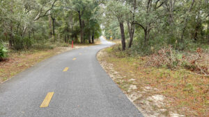
Winding through a forested setting for almost sixteen miles, this multi-use paved trail illustrates the terrain of the Ocala Highlands.
Running down the center of North Central Florida, this rocky ridge is known for its caves, sinkholes, and boulders. Undulating hills mean steady climbs and descents.
 Ascending a series of hills
Centrally located in the footprint of what was once to be the Cross Florida Barge Canal, it crisscrosses many other recreational trails.
Among them are singletrack, equestrian trails, carriage trails, and the statewide Florida National Scenic Trail, all sharing the Land Bridge over Interstate 75.
 Colored posts mark adjoining and cross trails
Our journey begins at Santos, home to Santos Campground, at a trailhead shared with the Florida Trail and the destination-worthy offroad Santos Trails.
The pavement presently ends within earshot of SR 200, a turnaround point as no trailhead is nearby. In the future, the trail will extend to Dunnellon.
 Pleasant spot for a break
Resources





Disclosure: As authors and affiliates, we receive earnings when you buy through our links. This helps us provide public information on this website.
Overview
Location: Ocala
Length: 15.6 miles
Trailhead: 29.105647, -82.094408
Address: 3080 SE 80th St, Ocala
Fees: Free
Restroom: At the trailhead
Land Manager: Florida State Parks
Phone: 352-236-7143
Open 8 AM to sunset. Leashed dogs welcome. Reserve camping at Santos or Shangri-La in advance.
Directions
From Interstate 75 exit 341 (Belleview / Dunnellon), follow SR 484 east to the traffic light and turn left onto CR 475A (SW 16th Ave). Drive 2.8 miles north, passing the Land Bridge trailhead before turning right onto CR 475B (SW 107th Pl). This ends at a T after 1.1 miles. Make a left on CR 475 (Magnolia Ave). Continue north 2.8 miles to the light at SE 80th Ave. Turn right and drive 2.6 miles. The entrance is well marked on the right, just past the “Santos Trails” entrance for offroad cyclists. Park near the restrooms.
Trail Details
The paved path begins adjacent to the restrooms at the original Santos trailhead adjoining the campground.
A connector to the Florida Trail takes off into the forest on the left. A sidewalk coming in from the right brings in traffic from the larger Santos Trails trailhead.
 Starting point at Santos
From the start of the trail to the first road crossing two miles ahead, expect to encounter many walkers and families with children on bikes, even on weekdays.
Curving through a mature sandhill forest, pass an interpretive sign about gopher tortoises on a steady downhill.
 First Florida Trail crossing
A crosswalk marks where the hiking-only Florida Trail bisects the path at the start of a curve. Many more crosswalks are ahead.
The broader striped crosswalks are horse-and-carriage crossings. The paved path was laid atop a limestone road used for land management and emergency access.
 Diamond markers are for horse trails
The steady downhill trend continues beneath tall pines and oaks. In winter, the orange blazes of the Florida Trail are obvious on trees to the right.
At a crosswalk adjoining a picnic table, cross a spur of the singletrack Pine Tree Trail headed east to the Santos Bike Shop.
 Steady downhill
Beyond several equestrian and carriage trail crossings in the piney woods, a sign at 1.4 miles calls attention to the Whimcycle Trail.
Heading east, that short singletrack leads to a campground with cabins. Past it, keep gently descending under the pines.
 Whim Cycle turnoff
Reach a broad striped crosswalk with a collection of road signs visible ahead. Stop for this road crossing at SE 25th Ave.
It’s a narrow canopied road in Belleview and vehicles barrel down it well above the speed limit.
 SE 25th Ave
An open area beyond the trees is an old pasture. Near it, the remains of a former building crumble beneath a load of vines.
The forest is largely older laurel oaks, a common sight around Ocala where pastures have been abandoned.
Unlike the more stately live oaks, laurel oaks grow quickly and taller but lead shorter lives, dropping a lot of branches when shaken by the wind.
 Amid the laurel oaks
The shiny leaves of southern magnolias stand out in the understory. Pass a trailside picnic bench at 1.9 miles. The downhill continues.
Fern-covered boulders adjoin the road crossing at SE 95th St a quarter mile later. It’s not a busy road but drivers do not stop to let you cross. Stop and look.
 SE 95th St
Thankfully, there are no more road crossings after this. Instead, tunnels and a bridge carry trail users across and under busy highways.
Inside the fence, an old pasture was planted in pines, an equestrian trail leading through it.
 Woodland meanders
Begin a mild uphill past a picnic bench at 2.5 miles, cresting before a steady downhill.
Just beyond a trail crossing for the Florida Trail, flow through a curve past a picnic bench adjoined by a limestone cairn.
 Cairn
On a bike, it’s easy to pick up speed through this section, but there are many crosswalks marking cross trails.
Occasional signs point out what they are, such as the one to the Spider Kingdom singletrack area at 4.6 miles.
The orange-blazed Florida Trail cross the path again. Completed in 1999, it’s the oldest of the greenway trails.
 A steady downhill
The steady downhill becomes more sharp, accompanied with a speed limit warning as the path makes a sharp curve.
Continue through an underpass beneath CR 475. The curve turns sharply on the opposite side. Leveling out in a meadow, it draws next to a fence.
 Underpass for CR 475
Follow the edge of a large equestrian complex, the Florida Horse Park. The next sharp turn signals the lead-in to a descent to an underpass beneath CR 475A.
This is a near-horseshoe of a curve whipping by an access point to a network of singletrack trails extending west.
 Florida Horse Park
At 6.3 miles, an incoming paved path joins in from the Land Bridge trailhead at a T intersection.
One of the largest trailheads along the greenway, it has restrooms and a water fountain at its picnic area.
Turn left to stay on the main path. This forest is older and denser, with many live oaks.
 A little west of the T junction
All of the trails join together to cross the Land Bridge over Interstate 75 at 7.4 miles.
Dedicated National Trails Day 2000, it was the first built in the US: a giant planter of filled with rocks and dirt and native trees, suspended over a major highway.
 Atop the Land Bridge eastbound
Besides trail users, wildlife started crossing it. Paving this path across it radically changed its character.
A slender unpaved strip adjoins for equestrians, who also have a horse trough handy on the opposite side.
Descending with a left turn towards a not-so-natural bowl in the pine forest, the paved path enters “the diggings.”
 The eastbound approach to the Land Bridge
These were the first of a series of excavations started in the 1930s to create a canal across the Florida peninsula.
A centuries-old idea, it took root during a federal infusion of cash during the Depression via the Works Progress Administration.
This particular excavation in a scrub forest was hand-dug and resulted in a massive “sand dune” visible to the left. It’s worth a stop to walk up.
 Sand pine scrub west of the diggings
Climbing out of the otherwise imperceptible excavation, remain in a scrub forest where gopher tortoises thrive. The rare endemic Florida scrub-jay has also been sighted here.
Cross the Florida Trail twice more before reaching an intersection with a paved side path leading to the SW 49th Ave trailhead at 9.7 miles.
 Downhill to SW 49th Ave
The trailhead has portable toilets and a water-bottle filling station. Past that turnoff, all trails meet again on a steep slope for the SW 49th Ave underpass.
On the uphill, the Florida Trail and Trail 1 veer off to the right. At the crest, the equestrian trail heads into the woods on the left.
 Sweeping into the sandhills
Orange blazes parallel the path briefly as the path winds into restored sandhill habitat. Trail 1 crosses at a crosswalk.
Road noise quickly abates as a straightaway yields to a gentle curve. Immersing in nature, keep alert for wildlife. We’ve seen fox squirrels and flocks of wild turkey along this stretch.
 Florida Trail crossing
Orange blazes on the right hail the approach of the Florida Trail at a crosswalk at 10.8 miles. Curve right, noting the open understory that stretches into the distance.
Now edging oaks on the left, pass an orange marker for an equestrian trail that veers onto a fireline. Soon after is a crosswalk for the Nayls North bike trail.
 Nayls North
Curve past a bench. In the woods on the left, steep inclines become obvious. These are the remnants of dirt piles from the digging of the Cross Florida Barge Canal.
They date back to the 1930s, slopes now covered in forest. Laurel oaks infilitrate the sandhills on the curve past a broad grassy trail to the left.
 Bend past a grassy trail
Continue past a bench around a gentle bend, and the sandhills open up again on the right.
The next crosswalk is the Florida Trail again at 12.8 miles. A broader outlined crosswalk past it is the access trail to Shangri-La Trailhead, 0.9 miles southeast.
It’s natural surface but hard packed, leading to restrooms and a campground.
 Shangri-La crossing
Climb a moderate summit to the sound of traffic noise at the approach to the CR 484 underpass.
At the Nayls Trail sign, all trails merge in to join this paved path. Take a steep plunge beneath the highway with a sharp left into the climb on the other side.
 Descent to SR 484 underpass
Reach the covered bench at 13.2 miles. All unpaved routes again diverge from the paved path.
Thanks to not-so-gently rolling hills, this final segment to Ross Prairie is tough on a bike. Curve left past an incoming path from a walk-through access off CR 484.
The broader profile of the pavement marks where the terrain tips sharply uphill.
 Start of the ascent
Flattening slightly at a crest, the trail keeps climbing into sand pine scrub. Continue climbing into sandhills with moderate zigzags.
Gentle curves help hide the relentless uphill. At a grassy spot, a two-track vanishes northward from a crest.
Keep climbing the curves, staying alert for cyclists whizzing downhill.
 Heading for a crest
Reach a straightaway into an even steeper grade, the pavement broadening as if to indicate a passing zone.
After this crest, relax into an enjoyable downhill through scrubby flatwoods. Round several curves before a steep incline over a ridge topped in pines.
 Descent from the ridge
Race downhill, using your momentum for the next moderate climb. The surrounding forest becomes denser. Keep climbing.
Reach marked trail crossings for equestrian trails flanking the Beyond West mountain bike trail. White-tailed deer tend to browse this area.
 Descent towards the last set of trail crossings
A final moderate downhill brings the trail to its current conclusion, a this circle in front of a picnic bench. There is no paved access to parking at this end of the bike path.
Traffic on SR 200 is visible ahead where the Florida Trail crosses the highway. Parking isn’t permitted along that road shoulder, however.
This is the turnaround point at 15.6 miles. Fortunately, you’ve already tackled the steepest grades on this final stretch.
 Turnaround point facing SR 200
If you’ve hiked this rather than biked it, stage a car for a linear walk. Ross Prairie Trailhead isn’t far via the east side of the Ross Prairie Loop.
If on foot on a round-trip, the primitive Ross Prairie campsite is nearby along the Florida Trail. Use the FT as a return route to Santos.
Returning by bike is easier eastbound but still challenging in a couple of spots.
Depending on your start point, it’s a 11.7 mile round-trip from SW 49th Ave, 18.4 miles from Land Bridge trailhead, or 31.2 miles for the full round-trip from Santos trailhead.
 We’ve ridden this several times since it first opened
Trail Map

Explore More!
Learn more about the Cross Florida Greenway
 Cross Florida Greenway Spanning 110 miles between the St. Johns River near Palatka and the Gulf of Mexico, the Marjorie Harris Carr Cross Florida Greenway is a mile-wide recreational corridor.
Slideshow
See our photos from this trail
Nearby Adventures
 Florida Trail, Land Bridge Trailhead to Santos 6.7 miles. Between the Land Bridge Trailhead and Santos, the Florida Trail winds its way around horse farms to meander through stands of oaks and pines.
 Florida Trail, SW 49th to Land Bridge Trailhead 3.6 miles. Bookended by soft sand pines and ancient oaks, this particularly fascinating hike along the Cross Florida Greenway includes a massive dune-like slope and the Land Bridge over Interstate 75.
 Florida Trail, Ross Prairie to SW 49th Ave 6.5 miles. With hilly terrain, fern-covered boulders, and large sinkholes beneath the pines, this is a rugged and interesting segment of the Florida Trail on the Cross Florida Greenway.
 Florida Trail, Pruitt to Ross Prairie 7.5 miles. With switchbacks, scrambles, and ancient oaks, the Pruitt section of the Florida Trail along the Cross Florida Greenway offers a fascinating hike into the history of the Cross Florida Ship Canal.

- Hal Scott Yellow Trail - November 3, 2026
- Hal Scott Preserve - October 28, 2026
- Tradewinds Park - October 27, 2026