
Accessed through Spruce Creek Park in the middle of the Spruce Creek basin bridged by US 1, the Rose Bay Trail has an inviting boardwalk entrance.
Optimized as an outdoor classroom, the largely linear trail sticks close to the creek, leading to an observation tower and two picnic areas amid the cedars and pines.
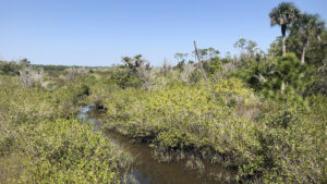
 View of Spruce Creek from the Observation Tower
Resources





Disclosure: As authors and affiliates, we receive earnings when you buy through our links. This helps us provide public information on this website.
Overview
Location: Port Orange
Length: 1.9 miles
Trailhead: 29.09489, -80.97202
Address: 6250 Ridgewood Ave, Port Orange
Fees: Free
Restroom: At the trailhead picnic pavilion
Land manager: Volusia County
Phone: 386-322-5133
Open sunrise to sunset. Leashed dogs welcome. Mosquito repellent a must.
While bog boardwalks have made going to the tower easier, pathways may be muddy or flooded during high tides and after heavy rains.
Directions
From New Smyrna Beach, follow US 1 north past the airport into the Spruce Creek basin. Watch for a turnout at the sign on the west side of the highway for Spruce Creek Park. Once inside the gates, make the second right to park near the picnic pavilion and environmental center.
Hike
Walk around the picnic pavilion to the boardwalk entry point adjoining the playground. This short span leads to a graded path.
Turn right to continue towards the sturdy span connecting this island in the estuary with the next one, which is wholly inside Doris Leeper Spruce Creek Preserve.
 Boardwalk to the Rose Bay Trail
Look down into the tidal waterway and out towards the horizon, where Spruce Creek itself is sometimes visible as a thin line.
A bench in the middle of the boardwalk offers a sunny perch for birding.
 Tidal waterway
The boardwalk ends on an island of pines, cedar, and cabbage palms, a sign providing background on the Rose Bay Legacy Project.
Follow the path under the trees along the edge of the island. Bog boardwalks have been added, but spots without them may be squishy after rains and at high tide.
 Bog boardwalk
A waterway flows beneath a wooden bridge. Spiky-looking yaupon holly grows thickly throughout the understory.
Make a sharp left under towering slash pines. Edging a brackish marsh, keep alert for sunning alligators and snakes. Roots and muck make for slippery going.
 Brackish marsh
The next bridge crosses the outflow of the marsh. Enter a palm hammock, its open understory affording glimpses of the estuary beyond.
Rounding a bend, the observation tower comes into view at a quarter mile.
 Observation Tower
Climb to the top to savor the panorama. Spruce Creek winds through a sea of needlerush marsh in the basin below.
With a roof, the tower affords shelter from the sun and with its height, breezes to keep the mosquitoes at bay.
 View from the tower
From the base of the tower, two roads diverge. Take the one on the right since the one closer to the marsh is more likely to flood.
They rejoin to enter a shady tropical glade where giant leather fern peeks out from behind a picnic bench.
 Road along the estuary
The benches that line this part of the trail are used for the outdoor classroom. Estuary views fade as the saw palmetto understory grows thicker.
The path proceeds through a coastal hammock, sand live oaks forming a canopy above. Salt breezes tickle the senses.
 Picnic tables in the hammock
At 0.7 miles, meet a T intersection with an access road from US 1. Turn left. The road leads into a beautiful palm hammock adjoining Rose Bay.
A picnic pavilion and picnic tables occupy a large clearing. Small breaks in the mangroves along the bay enable views.
 Rose Bay
Trail’s end is a bit surprising, as it simply peters out in an expanse of mud flats surrounded by mangroves.
Wander as far along the road as you feel comfortable to immerse in this unusual habitat, where thousands of mangrove shoots are taking root in the mud.
 Mangrove flats
Someday, it will be a mangrove forest. When we visited there was a still a gap upstream with views of Spruce Creek to the north.
Turn around and retrace your journey. Stop at the tower again if you like. Returning across the boardwalk to Spruce Creek Park, consider a walk around it as well.
 Spruce Creek Park Buffered by Doris Leeper Spruce Creek Preserve, this island along US 1 features easy access to the Rose Bay Trail and its own loop with waterfront views.
It’s a half mile round-trip from the parking area to the tower, a 1.9 mile round-trip to trail’s end at the mangrove flats, and 2.7 miles if you circle Spruce Creek Park, too.
 A last look at the pine forest from the tower
Trail Map

Explore More!
Learn more about Doris Leeper Spruce Creek Preserve
 Doris Leeper Spruce Creek Preserve Protecting miles of frontage along the sinuous path of Spruce Creek, Doris Leeper Spruce Creek Preserve offers a diverse collection of trails to explore.
Slideshow
See our photos from Rose Bay
Nearby Adventures
 Doris Leeper Kaye Access to Bluffs Explore a truly scenic corner of massive Doris Leeper Spruce Creek Preserve on a trio of loops extending 3.6 miles from ancient oak hammocks to high bluffs above the creek.
 Smyrna Dunes Park At Smyrna Dunes Park, this 2.4-mile hike scenic coastal hike is largely along an accessible boardwalk, with side trips off to the sea and inlet via more rugged approaches.
 Sugar Mill Ruins Park At Sugar Mill Ruins Park in New Smyrna Beach, an interpretive trail tells the story of the Cruger-dePeyster Sugar Mill, established in 1830 and abandoned in 1835 after a Seminole raid.
 East Central Regional Rail Trail Spanning 36.2 linear miles across southern Volusia County, the East Central Regional Rail Trail offers a long ride that also makes up a portion of several major Florida bike trails.

- Hal Scott Yellow Trail - November 3, 2026
- Hal Scott Preserve - October 28, 2026
- Tradewinds Park - October 27, 2026