• Skip to main content
  • Skip to header right navigation
  • Skip to after header navigation
  • Skip to site footer
Florida Hikes logo

Florida Hikes

Hike Bike Paddle Camp Florida with authors Sandra Friend and John Keatley as your guides

  • Trails
  • Maps
  • Guidebooks
  • Hike
    • Scenic Hikes
    • Loop Trails
    • Dog-friendly Hikes
    • Hikes for Kids
    • National Parks in Florida
    • Florida State Parks
  • Bike
    • Major Bike Trails
    • Paved Bike Trails
    • Off Road Biking
    • Biking Articles
  • Paddle
    • Canoe & Kayak Rentals
    • Paddling Destinations
    • Paddling Articles
  • Camp
    • Cabin Rentals
    • Car Camping
    • Primitive Camping
  • Florida Trail
    • Plan your Hike
    • Best Scenic Hikes
    • Best Backpacking
    • Section Hiking
    • Thru-Hiking
    • Trail Updates
  • Travel
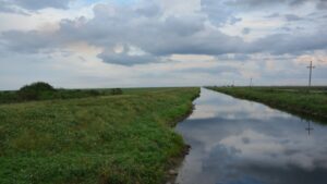
Florida Trail along a canal south of Clewiston

Florida Trail, Seminole

Stretching 56.2 miles from the Big Cypress Seminole Reservation to Lake Okeechobee, the Seminole section crosses a vast agricultural region, with hiking on roads and levees.

Big Cypress Seminole Reservation to Clewiston (26.256229, -81.086823)   56.2 miles   Florida National Scenic Trail

56.2 miles. Encompassing both the Big Cypress Seminole Reservation and a network of levees through vast agricultural lands south of Lake Okeechobee, this region is a study in contrasts to the natural habitats of the Big Cypress Swamp.

Established in the 1940s, the reservation formalized the residences which the Seminole had within the Big Cypress for more than a century.

The Florida Trail follows established roads and adjoining pathways past working cattle ranches, orange groves, a cultural history museum, and the renowned rodeo grounds.

North of the reservation, the hike is through a landscape forever altered. Once the Everglades, a vast sweep of sawgrass prairies, tree islands, and pond apple thickets, it was dynamited, dredged, and diked starting in 1909.

Now it is given over to agriculture, primarily sugar cane fields. It’s a man-made expanse similar in nature to the Midwestern prairies turned to cornfields, except the levees provide panoramic expanses of ranches and fields.

Only Rotenberger WMA at the Deerfence Canal provides a peek into how rich with birds and wildlife the region once was.

Some hikers complain that this section is one long roadwalk. You will walk beside roads and atop levees for the entirety of this section of trail. The Seminole section is a cultural immersion rather than a natural one.


Our Florida Trail Books & Guides

Florida Trail Hikes book cover The Florida Trail Guide book cover Florida Trail history book Florida Trail small coffee table book
 
Disclosure: As authors and affiliates, we receive earnings when you buy these through our links. This helps us provide public information on this website.


Hiking Tips

To hike across the Big Cypress Seminole Reservation, you must fill out and file a “hold harmless” form provided by the Seminole Tribe of Florida. Download and fill out this form in advance of your hike. It must be sent to the Seminole Tribe of Florida. Keep a copy of it with you when hiking.

Never camp on top of the levees. Trucks drive down them at all hours.

While walking past sugar cane fields, you may see plumes of smoke, fire, and ash. Sugar cane is burned right before harvesting to minimize the amount of plant matter collected. Avoid camping next to sugar cane that is in flower, as burns occur 24/7.

Alligators are common in the canals. If you do need to filter water, don’t do so at dawn or dusk, when you might be mistaken for a deer. Avoid filtering water near culverts as well, since alligators often den inside them.

Wear a bright orange shirt or vest during hunting seasons in Rotenberger WMA. Check the FWC website for hunting season dates.

Random camping within the Seminole Reservation is forbidden. Big Cypress Campground has cabins for rent. Our Florida Trail app includes another privately offered option.

The continued relationship between the Florida Trail and the Seminole Tribe of Florida is enhanced by your economic impact while hiking the trail across the reservation.


Trail Map

Florida Trail Seminole section map


Mileages

Major landmarks between mile 0 at the Seminole Reservation south gate and mile 56.2 at John Stretch Park.
0.0 – Seminole Reservation south gate
5.9 – Billie Swamp Safari
9.4 – Ah-Tah-Thi-Ki Museum
11.4 – Big Cypress Landing
19.3 – Seminole Reservation north boundary
27.8 – STA-5 trailhead and campsite*
41.0 – CR 835 wayside parking
44.0 – L1-E campsite*
55.9 – LAKE HARBOR post office
56.2 – John Stretch Park

* free permit required from South Florida Water Management District for use.


Trail Segments

Big Cypress Seminole Reservation, 19.3 miles
L3 Canal Access to STA-5, 8.5 miles
STA-5 to CR 835 Wayside, 13.2 miles
CR 835 Wayside to Lake Harbor, 15.2 miles


Along the Trail

Billie Swamp Safari Billie Swamp Safari With airboat and swamp buggy rides as well as interpretation of native species, Billie Swamp Safari is a nature-based attraction providing immersion into the Big Cypress Swamp.
Boardwalk leading to thatch-roofed building Ah-Tah-Thi-Ki Museum Set in a 60-acre cypress dome on the Big Cypress Seminole Reservation, Ah-Tah-Thi-Ki is a museum of Seminole culture with an educational boardwalk loop.

Connections

These sections of the Florida Trail adjoin Seminole to its north and south.

Words Florida Trail Okeechobee overlaid on horizon to horizon lake Florida Trail, Okeechobee Looping around one of America's largest lakes, the 112-mile Okeechobee section of the Florida Trail provides panoramic views from atop the Herbert Hoover Dike.
Words Florida Trail Big Cypress overlaid on backpacker picking their way through dense small cypresses Florida Trail, Big Cypress A wild, watery wilderness for Florida backpackers, the 42.2-mile Florida Trail in Big Cypress National Preserve is both beautiful and extraordinarily challenging.

Recent Articles

Mr. Blister amid the cattle ranches Walking the Reservation (1/12/2014) Hiking the Seminole Reservation between L-3 Canal and the Big Cypress Campground is mostly a roadwalk - more dirt roads than paved - but is quite scenic and interesting.
JK driving the support van Time behind the wheel (1/20/2013) JK continues around Lake Okeechobee - a part of the trail he's done before on the Big O Hike - as part of the support crew for the FT hikers new to the region.

All Articles & Hikes Interactive Map

  • Author
  • Recent Posts
Sandra Friend & John Keatley
Articles jointly researched, written, and photographed by Sandra Friend & John Keatley, authors and publishers of FloridaHikes.com.
Sandra Friend & John Keatley
Latest posts by Sandra Friend & John Keatley (see all)
  • Hal Scott Yellow Trail - November 3, 2026
  • Hal Scott Preserve - October 28, 2026
  • Tradewinds Park - October 27, 2026
Category: Backpacking, Florida Trail, Hikes, South Florida, TrailsTag: Big Cypress Seminole Reservation, Clewiston, Florida Trail, Florida Trail Biking, Fort Lauderdale, Locations, Naples

Sidebar

FarOut Guides

Our comprehensive trail logistics presented on offline maps:

Florida National Scenic Trail (1,500 miles)
Florida Keys Overseas Heritage Trail (108 miles)
Eastern Continental Trail in Florida (92 miles)


We earn a small commission on sales through these links. Thanks for your support!

Our Florida Guidebooks

We’ve written guidebooks to Florida’s outdoors for over twenty years. These help you plan a hike on the Florida Trail.


The Florida Trail Guide

Book cover of forest with diminutive hiker among tall trees

Florida Trail Sections South > North

Big Cypress >> Seminole >> Okeechobee >> << Ocean to Lake OR Kissimmee >> < Western Corridor > Orlando >> Ocala >> NE Florida >> Suwannee >> Big Bend >> Apalachicola >> Central Panhandle >> Eglin >> Blackwater OR Seashore

FIND A TRAIL OR PARK

METROS: Bradenton. Clearwater. Crestview. Daytona Beach. Destin. Fort Lauderdale. Fort Myers. Fort Walton Beach. Gainesville. Jacksonville. Kissimmee. Lakeland. Melbourne. Miami. Naples. Ocala. Orlando. Panama City Beach. Pensacola. Port St. Lucie. Punta Gorda. St. Petersburg. Sanford. Sarasota. Sebring. Stuart. Tallahassee. Tampa. Vero Beach. West Palm Beach.

MULTI-REGION: Atlantic Coastal Ridge. Atlantic Coast. Bartram Trail. Big Bend. East Coast Greenway. Everglades National Park. Florida National Scenic Trail. Gulf Coast. Lake Wales Ridge. WATERWAYS: Indian River Lagoon. Intracoastal Waterway. Kissimmee River. St. Johns River. Withlacoochee River.

NORTHWEST FLORIDA: Altha. Apalachicola. Apalachicola National Forest. Big Bend Scenic Byway. Blackwater River State Forest. Blountstown. Bonifay. Bristol. Bruce. Cantonment. Cape San Blas. Carrabelle. Chattahoochee. Chipley. Crawfordville. DeFuniak Springs. Eastpoint. Ebro. Eglin Air Force Base. Freeport. Fountain. Gulf Breeze. Gulf Islands National Seashore. Holt. Madison. Marianna. Milton. Monticello. Mossy Head. Munson. Navarre. Navarre Beach. Newport. Niceville. Panacea. Panama City . Perdido Key. Ponce De Leon. Port St. Joe. Quincy. Santa Rosa Beach. Sopchoppy. South Walton. St. George Island. St. Marks. St. Marks NWR. Sumatra. Vernon. Wakulla. Wewahitchka. Woodville. WATERWAYS: Apalachicola River. Blackwater Bay. Blackwater River. Chipola River. Choctawhatchee Bay. Choctawhatchee River. Coastal Dune Lakes. Ochlockonee Bay. Perdido River. St. Marks River. Wacissa River. Wakulla River. Yellow River.

NORTH FLORIDA: Alachua. Amelia Island. Archer. Baldwin. Branford. Bronson. Bunnell. Callahan. Cedar Key. Chiefland. Crescent City. Cross City. Cross Creek. Dowling Park. Ellaville. Fanning Springs. Fernandina Beach. Flagler Beach. Fort White. Glen St. Mary. Green Cove Springs. Hawthorne. High Springs. Inglis. Jacksonville Beaches. Jacksonville Northshore. Jasper. Jennings. Keystone Heights. Lake Butler. Lake City. Live Oak.Macclenny. Mandarin. Mayo. Mayport. Micanopy. Middleburg. Old Town. Olustee. Orange Park. Osceola National Forest. Palatka. Palatka-Lake Butler Trail. Palm Coast. Palm Valley. Perry. Ponte Vedra. Rodman. Salt Springs. St. Augustine. Starke. Steinhatchee. Suwannee. Suwannee River Wilderness Trail. Suwannee Springs. Talbot Islands. Timucuan Preserve. Trenton. Waldo. Welaka. White Springs. Williston. Worthington Springs. Yankeetown. WATERWAYS: Santa Fe River. St. Marys River. Suwannee River. Tolomato River. Upper Withlacoochee River.

CENTRAL FLORIDA: Altamonte Springs. Apollo Beach. Apopka. Astatula. Astor. Auburndale. Bartow. Babson Park. Bayport. Belleview. Bithlo. Brandon. Brooksville. Bushnell. Canaveral National Seashore. Cassadaga. Christmas. Chuluota. Citrus Springs. Clearwater Beach. Clermont. Coast to Coast Trail. Cocoa. Cocoa Beach. Cross Florida Greenway. Crystal River. Dade City. De Leon Springs. DeBary. Deland. Deltona. Dunedin. Dunnellon. Edgewater. Enterprise. Eustis. Ferndale. Fort Meade. Frostproof. Geneva. Gibsonton. Haines City. Hernando. Hernando Beach. Holopaw. Homosassa. Inverness. Kenansville. Kissimmee. Lake Mary. Lake Wales. Largo. Leesburg. Lithia. Longwood. Lutz. Maitland. Malabar. McIntosh. Melbourne Beach. Merritt Island. Merritt Island NWR. Mims. Mount Dora. Narcoossee/Lake Nona. New Port Richey. New Smyrna Beach. Nobleton. Oak Hill. Oakland. Ocala National Forest. Ocklawaha. Ocoee. Oldsmar. Orange City. Ormond Beach. Osteen. Oviedo. Paisley. Palm Bay. Plant City. Poinciana. Polk City. Ponce Inlet. Port Orange. Ridge Manor. Riverview. Ruskin. Safety Harbor. Silver Springs. Sorrento. Spring Hill. St. Cloud. Tarpon Springs. Thonotosassa. Titusville . Umatilla. Viera. Walt Disney World. Weeki Wachee. Weirsdale. Wimauma. Windermere. Winter Garden. Winter Haven. Winter Park. Winter Springs. Withlacoochee State Forest. Withlacoochee State Trail. Yeehaw Junction. Zephyrhills. WATERWAYS: Alafia River. Halifax River. Hillsborough River. Lake Apopka. Little Manatee River. Ochlawaha River. Rainbow River. Tampa Bay. Wekiva River. Wekiva River Basin.

SOUTHWEST FLORIDA: Alva. Boca Grande. Cape Coral. Charlotte Harbor. Ding Darling NWR. Ellenton. Englewood. Estero. Immokalee. Marco Island. North Port. Osprey. Palma Sola. Palmetto. Pine Island. Port Charlotte. Sanibel Island. Venice. WATERWAYS: Caloosahatchee River. Manatee River. Myakka River. Pine Island Sound.

SOUTH FLORIDA: Arcadia. Basinger. Big Cypress National Preserve. Big Cypress Seminole Reservation. Big Cypress Swamp. Bowling Green. Clewiston. Everglades City. Indiantown. LaBelle. Lake Okeechobee Scenic Trail. Lake Placid. Lakeport. Moore Haven. Okeechobee. Ortona. Pahokee. Palmdale. Port Mayaca. South Bay. Wauchula. Zolfo Springs. WATERWAYS: Fisheating Creek. Lake Okeechobee. Peace River.

SOUTHEAST FLORIDA: Biscayne Bay. Biscayne National Park. Boca Raton. Boynton Beach. Coconut Creek. Coral Gables. Coral Springs. Davie. Delray Beach. Fellsmere. Flamingo. Fort Pierce. Hobe Sound. Hollywood. Homestead. Indrio. Jensen Beach. Juno Beach. Jupiter. Jupiter Farms. Key Biscayne. North Hutchison Island. Ocean to Lake Greenway. Palm Beach. Palm Beach Gardens. Pompano Beach. Redland. Sebastian. South Hutchinson Island. WATERWAYS: Florida Bay. St. Lucie River.

FLORIDA KEYS: Big Pine Key. Islamorada. Key Largo. Key West. Marathon. Overseas Heritage Trail.


©2006-2026, Sandra Friend & John Keatley | Disclosure | Site Index | Work with Us | Advertise with Us | Terms of Service and Privacy Policy

Florida Hikes PO Box 93 Mims FL 32754 | Contact