
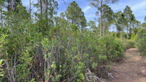
West of historic Indrio and east of Interstate 95, Lakewood Park is an enormous subdivision atop former ranchlands.
Within it, Lakewood Regional Park balances ballfields and active recreation with a buffer of natural habitats.
Explore the wooded southern portion of the park on a network of trails starting next to their popular aquatic center.
 A walk in the woods awaits
Resources





Disclosure: As authors and affiliates, we receive earnings when you buy through our links. This helps us provide public information on this website.
Overview
Location: Lakewood Park
Length: 1.4 miles
Trailhead: 27.53950, -80.41169
Address: 5990 Emerson Ave, Fort Pierce
Fees: Free; fee for pool use
Restroom: At the aquatic center
Land Manager: St. Lucie County
Phone: 772-462-1517
Open sunrise to sunset. Leashed dogs welcome. Please pick up after your pet.
Online, the county has shortened the park’s name since our visit; signage may still say “Lakewood Park Regional Park.”
Directions
From Interstate 95 exit 138 north of Fort Pierce, take Indrio Rd (SR 614) east 2 miles. Turn left on Emerson Ave (SR 607). Follow it north for 1.5 miles to Hibiscus Rd. Turn right after 0.2 mile to enter the park gates. Follow the park road straight south through the middle of the ballfields. From the circle with the giant globe sculpture, turn right and pass the aquatic center to park past it near the end of the lot.
Hike
Start along the broad graded path immediately west of the aquatic center. It’s marked by a large sign about wildlife you may see along this hike.
Passing behind the aquatic center, walk along the west side of a large man-made pond. Alligators may laze on the grassy shoreline.
 Starting point
Cross a broad pedestrian bridge and the trail swings closer to the pine flatwoods. An unmarked path takes off into the pines.
Pass it by in favor of the next trail junction, a clear Y in the graded path. Enter the pine forest and merge into a broad trail at a junction with a trail map.
 Junction of graded paths
Essentially a forest road, the pathway winds beneath the pines. Each curve hides the next turn thanks to a thicket of palm fronds filling the understory.
Sword ferns cluster in damp spots in these pine-palm flatwoods. After a sharp curve, the shoulders of the forest road widen, adding to the towering appearance of the slash pines.
 Curving forest road
A half mile into the hike, a narrow footpath forks to the left at a junction with a trail map. Follow it to burrow into the pine flatwoods.
Fronds spill into the trail corridor, a pleasant walk in the woods on a soft carpet of pine duff.
 Turn off onto this footpath
Curve past showy grassy coves dotted in delicate wildflowers against a backdrop of a thicket of gallberry.
Many pines are young with skinny trunks, likely second generation growth after timber operations long ago. Mature saw palmetto forms a wall along the footpath.
 Saw palmetto
At 0.7 miles, meet the main graded path that you’d left at the first junction, now at a point south of the pond. Turn right.
Follow the curves of this broad graded path under the shade of overhanging oaks. A swarm of marsh ferns form a green ribbon at the base of the saw palmetto.
 T with graded path
Around a curve, the habitat shifts to more palms, less pines, in these pine-palm flatwoods.
As the trail dips to its southernmost point, houses just beyond the park boundary are briefly visible.
Turn away from them into scrubby flatwoods on slightly higher, drier ground.
 Curve past opening to subdivision
After a few curves, watch for a well-defined trail corridor on the left at a mile. Turn onto this footpath, walled on both sides by the dense vegetation.
The habitat shifts to damp, as tis part of the pine forest edges a large wetland hidden in the woods.
 Narrow footpath
Bright yellow blossoms of candyroot stand out against the brown pine needles at your feet.
Cabbage palms rise above the dense thicket of gallberry and vines making up the understory. The grassy path may be a little soggy in low spots.
 Tight corridor
Rise to higher ground, with a brief glimpse of the open grounds of the park along a curve.
From a canopy of palms and skinny pines, a splash of light signals the end of the footpath at 1.2 miles.
 Shady hammock near end
Emerge onto a paved path, with the graded path you’d left meeting it at a nearby junction.
The paved path circles the north side of the park counterclockwise.
Use it if you want to add an extra half mile to your walk to stretch to 2 miles.
However, it doesn’t stay in the forest for long and mainly circles the ballfields in full sun.
 Meeting the paved path
Instead, turn left, exiting the woods. Follow the broad sidewalk paralleling the park road.
Pass the big pond, walking past the aquatic center to complete this loop after 1.4 miles.
 Sculpture in roundabout
Trail Map

Explore More!
Video
Hiking Lakewood Regional Park
Slideshow
See our photos from Lakewood Regional Park
Nearby Adventures
 Hallstrom Farmstead Encircling the historic Hallstrom House, sand pine scrub provides a unique habitat for a rare and endangered species of native mint along this 1.4 mile loop.
 Sheraton Scrub Preserve Explore an easy loop in scrubby uplands in residential Fort Pierce to search for scrub-jays from ground level and from an observation tower.
 D.J. Wilcox Preserve Discover the natural beauty of a mosaic of habitats nourished by a freshwater spring near the Indian River Lagoon at what was once the town of Indrio.
 Indrio Savannahs Preserve A haven for wildlife dependent on fresh water savannas scarcely a mile west of the Indian River Lagoon, Indrio Savannahs illustrates a success story in habitat restoration.

- Michael Crotty Bicentennial Park - November 3, 2026
- A.J. Henry Park - November 1, 2026
- Okeeheelee Nature Center Trails - October 22, 2026