
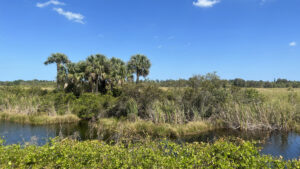
A 550 acre preserve, Savannas Recreation Area encompasses the northern extent of the freshwater savannas stretching from Fort Pierce to Jensen Beach.
Most of this preserve is a massive marsh. Within a slender strip of pine flatwoods and scrub, this county park contains a campground, picnic area and launch.
 The freshwater savannas
Visitors can rent a canoe or kayak at the Trading Post, a restored turn-of-the-last-century home serving as a part office.
Or bring a bike or plan to hike two distinctly different paths within the high ground of this preserve.
 Launch between the Trading Post and the campground
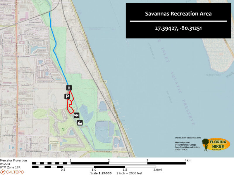
From the campground, a mile loop incorporates a levee along the marsh and a spur to an observation tower with a birds-eye view of the savannas.
At the north end of the unpaved park road, a sidewalk parallels a canal, with views of the vast marsh along a 2.8-mile round trip.
 The sidewalk offers excellent birding and wildlife watching
Resources





Disclosure: As authors and affiliates, we receive earnings when you buy through our links. This helps us provide public information on this website.
Overview
Location: Fort Pierce
Length: 3.4 miles
Trailhead: 27.39526, -80.31238
Address: 1400 E Midway Rd, Fort Pierce
Fees: Free
Restroom: At the Trading Post
Land manager: St. Lucie County
Phone: 772-464-7855
Open sunrise to sunset. Leashed dogs welcome. Call to reserve a campsite. Both trails are sun-drenched; use sun protection.
Use caution along the trails and while paddling as alligators are present. Do not approach them.
Directions
From Interstate 95, take exit 126. Follow Midway Rd east 5.3 miles to US 1. Continue another 1.4 miles to a turnoff on the left into the park, immediately past a junction with Weatherbee Rd. Follow the park road past three turnoffs on the right. The first leads to the Trading Post, the next two, into the campground. Pass a pedestrian bridge and the dog park. Park on the left along a grassy strip north of the dog park.
Hike
Start with the easier and longer of the two trips by walking north along the park road for 0.2 miles to where it ends at a small unpaved circle.
Slip between the stanchions to begin the North Trail. Laid atop a berm within the marsh, the sidewalk parallels a stand of pines and oaks.
 Start of the North Trail
The trees end, and the path curves along a boundary canal edging the west side of the savannas. A housing development sits to the west.
At 0.4 miles, the path turns away from it. A long bridge with alligator warning signs arcs through an open water pond amid a marshy cove.
 Marsh bridge
Continue through a curve, passing a bench in the sun. Behind it is an expanse of very shallow marsh.
The trail straightens out, the canal beside it looking more like a natural waterway. Spoil piles on its east side support stands of cabbage palms and line slash pines.
 Tree-lined waterway
Cross a bridge allowing water to flow beneath the levee. A straightaway leads into a short stretch where tall Australian pines provide dappled shade.
At 1.1 miles, cross the next bridge. A dense willow marsh expands to the west. Beyond it, low marsh adjoins both sides of the path.
 Shady spot
Seasonally, the tall forms of marsh mallow riffle in a salty breeze off the nearby Indian River Lagoon.
At 1.4 miles, the path ends at another set of stanchions. A railroad trestle peeks above the vegetation beyond, where the high-speed Brightline zooms past frequently.
 Trail’s end
Since Indian Hills Recreation Area is on the opposite side of that trestle, perhaps the county will connect the parks in the future.
Doing so would enable a realignment of the East Coast Greenway off of roads and past the campground, useful for long distance cyclists.
 Marsh at the north end of the trail
Turn around and retrace the route, using the different angle of light and shadow to watch for alligators sunning, the splashes in the canal for otters swimming.
Exit the sidewalk onto the park road at 2.6 miles, walking another 0.3 miles to the bridge leading to the Campground Loop.
 Follow the road to the pedestrian bridge
Cross the bridge and turn right. Cross the second bridge within view and turn right. Depending on water levels, the grass may be damp.
Circle the south end of the marsh and reach a T junction. To the right, the footpath extends 0.2 miles to a bridge into the campground. Turn left instead.
 South end of marsh
Join the path above the marshy swale. It becomes a narrow two-track between cabbage palms and climbs onto a levee.
Enjoy views from gaps in the vegetation. To the west, bay trees and marsh ferns edge a deepening marshy pond dotted with water lilies.
 Marshy pond
Eastward, cattails part to reveal a ditch dotted with large water lilies. The expanse of the savannas lies beyond.
When a breeze blows west from the Atlantic, it’s always cool, the open water of the savannas acting like a swamp cooler.
 Marshes to the east
Views to an ever-deepening marsh open up between the oaks and pines adding shade. A bed of pine duff makes for more pleasant footing.
At the north end of the central marsh, 0.3 miles into the Campground Loop, a palm-lined spur trail leads further north to the observation tower.
 Spur trail to the tower
It’s atop one flight of stairs, enough to offer a panorama southward across the marshes and canal.
Return south along the spur trail. Bear right at the junction to walk the west side of the loop around the central marsh.
 View south across the preserve
A series of signs within an oak hammock deliniate the locations of the primitive group campsites. The path is indistinct once more; stay west of the marshy grassland.
Paralleling the canal along the park road, reach the pedestrian bridge. Cross it and return a tenth of a mile north to the parking area, completing a 3.4 mile hike.
 Walk back up the road past the dog park
Trail Map
Explore More!
Video
Hiking Savannas Recreation Area
Slideshow
See our photos from Savannas Recreation Area
Nearby Adventures
 Ancient Oaks Preserve On an easy mile loop amid the grandeur of an ancient hydric hammock, savor shade, shape, and form in a hidden wild space in the St. Lucie River floodplain in Fort Pierce.
 Sweetwater Hammock Preserve Marvel at the botanical beauty of a mature live oak hammock on this short nature trail loop to a bluff along the North Fork of the St. Lucie River.
 Savannas Preserve State Park At Savannas Preserve State Park, a grand expanse of wet prairies and pine flatwoods extends across two counties to the west of the Indian River Lagoon.
 Walton Scrub Preserve Explore the high ground between the bluffs above the Indian River Lagoon and the basin marshes of Savannas Preserve State Park atop the Atlantic Coastal Ridge.

- Hal Scott Red Trail - November 13, 2026
- Baseline Trails - November 7, 2026
- Hal Scott Yellow Trail - November 3, 2026