
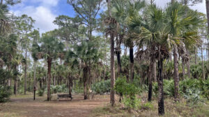
In a relatively small corner of vast recreation-focused Okeeheelee Park, an array of natural habitats remain behind the Okeeheelee Nature Center
Paved trails loop through them to points of interest like the deer enclosure and a wetlands pond. Colorful interpretive signs identify plants along the route.
 On the Pine Trail
These accessible paths connect with a broader network of footpaths through pine flatwoods, skirting natural ponds and marshes.
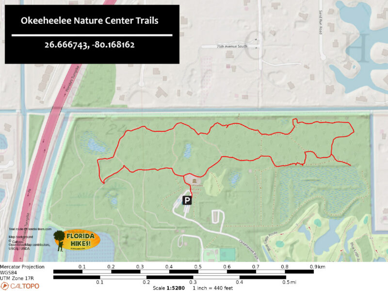
Pick up a trail map to make use of the signage at trail junctions to follow the 1.7 mile outer loop described below.
 Trail junctions are largely signposted
Resources



Disclosure: As authors and affiliates, we receive earnings when you buy through our links. This helps us provide public information on this website.
Overview
Location: Greenacres
Length: 1.7 miles
Trailhead: 26.66674, -80.16816
Address: 7715 Forest Hill Blvd, West Palm Beach
Fees: Free
Restroom: At the trailhead
Land Manager: Palm Beach County
Phone: 561-252-1714
Trails open sunrise to sunset. Nature center open 1-4:30 Wed-Fri, 10-4:30 Sat. Restroom access limited to 9-4:30 Tue-Sat.
No pets or bicycles. No smoking.
Directions
From Interstate 95 exit 66 in West Palm Beach, follow Forest Hill Blvd west for 5.9 miles. Turn right at the second entrance into the park at the traffic light across from Okeeheelee Park South. Follow the outer park road, Eshelman Trail, for 1.2 miles to the road to the nature center. Continue 0.4 miles to the end of that road to the parking area in front of the center.
Hike
Follow the sidewalk around the nature center past the restrooms. Past the first turnoff on the left, start a counter-clockwise walk on the Cypress Trail.
Continue around the back of the building past a bird feeding station. Beyond the Nature Center Trails sign, the sidewalk becomes a paved path.
A low fence divides the Cypress Trail from an open green space. Pass the East Wetland Trail sign. Its route across the open area is not clearly defined.
 Start of the Cypress Trail
Curve into a mesic flatwoods with South Florida slash pines as the high canopy and cabbage palms and oaks below. Interpretive signs identify trees and plants.
At 0.2 miles, leave the pavement to start the West Burn Trail. This well-worn path passes a screened outdoor classroom.
 Curving into mesic flatwoods
At a junction with a sign planted in a bed of sword ferns, continue straight ahead to join the East Burn Trail.
The path is walled in by saw palmetto and young oaks. Pass a chained vehicle gate.
 Start of the East Burn Trail
A low bluff soon provides places to step out and look across a basin marsh thick in its shallows with periphyton, the primary biomass of the Everglades.
Wading birds like great egrets and tri-color herons stalk its edges.
 Large basin marsh
Follow the East Burn Trail around a curve where an arrow points left. Lined by tall skinny pines and cabbage palms, its broad corridor meets a junction at a bench.
Turn right to start the Cabbage Palm Trail, an immersive walk in pine-palm flatwoods on a soft carpet of pine duff. Shoelace fern drapes from lichen-covered palm trunks.
 Trail junction at bench
Meeting a junction with the Marsh Trail at a curve, bear right. The pathway tunnels under younger oaks to reach a bird blind on the marsh at a half mile.
Returning to the Cabbage Palm Trail, bear right. The pine-palm flatwoods are dense with columns of cabbage palms on the approach to the next bench.
 View from the bird blind
Approaching the north boundary of the park, homes are visible through a screen of trees. Curve west through the flatwoods, meeting a junction under the pines.
Take the right side to curve around North Pond, where hog plum thrives and pond apples frame a view of the small wetland.
 North Pond
At the junction just past it, join the upper portion of the East Burn Trail. Soon after, a broadening of the path occurs at its junction with the upper West Burn Trail.
Veer right, continuing west. The flatwoods are more lush in this corner of the preserve.
 Along the West Burn Trail
At a mile, a clearing with a cable gate to the right reveals the levee separating the park from surrounding neighborhoods.
Within a tenth of a mile, the footpath ends at the Cypress Trail. Turn right onto the paved path.
 Cypress Trail junction
Along it, plant identification markers add points of interest on the stroll through the flatwoods. At a junction of paved paths, continue straight ahead.
Begin the Pine Trail. Pass a tall pine with a deep catface groove in its trunk from a century or more ago when it was tapped for turpentine.
 Catfaced pine
Curve past a bench through the stand of pines to a detailed interpretive station explaining the pine flatwoods ecosystem.
At the next junction, the Pine Trail turns left. Continue straight ahead, but not before a stop at West Pond. A bank of benches overlooks it.
 West Pond
The hum of distant traffic increases on the walk around the pond, loudest at the overlook bluff at 1.4 miles.
This high point provides a nice perspective for birding. Florida’s Turnpike is right beyond the trees.
 West Pond from overlook
The paved circuit continues away from the bluff as the Wildlfe Trail, leading to an overlook above a large deer enclosure.
While we as hikers think of white-tailed deer as commonplace residents of the preserves we hike, for city residents visiting this park, seeing deer here is a treat.
 Deer enclosure blind
Curving past the enclosure, follow along a wooden fence under a portion of the flatwoods busy with bracken fern.
Rejoin the Pine Trail by bearing right at the junction with it. Slash pines tower overhead on this last stretch towards the nature center.
 Among the ferns
The forest’s thick understory makes it a haven for native wildlife, as an interpretive sign points out.
Where the Cypress Trail merges in from the left, continue straight ahead to reach the nature center. Turn right to exit to the parking area, completing this 1.7 mile hike.
 Returning to the nature center
Trail Map
Explore More!
Video
Hiking at Okeeheelee Nature Center
Slideshow
See our photos from Okeeheelee Nature Center
Nearby Adventures
 Winding Waters Natural Area Miles of marked trails wind through restored wetlands and pine forests teeming with birds on a large parcel of land saved from development after years of agricultural use.
 Apoxee Wilderness Trail In the wet prairies and tropical hammocks of Apoxee Wilderness, an urban wilderness area, tackle a 4.7-mile day hike through the southernmost part of Grassy Waters Preserve.
 Pine Jog Wetlands Hammock Trail An outdoor classroom for schoolchildren, Pine Jog Environmental Center is also open to the public to explore the deeply forested 135-acre urban property on an array of short nature trails.
 John Prince Park Custard Apple Trail Winding through a tropical hammock and along open marshes, the interpretive Custard Apple Trail provides a taste of the wilderness that once covered Lake Worth.

- Michael Crotty Bicentennial Park - November 3, 2026
- A.J. Henry Park - November 1, 2026
- Okeeheelee Nature Center Trails - October 22, 2026